Winter Weather Likely Midweek
A rapid warm-up is expected on Monday, but the warm temperatures won't last long as winter weather makes its way into Green Country to close out the week.Monday, January 31st 2022, 7:51 am
TULSA, Oklahoma -
A rapid warm-up is expected on Monday, but the warm temperatures won't last long as winter weather makes its way into Green Country to close out the week.
News On 6 Meteorologist Alan Crone has the latest update in his daily weather blog.
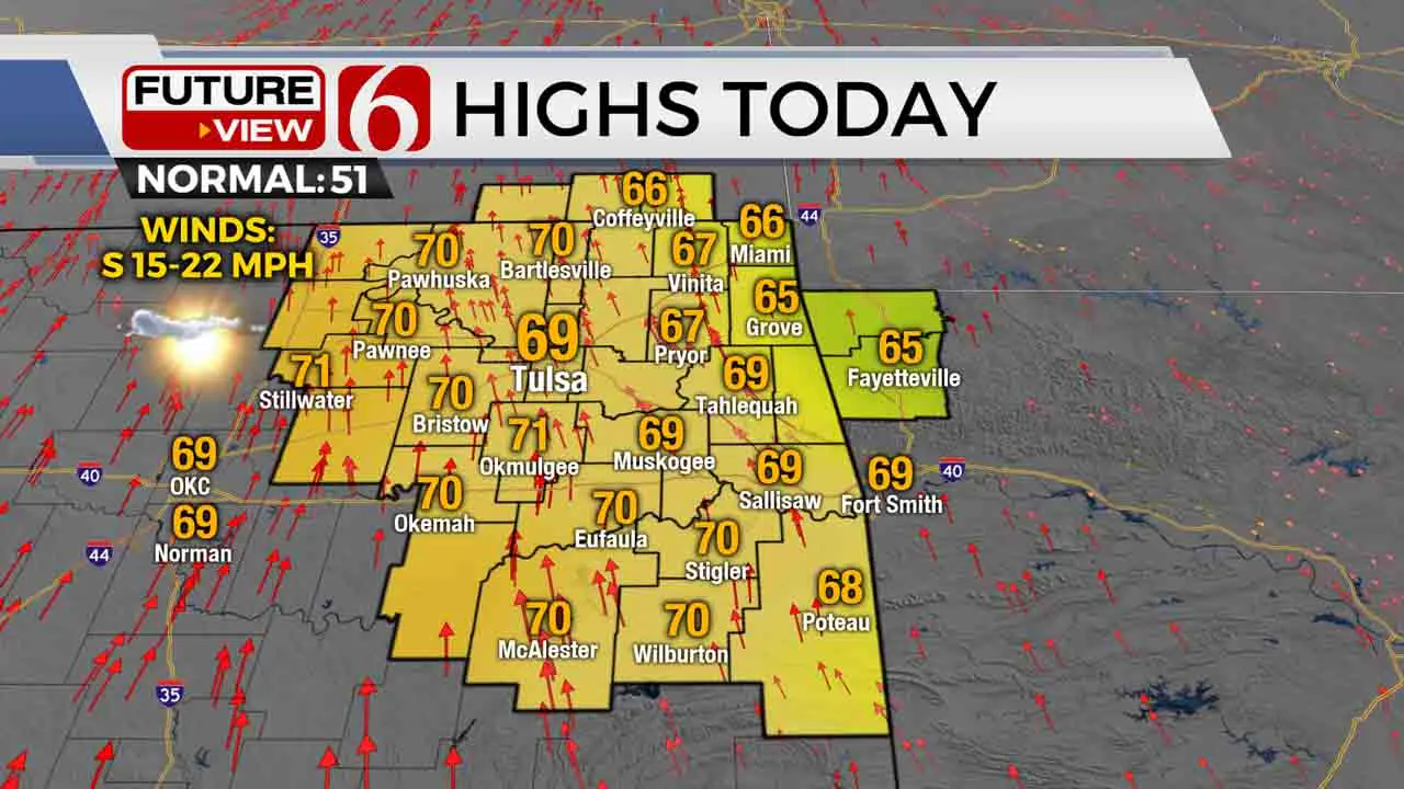
Sunshine and highs in the upper 60s and lower 70s will be likely Monday before the arrival of a significant winter system that will impact the state for the midweek period. Gusty south winds will slowly increase later in the day and night before the leading edge of colder air arrives late Tuesday afternoon and evening.

A stout arctic front enters northern OK Tuesday afternoon and quickly moves southeast by the evening. Temps will drop from the upper 50s Tuesday afternoon to near freezing by early Wednesday morning across the northern third of the area before finally bringing freezing temps to southeastern OK late Wednesday evening. Rain will begin late Tuesday afternoon in southern Kansas and eventually transition to wintry weather Wednesday and Thursday as it continues to impact part of Oklahoma.
This precipitation with this system will come in several different waves, intensities, and precipitation types.

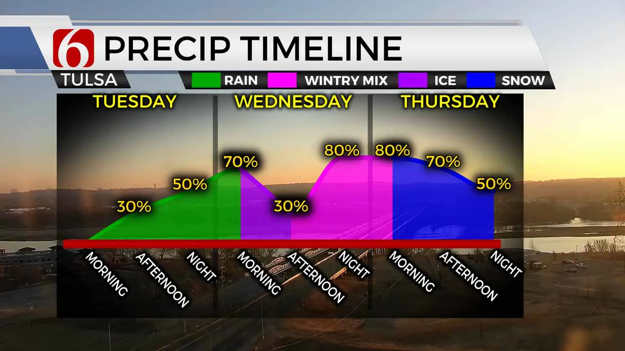
The first wave passes north of the state Tuesday but brings some rain into the northern OK region Tuesday evening into pre-dawn Wednesday. The colder and deeper air across southern Kansas will support mostly snow during this period. Locations near the Tulsa metro will see light rain or drizzle transitioning to a period of light freezing rain. We may also see a minor break in precipitation by Wednesday midday before the main upper-level system nears from the southwest Wednesday evening. As the main upper-level system nears the state, precipitation will develop across the Red River and expand northeast. Wednesday midday to afternoon the freezing rain zone moves into southeastern OK, while some precip may change to sleet by the afternoon across the I-44 corridor. Locations near I-40 northward to I-44 will see a sleet-snow mix initially before becoming all snow by late Wednesday evening. Southeastern OK may continue to see mostly freezing rain until colder air arrives changing precip to some sleet by Wednesday night. The main upper-level impulse will travel east of the state pre-dawn Thursday, but another weaker upper-level feature will bring another round of light snow across most of the area Thursday afternoon before exiting by the evening hours.
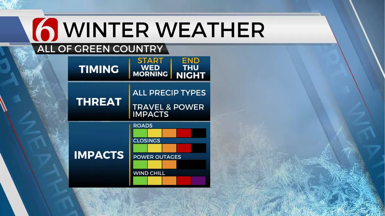
Impactful amounts of freezing rain, sleet and snow will be possible with this system. Higher snow totals seem likely along and northwest of the I-44 corridor into southern Kansas. The area between I-40 and I-44 may be impacted by sleet before changing to snow. Locations across southeastern OK could have significant ice issues, resulting from .25 to near .50 inches of ice. The potential for a significant ice event across southeastern OK is increasing.

Temps will be frigid for the next five to seven days once the front moves across the state. After Monday's highs in the upper 60s and lower 70s, Tuesday begins the transition day from the 50s into the colder air. The Tulsa metro will stay below freezing from Wednesday morning through most of the weekend. Bitterly cold air is likely Thursday through Saturday. Wind chill values are supportive of subzero to -12 values during the morning hours.
Thanks for reading the Monday morning weather discussion and blog.
Have a super great day!
Alan Crone
KOTV
More Like This
January 31st, 2022
June 21st, 2023
June 19th, 2023
June 13th, 2023
Top Headlines
December 12th, 2024
December 12th, 2024
December 12th, 2024


