

Tracking Above Normal Temperatures
A warm and muggy Wednesday is ahead after a round of overnight storms swept across parts of the state.Wednesday, May 11th 2022, 6:29 am
TULSA, Oklahoma -
A warm and muggy Wednesday is ahead after a round of overnight storms swept across parts of the state.
Here are the details from News On 6 Meteorologist Alan Crone:

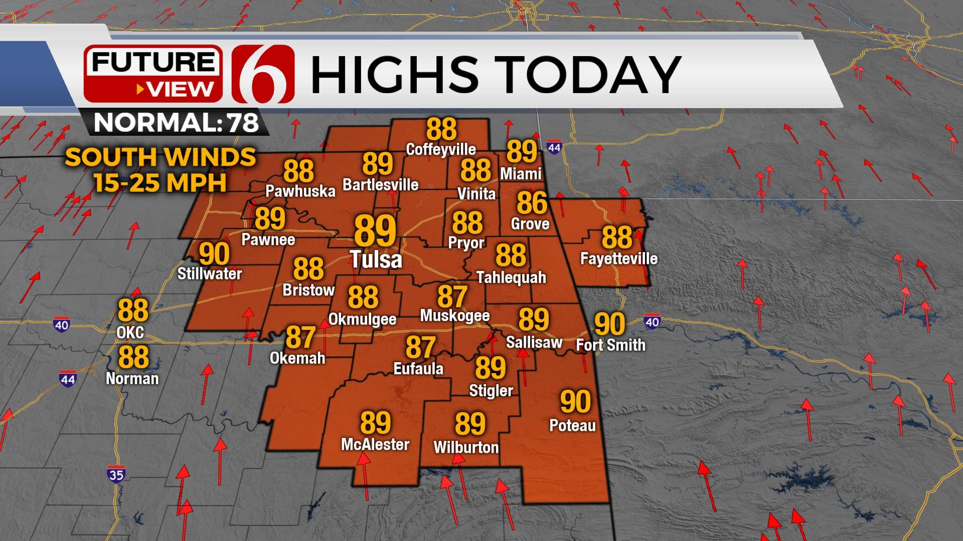
Tuesday night’s storms across western OK deposited a weak convectively induced area of vorticity (MCV) that will float northeast into our area later Wednesday. This feature may be able to spark off a few showers or storms but the presence of the mid-level ridge of high pressure should still be strong enough to prohibit most of this from occurring. Otherwise, we’re looking at more summerlike weather today and tomorrow with afternoon highs in the upper 80s and lower 90s. South winds will also remain at 15 to 25 mph with mostly to partly cloudy sky. Slightly drier air should sneak into the area this afternoon with the result being slightly lower afternoon humidity. The pattern should change some this weekend allowing storm chances and a weak front entering the area bringing some minor relief from the early summerlike heat and humidity.

Thursday night into Friday a powerful upper-level low will eject from the four corners region into the northern high plains where severe weather threats will occur. At the base of this trough, a disturbance will produce a few storms Thursday night across south-central Kansas. The upper air flow will be transiting to the northwest into early Friday. Some of these storms will have the chance to move southeast along the flow into northeastern OK early Friday morning. By Friday afternoon and evening, additional storms are likely to develop across central Kansas and a few of these could migrate southeast into our area, including the mention for a few strong and severe storms. The data remain highly inconsistent with this scenario, but the pattern will be favorable for this chance.

We have increased the probabilities Friday evening into early Saturday morning due to this possibility. A weak front will also slide southward, entering the area early this weekend and may bring north winds Saturday afternoon and early Sunday but with no appreciable cooler weather. More warm and windy weather will remain at least for the early part of next week.
Thanks for reading the Wednesday morning weather discussion and blog.
Have a super great day!
Alan Crone
KOTV
If you’re into podcasts, check out my daily weather update. Search for NewsOn6 and ‘Weather Out The Door’ on most podcast providers, including Spotify, Stitcher and Tune-In, or Click Here to listen on Apple Podcasts.

Get The Daily Update!
Be among the first to get breaking news, weather, and general news updates from News on 6 delivered right to your inbox!
More Like This
May 11th, 2022

June 21st, 2023

June 19th, 2023

June 13th, 2023
Top Headlines

December 11th, 2024

December 11th, 2024
December 11th, 2024

December 11th, 2024