Gusty Winds, High Fire Danger
A sunny and breezy day is ahead, but shower chances could soon return for the weekend.Thursday, October 13th 2022, 7:32 am
A sunny and breezy day is ahead, but shower chances could soon return for the weekend.
Here are the details from News On 6 Meteorologist Alan Crone:
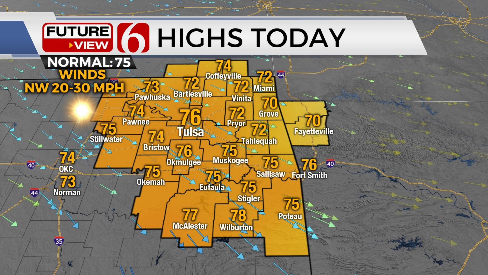
TULSA, Okla. - Sunshine and gusty northwest winds at 20 to 30 mph will allow for high fire danger issues on Thursday. Temperatures will be seasonal with lows in the 40s and 50s Thursday morning followed by afternoon highs in the lower to mid-70s.

A secondary surge of dry air moved into the area overnight setting the stage for increasing fire danger threats this afternoon. Clear sky and gusty northwest winds from 20 to 30 mph combined with drying vegetation and low humidity create a rapid fire spread on Thursday. Red flag warnings will be underway for most of the area this afternoon and early evening. A number of counties are included in official burn bands. A surface ridge of high-pressure settles across the area later this evening before exiting Eastern Oklahoma Friday morning. As this feature migrates through the area, winds return from the south to southwest Friday with daytime highs reaching the lower or mid-80s. Fire spread will remain a concern Friday. Our next cold front will approach the area Saturday afternoon bringing a chance for a few storms, including at least a slight chance for strong to severe storms for part of the region.

The upper airflow is characterized by a deep trough over Hudson Bay across the Great Lakes Region. A cut off low is positioned across the Baja into the southwestern US in the southern Stream. The upper airflow is predominantly from the northwest across the central and southern plains Thursday, Friday, and part of the weekend. A surface boundary enters northern Oklahoma Saturday mid-day while slowly advancing across the southern sections of the state by evening. Scattered showers and storms will be a possibility. Some ensemble data suggest increasing convective and potential energy during this period, combined with some increasing shear that could produce a few strong to severe storms. As the boundary sinks southward, thunderstorm activity will be more focused across southeastern Oklahoma and the North Texas region. This should be the case for most of Sunday, but a few showers or storms may persist slightly northward, especially Sunday morning.

Temperatures Saturday are expected to climb into the mid-80s before dropping Sunday into the lower 70s with north winds. A reinforcing shot of colder weather rolls across the Midwest early next week, with some cooler air arriving from the Missouri Valley into Eastern Oklahoma Tuesday. This should bring below seasonal average temperature early next week, some of the coolest of the early fall season. Tuesday and Wednesday morning, valley and sheltered locations may experience morning lows in the upper 30s with some frost possible. This cooler weather will be temporary as a return to near and normal temperatures will be expected by the end of next week.

Thanks for reading the Thursday morning weather discussion and blog.
Have a super great day!
Alan Crone
KOTV

Get The Daily Update!
Be among the first to get breaking news, weather, and general news updates from News on 6 delivered right to your inbox!
More Like This
October 13th, 2022

June 21st, 2023

June 19th, 2023

June 13th, 2023
Top Headlines

April 24th, 2024

April 24th, 2024
April 24th, 2024