Severe Thunderstorm Threats Return
The chance for severe weather returns on Friday. News On 6 Meteorologist Alan Crone has the latest in his daily weather blog.Friday, November 4th 2022, 5:49 am
If you’re into podcasts or in a rush, check out my daily weather update. Search for NewsOn6 and ‘Weather Out The Door’ on most podcast providers, including Spotify, Stitcher and Tune-In, or Click Here to listen on Apple Podcasts.
The chance for severe weather returns on Friday.
Here are the details from News On 6 Meteorologist Alan Crone:

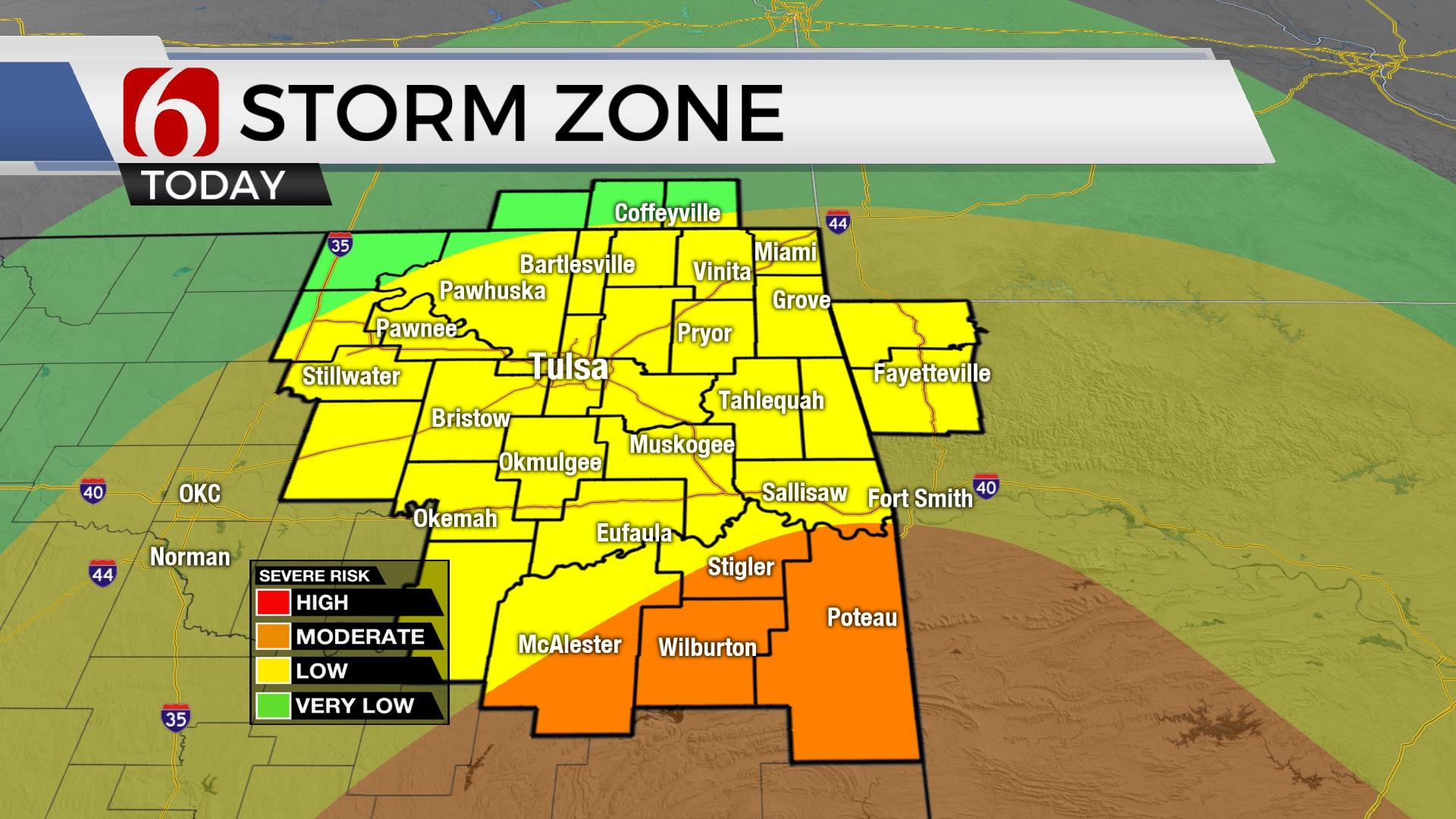
TULSA, Okla. - Strong south winds from 20 to 35 mph remain through the day with highs in the lower to mid-70s. Strong to severe storms will develop on Friday morning to our west. A few scattered storms will be possible Friday morning across eastern Oklahoma, but severe threats will be limited, yet not impossible. By late morning and early afternoon additional storms will develop, including threats for severe storms. All modes of severe weather will be possible. Higher instabilities are expected east of highway 69 and south of I-40, across southeastern Oklahoma into a large area of northeast and north central Texas. This is the area of higher tornado threats Friday afternoon and early evening. Severe threats will extend northward to the Tulsa metro, but higher chances for severe weather will remain east and south.

As we're posting early Friday morning, the strong upper-level trough is northwest of the state with powerful upper-level winds at 90 to 100 knots rounding the base of the trough. Wind speeds are increasing from lower levels to the mid-levels from the southwest. About five thousand feet above ground level, south to southeast winds are blowing from speeds of 30 to near 50 knots. Low level moisture in the form of dew points in the 60s are now in place across our immediate area with lower 70s, tropical-like moisture across part of east Texas into the Golden Triangle region. Storms developed overnight across northwestern Oklahoma and southwestern Kansas and are now approaching central Kansas and a few spots west of I-35 in Oklahoma. Scattered showers will attempt to form Friday morning across Eastern Oklahoma, but the severe threats should remain initially low. By midday, nearing the noon to 1 p.m. hour, additional scattered storms are likely to develop in the vicinity of a westward moving frontal boundary near I-35. These storms will be in a better time-space parameter for severe characteristics and will grow in severity and frequency of storms from 2 p.m. to 7 p.m. around the metro and highway 75 corridor. Locations eastward may continue to see strong to severe storms from early afternoon until 8 p.m. to 11 p.m. The faster progression of the system should exit severe weather threats before midnight across far eastern Ok and western Arkansas. A few wrap around showers are possible due to the upper level trough overnight into pre-dawn Saturday, but these will be located to our north, across southeastern Kansas. The air mass behind this departing system is a blend of Canadian and Pacific air. As the front passes your area this evening, temps will drop into the 50s. This airmass will result in a minor cool-down for Saturday afternoon with highs in the mid-60s. A chilly start will be likely, however, with Saturday morning lows in the 30s and 40s. Gusty southwest to west winds are likely Saturday from 15 to 25 mph. Warmer weather returns Sunday with highs in the lower to mid-70s.

By the middle of next week, the battle between cold and warm intensifies as a series of strong upper-level troughs will move across the flow. Colder air continues to grow across Canada and will begin migrating southward with each passing trough. Initially, our pattern will support above normal temperatures early next week along with gusty south winds from 15 to 30 mph. A return of deeper moisture moving from the southeast to northeast Monday into Tuesday supports a mention for a few scattered showers and storms, including Election Day morning. As the next strong upper-level trough moves across the intermountain region with snow next week, a surface low pressure area will eject into the central and northern plains Thursday and Friday. This will bring a stronger cold front into the state with a notable cool-down with much colder weather across the northern third of the nation. The following week, additional waves will help to dislodge some of this colder air and eventually it will flow southward, nearing the state by the third week in November.

Thanks for reading the Friday morning weather discussion and blog.
Have a super great day!
Alan Crone
KOTV

Get The Daily Update!
Be among the first to get breaking news, weather, and general news updates from News on 6 delivered right to your inbox!
More Like This
November 4th, 2022

June 21st, 2023

June 19th, 2023

June 13th, 2023
Top Headlines

April 24th, 2024

April 24th, 2024

April 24th, 2024