Blustery Friday Before Improving Weather Arrives
Parts of the state could see some spotty flurries on Friday as the cold weather sticks around.Friday, November 18th 2022, 6:30 am
TULSA, Okla. -
If you’re into podcasts or in a rush, check out my daily weather update. Search for NewsOn6 and ‘Weather Out The Door’ on most podcast providers, including Spotify, Stitcher and Tune-In, or Click Here to listen on Apple Podcasts.
Parts of the state could see some spotty flurries on Friday as the cold weather sticks around.
Here are the details from News On 6 Meteorologist Alan Crone:

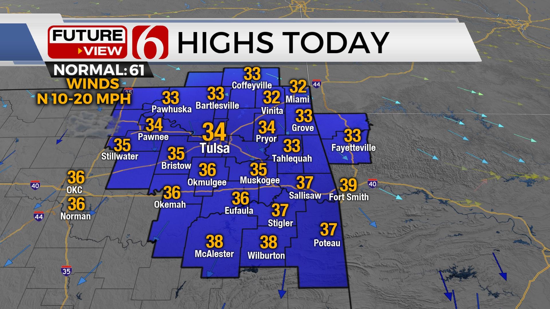
Blustery weather is underway with cloudy, breezy, and cold weather. A few snow showers remain early Friday morning before transitioning to spotty flurries through the day. Highs on Friday will remain near or slightly above freezing near the metro with some minor variations from the north to south across the region. Clouds will gradually clear from the north to south overnight allowing bitterly cold Saturday morning temps. Some locations will start in the teens across far northeastern while southeastern OK remains in the mid-20s on Friday morning. Saturday afternoon highs are expected in the lower 40s north and upper 40s south with mostly sunny conditions. Bedlam in Norman supports game time temps in the 30s with mostly light wind and no precipitation.

The front continues progressing southward with gusty north winds from 10 to 20 mph across most of northeastern Oklahoma. These winds will create wind chills from the teens to mid-20s Friday morning into midday. Wind speeds will decrease on Friday afternoon and evening.

A mid-level front is producing some scattered snow showers across part of the area early Friday morning resulting in a minor dusting. Additional measurable snow will occur across Northwest Arkansas where travel advisories remain until 9 a.m. Please use caution driving on Friday morning. Some roadways remain wet with temperatures near freezing. Most of the snow bands will quickly end, but interment flurries will be possible Friday afternoon and possibly Friday night.

Later on Friday evening, another mid-level disturbance dives across the western Oklahoma region and may squeeze out some additional snow showers or flurries across the southern sections with no impacts. The Tulsa metro may see some flurries, but the probability remains low. The cold weather sticks around Friday, but will slowly modify this weekend with highs Saturday in the 40s and Sunday reaching the lower 50s and upper 50s early next week. The pattern will bring another system near the state around Thanksgiving but there continue discrepancies regarding the overall impact. I'll refrain from too many scenarios for now, but just post the potential for a few showers remaining Wednesday night into Thursday morning. Thermal profiles do not support any wintry weather impacts currently. Below normal temps in the 50s are likely for afternoon highs.
Thanks for reading the Friday morning weather discussion and blog.
Have a super great day!
Alan Crone
KOTV

Get The Daily Update!
Be among the first to get breaking news, weather, and general news updates from News on 6 delivered right to your inbox!
More Like This
November 18th, 2022

June 21st, 2023

June 19th, 2023

June 13th, 2023
Top Headlines

April 22nd, 2024

April 22nd, 2024

April 22nd, 2024