

Storms Move Away From Green Country
Showers and storms hang around on Tuesday morning.Tuesday, December 13th 2022, 11:56 am
If you’re into podcasts or in a rush, check out my daily weather update. Search for NewsOn6 and ‘Weather Out The Door’ on most podcast providers, including Spotify, Stitcher and Tune-In, or Click Here to listen on Apple Podcasts.
TULSA, Okla. - Showers and storms hang around on Tuesday morning.
Here are the details from News On 6 Meteorologist Alan Crone:

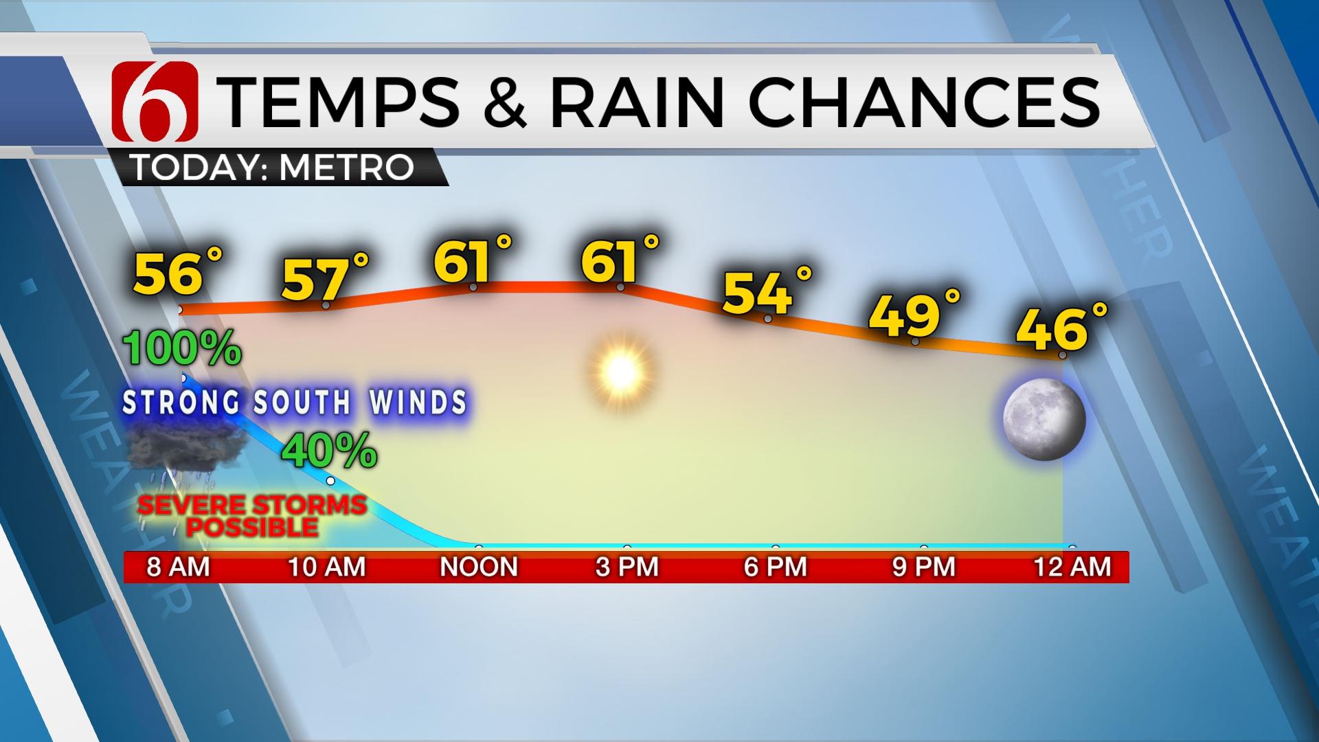
Storms are likely on Tuesday morning ending by midday. Some storms may be strong to severe before exiting eastern Oklahoma early Tuesday afternoon. Remain aware of your weather conditions and be prepared to act if warnings are issued for your area.

A powerful upper-level system is driving the weather on Tuesday with strong to severe thunderstorm chances for the next few hours. The wind shear values are very favorable for severe weather, but the surface instability is expected to remain meager for most of the area. As the pacific front quickly advances east on Tuesday morning, a line of thunderstorms will form and move east. The primary threat from these storms will be damaging winds and some hail, mostly along and south of I-40. But a small threat will remain for the areas near the metro due to strong wind fields aloft. There will be parameters supporting quasi-linear type tornadoes along the line. These are circulations that quickly form along the leading edge of squall line type features. These parameters may be slightly higher as the line encounters locations along and south of I-40 this morning along the Red River Valley. The front should clear the state around noon with severe weather threats ending for Oklahoma but continuing for locations east and southeast of the state.

Temps on Tuesday afternoon will reach the upper 50s to some lower 60s before falling into the 40s by late afternoon and evening. Strong southwest winds this morning will back from the west and northwest tonight while remaining gusty. As the front moves east, clouds should clear with some sunshine returning this afternoon from the west to east. Wednesday morning lows start in the upper 20s and lower 30s with afternoon highs in the upper 40s north to lower 50s south. A second surge of colder air arrives Thursday morning as a surface ridge builds into the region bringing lows in the 20s and 30s and highs in the lower 40s. Our next system will be near the state early next week with even colder air, arctic air arriving. This should keep us in the deep freeze through at least Christmas and possibly through the end of the month.

Remain aware of your weather surroundings on Tuesday morning. Be prepared to take precautions if warnings are issued for your area.
Thanks for reading the Tuesday morning weather discussion and blog.
Alan Crone
KOTV

Get The Daily Update!
Be among the first to get breaking news, weather, and general news updates from News on 6 delivered right to your inbox!
More Like This
December 13th, 2022

July 3rd, 2023

June 8th, 2023
June 6th, 2023
Top Headlines

December 13th, 2024

December 13th, 2024

December 13th, 2024

December 13th, 2024