Another Blustery Day Underway
The cold and windy weather hangs around into the weekend.Friday, December 16th 2022, 7:09 am
If you’re into podcasts or in a rush, check out my daily weather update. Search for NewsOn6 and ‘Weather Out The Door’ on most podcast providers, including Spotify, Stitcher and Tune-In, or Click Here to listen on Apple Podcasts.
TULSA, Okla. - The cold and windy weather hangs around into the weekend.
Here are the details from News On 6 Meteorologist Alan Crone:
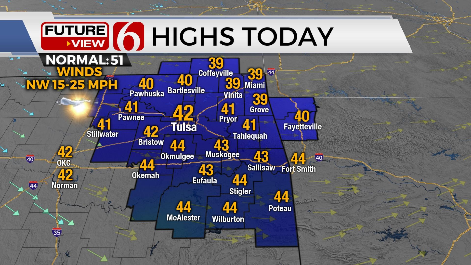
The coldest weather of the week arrives on Friday with morning lows in the 20s and afternoon highs in the upper 30 and lower 40s. Breezy northwest winds from 15 to 25 mph create wind chills in the upper teens this morning and lower 30s by afternoon.

A weak wave traversing the panhandle will produce some midlevel clouds this morning before moving southward by midday. A few flurries may squeeze out of the cloud deck but seem unlikely to survive to the surface due to the lack of low-level moisture.

Saturday afternoon highs stay in the mid-40s with Sunday reaching the upper 40s and lower 50s before a fast-moving system brings a few showers nearby late Sunday evening into early Monday morning. There remains a possibility of a rain-to-wintry mix as the system quickly exits the area early Monday. Cold to chilly weather remains early next week before a significant surge of arctic air arrives with bitterly cold weather that will last into the Christmas Holiday weekend.

The first issue remains the Sunday evening and Monday morning system. An upper-level wave near the Baja will move east into the state Sunday evening and exit early Monday morning. As the wave approaches, south winds return Sunday as low-level moisture attempts to move northward by early Monday. Most data support temps in the mid to upper 30s early Monday morning with afternoon highs reaching the lower 40s. As colder air aloft passes over the area, a very small window may exist early Monday across far northern OK and southern Kansas northward for some light wintry mix. Current data would keep higher chances more northward into part of southeastern to central Kansas.
As the surface low moves east Monday afternoon, north winds return with temps dropping into the 20s late Monday late into early Tuesday morning. Precipitation will be east of the state before the colder air arrives early Tuesday with an initial surge of cold air. Tuesday afternoon highs will stay in the mid-30s. Wednesday appears to be a transition day before the main surge of arctic air blows into the area either late Wednesday night or early Thursday morning. As this occurs, strong northwest winds arrive from 20 to 40 mph with plummeting temps.

The colder, arctic air is likely to impact the region lingering into the Christmas Holiday weekend. You’ll see and hear a lot about this colder weather over the next few days. Keep in mind, additional changes are possible, even likely before we get into early next week.
Thanks for reading the Friday morning weather discussion and blog.
Have a super great day!
Alan Crone
KOTV

Get The Daily Update!
Be among the first to get breaking news, weather, and general news updates from News on 6 delivered right to your inbox!
More Like This
December 16th, 2022

June 21st, 2023

June 19th, 2023

June 13th, 2023
Top Headlines

April 24th, 2024

April 24th, 2024


April 24th, 2024
