

Winter Storm Warnings, Advisories Underway
Winter weather returns to Green Country on Tuesday.Tuesday, January 24th 2023, 7:36 am
TULSA, Okla. -
If you’re into podcasts or in a rush, check out my daily weather update. Search for NewsOn6 and ‘Weather Out The Door’ on most podcast providers, including Spotify, Stitcher and Tune-In, or Click Here to listen on Apple Podcasts.
TULSA, Okla. - Winter weather returns to Green Country on Tuesday.
Here are the details from News On 6 Meteorologist Alan Crone:

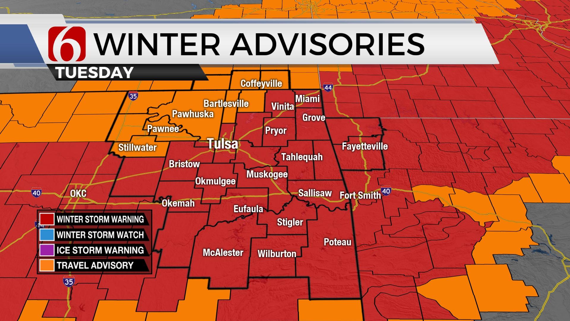
A powerful upper-level system will bring impactful wintry weather across most of the state today and tonight before exiting early Wednesday morning. Regarding northeastern and eastern sections of the state, most precipitation will start as rain before transitioning to snow by early afternoon. The track of the upper low is favorable for a swath of heavy snow south of I-44 and along I-40. Winter storm warnings are currently in place for those areas more likely to receive the heaviest snow with winter weather (travel) advisories posted for areas expecting lower amounts. The Tulsa metro is currently under a winter storm warning. Locations along the OK-KS state line region are under a winter advisory. Winter storm warnings are posted along both sides of I-40 and extend from east central OK to northwestern Arkansas. Winter warning areas could see between 4 to 6 inches of snow with some locally higher amounts. Winter weather advisory areas may see snow from 1 to 3 inches. Periods of moderate to heavy snowfall rates will be likely with this system later this afternoon and evening. The key to the accumulation forecast remains the exact track of the cold core low and how long rain remains before transitioning to snow. Rainfall lasting longer than anticipated will reduce some of the accumulation forecast. Additionally, some melting at the surface will occur in lighter snow bands.

The temperature profile needed for wintry weather is not expected to develop across most of our area until this afternoon. This means periods of rain will be increasing from the southwest to northeast this morning with temps in the mid to upper 30s. As the upper-level system nears, much colder air aloft will reach the very lowest levels (column cooling) and rain will begin transitioning to snow. The snow is highly dependent on the temperature profile. The confidence level of this system continues to remain quite low, even this morning, especially for the northern sections where rain may linger longer than anticipated. Because of this uncertainty, additional chances to the snowfall accumulation forecast is still possible later today. The entire system will exit early Wednesday. Temperatures will remain chilly Wednesday but will go above freezing into the upper 30s and lower 40s for afternoon highs. Temps will reach the mid-50s Friday and upper 50s Saturday before the next strong cold front rolls across the area late Saturday evening. This will bring arctic air across the state. There will be a window for some precipitation directly behind the front as it passes the area late Saturday night and early Sunday morning. I'll have more about this front and the arctic air tomorrow.

Thanks for reading the Tuesday morning weather discussion and blog.
Have a super great and safe day.
Alan Crone
KOTV

Get The Daily Update!
Be among the first to get breaking news, weather, and general news updates from News on 6 delivered right to your inbox!
More Like This
January 24th, 2023

June 21st, 2023

June 19th, 2023

June 13th, 2023
Top Headlines

December 12th, 2024

December 12th, 2024
December 12th, 2024

December 12th, 2024