Wednesday Morning Update
Strong to severe storms will be a possibility today, tonight, and early Thursday morning across part of the area. Highs today will be in the 70s with strong south winds. Colder air arrives early ThursdayWednesday, April 17th 2013, 5:43 am
Strong to severe storms will be a possibility today, tonight, and early Thursday morning across part of the area. Highs today will be in the 70s with strong south winds. Colder air arrives early Thursday midday through the afternoon.
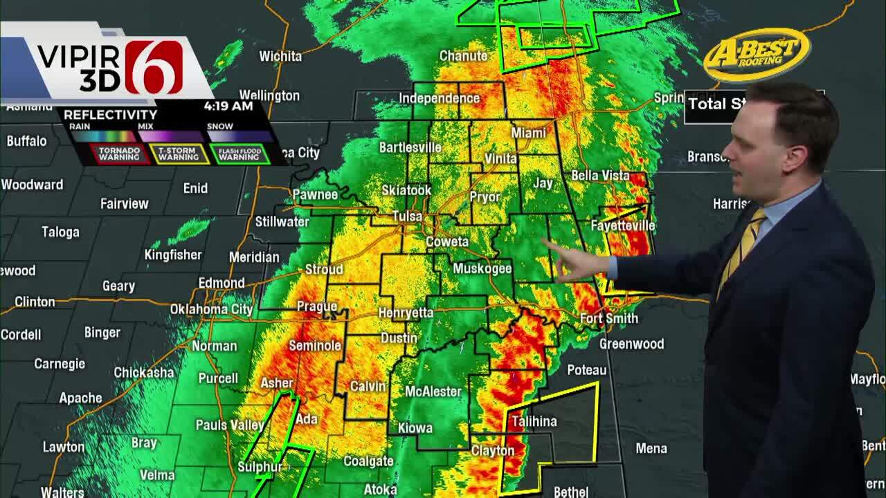
The stationary front that has been south of the Tulsa for the past two days is now slowly lifting northward as a warm front. This morning this boundary is still south of I-40 at 4am. Warm and moist air will begin flowing northward along with gusty south winds as a strong upper level system approaches the area. This will set the stage for some strong to severe storms across the state, including the possibility of severe weather. The SPC continues to highlight a MODERATE risk of severe storm production across a small part of Northern TX, a large portion of central and northeastern OK and a small part of SE Kansas. There continues to be some differences in model output regarding the exact location of certain severe weather parameters. Regardless of these differences, residents across the state should remain aware of the weather today and tonight regarding the severe weather potential.
Most data does not bring the actual cold front back across the area until early Thursday morning. This means storm formation in the warm sector could occur this afternoon into the early evening hours, but the favored window of opportunity will continue to late tonight into pre-dawn Thursday for most of eastern OK. If storms can form this afternoon or early evening east of the cold front and dry line, they would be super cells capable of extremely large hail, damaging winds, and possibly tornadoes. Storms will attempt to form across western OK around the 2pm to 4pm time frame and move into central OK by late afternoon or evening. The higher probability for supercell thunderstorms with this system should occur in southwestern OK into south central OK by afternoon. The higher likelihood for our immediate area is for storms to form along the approaching cold front later tonight, mainly after 11pm into the 4am time period. The main threat at this point would be hail and wind with an embedded super cell in the squall line. Moderate to heavy rainfall could occur in some locations, but the overall fast movement of the system will limit any flash flooding potential. I must also stress the uncertainty of this event due to the eventual position of the frontal boundary this morning. Some HI RES data also suggest some spotty and scattered storms may form this morning across eastern OK which could complicate the pattern even more.
Colder air will move across Kansas and into northern OK by midday Thursday. This means our temperatures Thursday morning will be in the 50s and 60s across eastern OK with readings falling into the lower to mid-40s by the afternoon along with gusty northwest winds. The clouds will also gradually clear from the west to east late in the day Thursday allowing temperatures to drop near Freezing Friday morning near or west of Tulsa. Friday afternoon should feature sunny but cool conditions with highs in the lower or mid-50s.
Saturday should be very nice with morning lows in the upper 30s and afternoon highs in the mid to upper 60s. South winds will be likely this weekend with slightly warmer air Sunday.
Both the GFS and EURO support a weak wave Sunday producing a shower or two, but this chance will remain very low.
The higher probability will be Monday night into Tuesday when another strong cold front will move across the state bringing another round of potentially strong to severe storms followed by another cold air mass by April standards. The long range pattern recognition would continue to support an active weather set up for the next month.
The high in Tulsa yesterday was 57 at 4:08pm.
Our normal daily average high is 72 and the low is 50.
Records include a high of 72 recorded on this date in2006 and the low of28 recorded in 9121.
You'll find me on Facebook and Twitter. https://www.facebook.com/AlanCroneNewsOn6
Twitter @alancrone
I'll also be discussing the statewide and regional weather forecast on numerous affiliates of the Radio Oklahoma News Network through the morning and early afternoon.
I'll be discussing this complex weather set up this morning with Dan Potter and The KRMG Morning News in Tulsa.
Thanks for reading the Wednesday Morning Weather Discussion and Blog.
Have a super great day, but remain aware of the weather this afternoon, tonight, and into early Thursday morning.
Alan Crone
KOTV

Get The Daily Update!
Be among the first to get breaking news, weather, and general news updates from News on 6 delivered right to your inbox!
More Like This
April 17th, 2013

April 15th, 2024

April 12th, 2024

March 14th, 2024
Top Headlines

April 28th, 2024

April 28th, 2024
April 28th, 2024

April 28th, 2024
