Nice Break Thu/Fri, Much Cooler This Weekend
<p>Looking good for a few days, but that will be changing as we get into the weekend.</p>Wednesday, May 11th 2016, 8:51 pm


Another very warm day today with temperatures generally running about 10 degrees above normal this morning and again this afternoon. The normal max/min for the Tulsa area is 78/58 and we should be closer to those numbers for our Thursday.
[img]
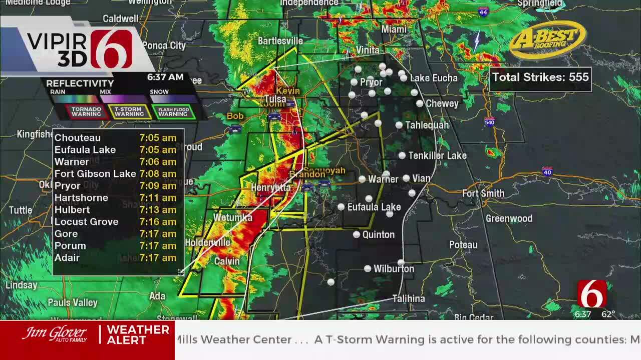
A cool front is moving through the state as I write this and will bring northerly winds along with cooler and drier air for the next few days. The front itself is expected to set off some showers/storms for the overnight hours tonight and some of those may be severe as you can see. So far, a layer of very warm and dry air aloft has prevented any storm formation but as the boundary moves further SE and encounters more moisture there remains that chance.
[img]
As mentioned, that will be followed by a very pleasant couple of days with the northerly winds Thursday dropping our dew point temperatures into the 50s and the relative humidity will be dropping into the 30% range which is rather pleasant for this time of year. Mostly cloudy skies in the morning will give way to abundant sunshine by the noon hour and for the balance of the day. Morning lows will be near 60 and daytime highs in the upper 70s to near 80, so as mentioned at least somewhat closer to normal for this time of year.
That drier air together with clear skies to start the day on Friday will result in morning lows in the lower 50s followed by plenty of sunshine, a return to southerly winds, and daytime highs into the lower 80s that afternoon. Yet another frontal boundary will arrive Friday night but moisture will be lacking so it should arrive dry. However, the boundary is expected to stall out along the Red River or into N Texas and at the same time a series of disturbances aloft will be moving overhead.
As you can see on our forecast page, that means little or no sunshine for the weekend into next week and chances of rain/showers/storms. Right now, it does not appear that the weekend will be a total washout as most of the day Saturday looks to be cloudy with only a slight chance of rain. Better chances are expected for Sunday and Monday and the potential remains for some locally heavy amounts by the time it is all said and done. All of the above also add up to much cooler temperatures for the weekend and to start next week.
[img]
This unsettled pattern may well persist through the following weekend as well as can be seen on the 6-10 day outlook for precipitation. Temperatures during that time frame are expected to be trending closer to normal after the very cool conditions we will have this weekend and early next week.
[img]
[img]
So, stay tuned and check back for updates.
Dick Faurot

Get The Daily Update!
Be among the first to get breaking news, weather, and general news updates from News on 6 delivered right to your inbox!
More Like This

May 11th, 2016

April 15th, 2024

April 12th, 2024

March 14th, 2024
Top Headlines

April 26th, 2024

April 26th, 2024

April 26th, 2024
