Oklahoma Getting Much Needed Rainfall
<p>Our system is underway this morning with broad area of rainfall across the state. The main storm system is currently south of the immediate area and will continue to exit the area from the northwest to southeast later today.</p>Tuesday, February 14th 2017, 4:10 am


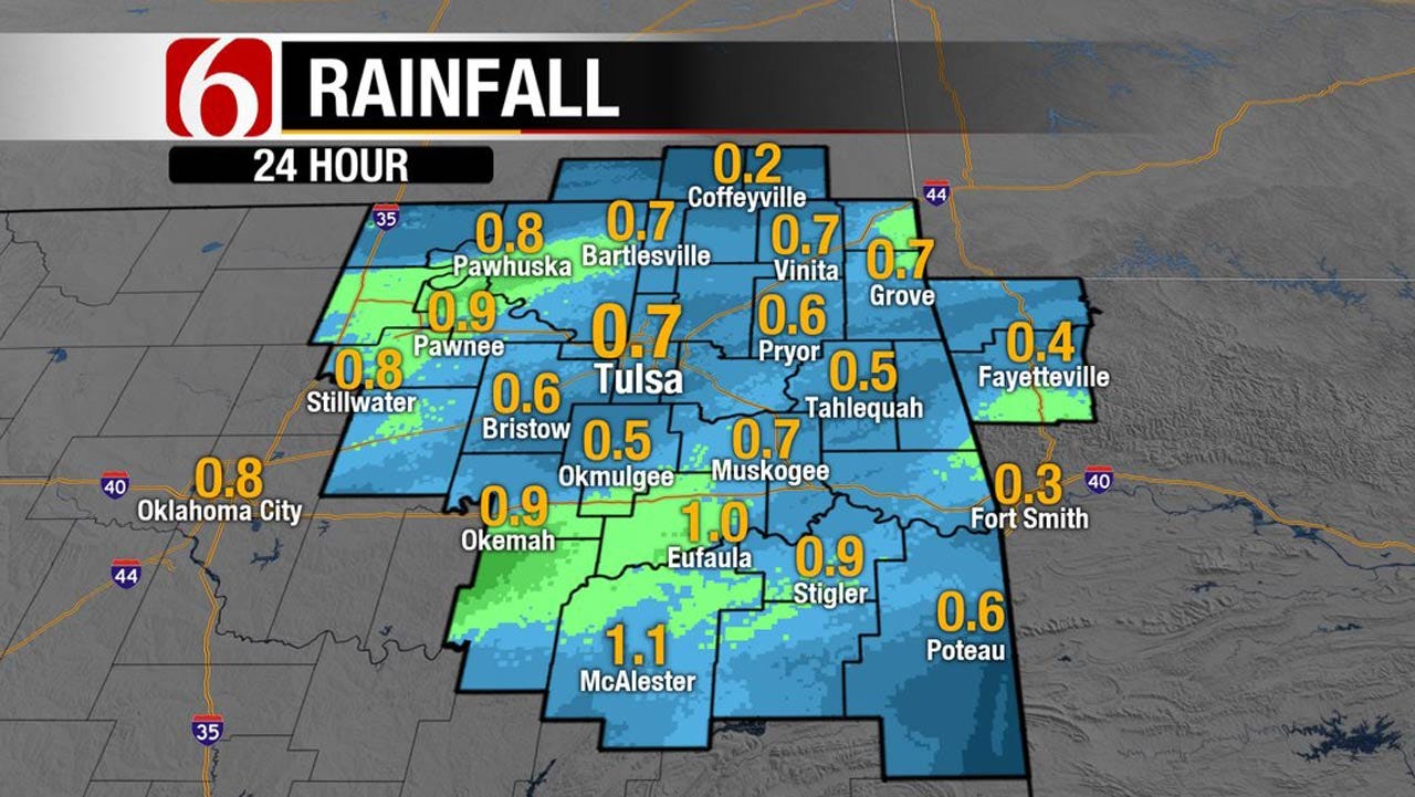
Our system is underway this morning with broad area of rainfall across the state. The main storm system is currently south of the immediate area and will continue to exit the area from the northwest to southeast later today.
We’ll see improving conditions for the north to south later with highs in the upper 40's north and lower 50's south. Our next upper level system will pass the area Thursday night into Friday with no impact on sensible weather. A stronger looking long-wave will be nearing the area Sunday or Monday with a decent chance of showers and storms by Sunday night into sometime Monday. It’s a little too early to pinpoint any severe weather threats for this system, but the pattern could provide a few strong storms if significant low level moisture can return ahead of the system. The odds would keep most of the severe weather threats either on the low side or mostly to our southeast. More on this part of the forecast in a day or two.
The early reports-observations indicate some much needed rainfall occurring across the state this morning. We may end up with .50 to near .75 or so near the metro with some 1 to near 2 inch reports across far southern OK. Most of the southeastern and east-central areas that do receive rainfall will be in the running form some 1 to 1.5 inch totals.
I’m a little uncertain on exactly when the pops should be ending across northern OK this morning. As I post, the back edge is already clearing the Tulsa metro but there may be another small window for some rainfall by midday across the north while some light rain will continue through the morning to midday hours across southern OK before ending around 1 pm to 3 pm.
Stay Connected With The News On 6
Wednesday into the end of the week will feature improving weather with morning lows in the 30s and daytime highs in the 50's Wednesday and into the upper 60's Thursday. We should be in the running for at least upper 60's Friday into the weekend with some locations near 70. Despite the current rainfall across the area, the weather conditions will support a rapid drying with increasing fire danger by Thursday and Friday before our late weekend and early next week storm system nears the state.
Thanks for reading the Tuesday morning weather discussion and blog.
Have a super great day!
Alan Crone

Get The Daily Update!
Be among the first to get breaking news, weather, and general news updates from News on 6 delivered right to your inbox!
More Like This
February 14th, 2017

April 15th, 2024

April 12th, 2024

March 14th, 2024
Top Headlines


April 26th, 2024

April 26th, 2024
