Severe Weather Possible Across Oklahoma Wednesday Night
Oklahoma Weather Forecast: Bookmark this page and refresh it often for the latest forecast and daily updates.Wednesday, May 15th 2024, 9:58 am
TULSA, Okla. -
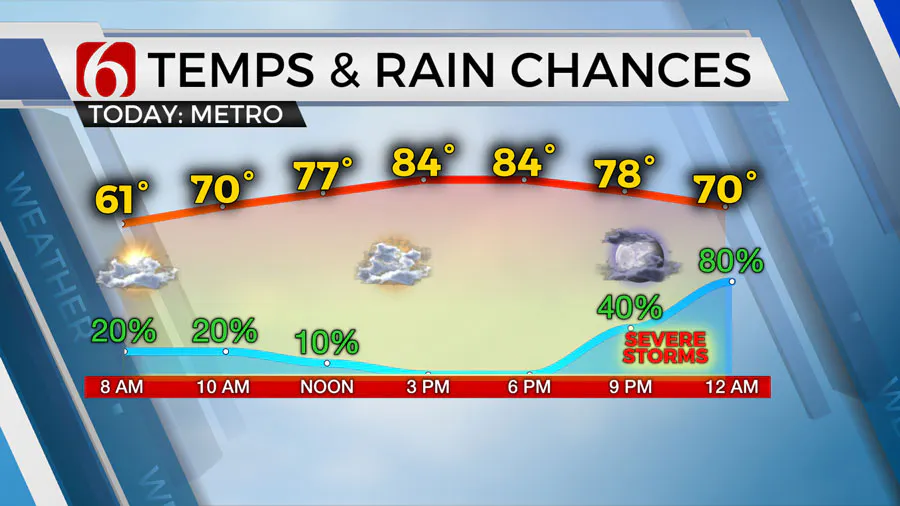
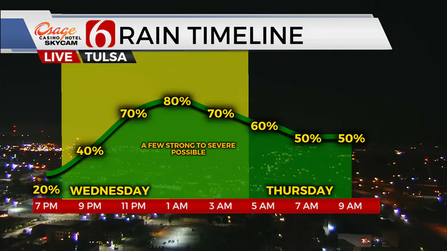
Strong to severe weather is likely Wednesday night in Northeast Oklahoma.
News On 6 will have the latest updates on the storm timeline throughout the night.
What are the chances for severe weather in Oklahoma on Wednesday, May 15?
A period of unsettled weather is likely to produce periodic showers and storms across a large portion of the area Wednesday night through Friday morning.
This will bring increasing rain and thunder chances, including severe weather threats, to parts of the area beginning later Wednesday night across the western half of the state before storms begin migrating eastward into parts of northeastern and eastern Oklahoma.

All modes of severe weather will be possible, with the primary threats of damaging winds and hail. A tornado threat is possible with this system, mostly along and northwest of the I-44 corridor.
Due to antecedent conditions, and the possibility of pockets of moderate to locally heavy downpours, the potential for some low-land and street level flooding will be possible before ending as the last wave in this current series moves out of the area Thursday night late into early Friday morning.

Based on the current timing, most of Friday afternoon and evening should be precip free with mostly pleasant conditions.
What will the weather be like this weekend in Oklahoma?
This weekend some midlevel ridging should nudge northward from part of Texas into most of Oklahoma bringing dry weather, some sunshine, and highs into the mid and upper 80s both days.
South winds will continue to transport low-level moisture into the state resulting in increasing humidity values. Some minor heat index values should occur allowing values into the lower 90s.
The top-edge of the ridge positioned across far northern OK and southern Kansas may still allow a weak boundary to slide southward and stall Sunday into Monday where a complex of storms will be possible during this period.
Early next week, most data support the return of a stronger developing upper-level trough arriving from the southwest. This pattern coupled with climatology supports mentions of more spring severe weather opportunities nearing the region. As we draw closer to next week, we’ll offer more specifics regarding timing and locations.
Outages Across Oklahoma:
Northeast Oklahoma has various power companies and electric co-operatives, many with overlapping areas of coverage. Below is a link to various outage maps.
Indian Electric Cooperative (IEC) Outage Map
Oklahoma Association of Electric Cooperatives Outage Map - (Note Several Smaller Co-ops Included)
The Alan Crone morning weather podcast link from Spotify:
https://open.spotify.com/episode/5j0ovActG8BZCOTqZQzrfU
The Alan Crone morning weather podcast link from Apple:
https://podcasts.apple.com/us/podcast/weather-out-the-door/id1499556141?i=1000646589555
Follow the News On 6 Meteorologists on Facebook!

More Like This
May 15th, 2024
May 15th, 2024
May 15th, 2024
Top Headlines
May 15th, 2024
May 15th, 2024


