Dick Faurot's Weather Blog: Rain At Last; Turning Cooler
The long anticipated rains have arrived for tonight, will be tapering off on Friday with another chance early Saturday morning. Also, more seasonal temperatures will finally be returning.Thursday, October 22nd 2015, 8:51 pm
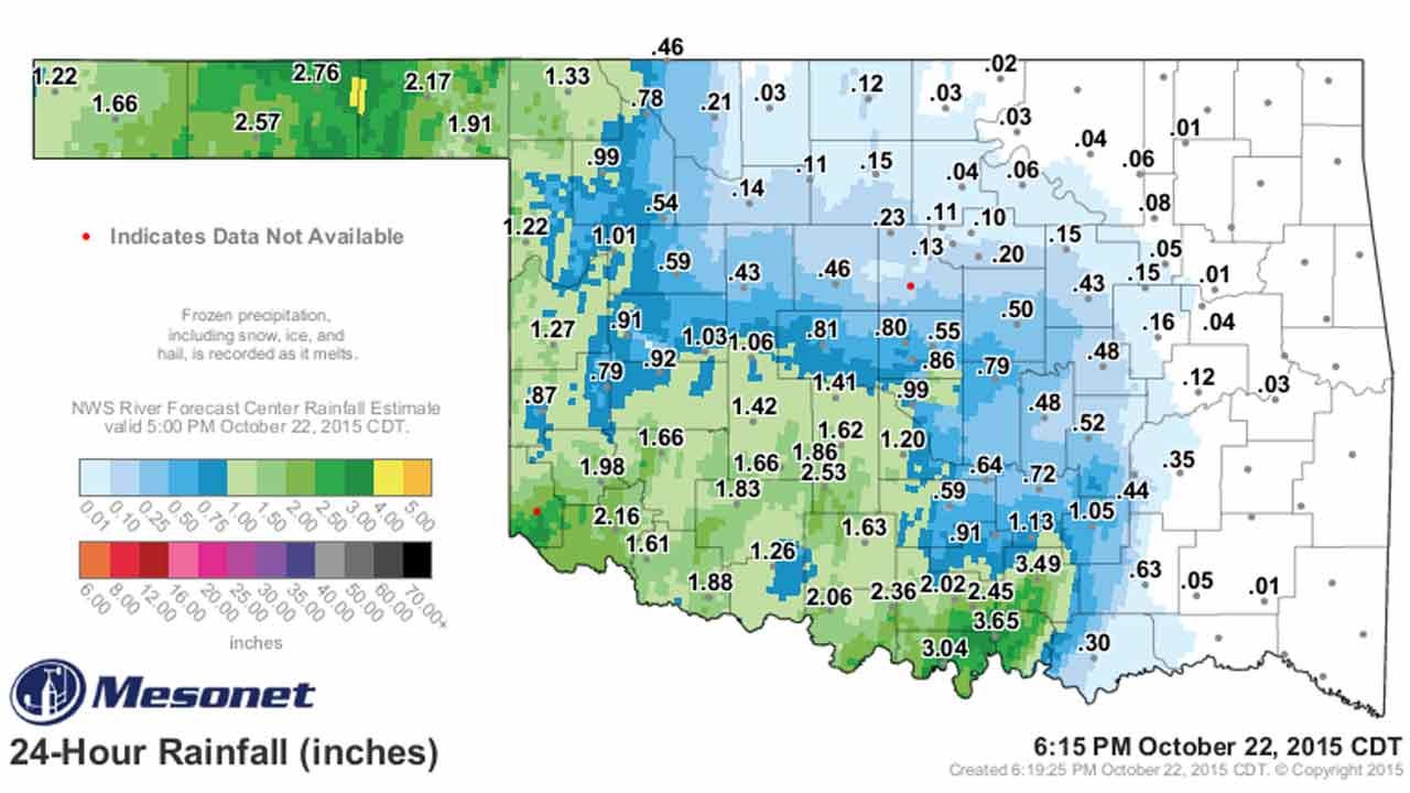


The widespread rains we have been anticipating for days now is currently spreading over Green Country as I write and has already dropped some generous totals for our western neighbors.
Notice the 24-hour totals as of late this afternoon, courtesy of the OK Mesonet, and you can see this system has produced a good soaking, and it has been widespread.
Now that the rains have arrived, they will be with us off and on through the overnight hours and into the morning of our Friday. The showers will be gradually shifting on SE as we go through the day Friday with the showers largely confined to the more E and SE counties by afternoon and evening. By the time the Friday football games roll around, most of the rain should have shifted further to the SE, although there will be a slight chance of some sprinkles or perhaps a brief shower just about anywhere.
Rainfall totals for Green Country do not look to be as generous as what our western neighbors received, with most locations receiving anywhere from ½ to 1 inch of rain for the NE counties and heavier totals for the more SE counties. Quite frankly, that is where it is more desperately needed.
The upper-level system responsible for these showers does not have a surface reflection, so we will keep a S or SE surface wind and continued mild temperatures through the day Friday.
A surface cool front will finally arrive during the early morning hours of Saturday, which will have another good chance of showers and perhaps some thunder, but that system will be quickly moving on to the SE.
Most of the rain should have ended by Saturday morning, but a slight chance of some sprinkles or a few lingering showers will be possible just about anywhere through the morning hours and perhaps into the afternoon as well. For the most part, that should set the stage for some pretty good football weather for the college games on Saturday across the state.
As you can see on our forecast page, there is only a very slight chance of a shower or two Sunday morning and the next chance of rain after that will be on Tuesday. Again, the longer range guidance has not been particularly consistent from run to run or model to model, but a stronger cool front looks to be arriving that night or early Wednesday. That will be followed by an even more significant cool-down going into the latter part of next week.
In fact, as you can see on the 6-10-day outlooks, temperatures are expected to average below normal going through the Halloween weekend, and we may see another chance of rain over the Halloween time frame as well. Again, those details are yet to be worked out, but the trends are certainly there.
In the meantime, stay tuned and check back for updates.
Dick Faurot

Get The Daily Update!
Be among the first to get breaking news, weather, and general news updates from News on 6 delivered right to your inbox!
More Like This

October 22nd, 2015

April 15th, 2024

April 12th, 2024

March 14th, 2024
Top Headlines


April 25th, 2024

April 25th, 2024

