Active Weather Brings More Storm Chances
Oklahoma Weather Forecast: Bookmark this page and refresh it often for the latest forecast and daily updates.Wednesday, May 1st 2024, 9:54 am


TULSA, Okla. -
A weak boundary has shifted from southern Kansas into northern OK with an area of scattered showers and storms along both sides. An outflow has also been generated due to these storms and is located near I-40 with a few scattered storms remaining during the early morning hours.
These storms have been producing heavy rainfall during the overnight hours but are expected to quickly diminish Wednesday morning. The front near the state line should retreat northward as a warm front extending into the central plains by afternoon.
Road Closures Due To Weather
Murray County
- All lanes of east and westbound SH-7 are closed between Woodruff Rd. and US-177 in Sulphur due to severe weather clean-up
- All lanes of north and southbound US-177 are closed between Lawton Ave. and Denney Rd. in Sulphur due to severe weather clean-up
Drivers are urged to avoid the area. For drivers who cannot avoid the area, a local detour is in place.
| What will the weather be like in Oklahoma on Wednesday, May 1? |
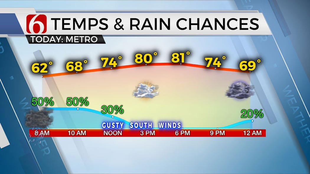
We’ll see gusty south winds from 15 to 30 mph with highs reaching the upper 70s and lower 80s Wednesday afternoon with a few clouds and sunshine returning.
Stronger mid-level flow will quickly move across the Midwest, but another lobe of energy also arrives from the west generating additional storm chances later Wednesday afternoon and evening along and east of a dry line across western OK while more storms form along the frontal boundary located across Kansas.

Severe threats will return across the western half of the state Wednesday evening. Both areas of storms will gradually expand eastward with some scattered storm chances arriving near our area later tonight into early Thursday morning.
The threat of severe storms will be greater across the far western sections of the state but a few strong to near severe storms will be possible overnight into early Thursday as they migrate eastward.
What are the storm chances in Oklahoma on Thursday, May 2?
Thursday morning there may be two batches of storms. One larger area is expected across southeastern OK along the Red River Valley, Texoma region, extending into part of northern Texas. Another area is possibly far northern OK. Higher chances remain to the south, but we’ll keep a decent mention near northern OK for early Thursday morning.

As the front progresses southeast, additional storms are likely to develop by afternoon and evening. The upper air flow will be relatively weak but some strong to severe storms will remain possible Thursday.
A mitigating factor will be the storms along the Red River Thursday morning. If these last longer than anticipated, the moisture flow into the developing frontal boundary will be disrupted.
Storm chances will remain regardless of this scenario but the threat of strong to severe storms may be mitigated Thursday.
What will the weather be like this weekend in Oklahoma?
As the front moves southeast, we’ll see a minor break in storm activity Friday with morning lows in the upper 50s and afternoon highs reaching the mid to upper 70s with north winds from 15 to 25 mph.
This front is expected to stall and begin lifting northward Saturday as another wave approaches from the west.
We’ll expect a few showers and storms developing late Friday into the overnight periods into early Saturday with this process.
Higher chances for storms should also arrive early Saturday morning as a storm complex is likely to develop across southwestern Kansas Friday night and track into part of northern OK Saturday.
Additional storm chances will return Sunday into Monday, a much stronger upper-level trough is likely to approach the region from the southwest.
What will the weather be like next week in Oklahoma?
Storm chances are likely to return for part of Sunday with gusty south winds and highs in the mid to upper 70s. A few of the storms may be strong to severe Sunday with higher threats across the western half of the state.
By Sunday evening into Monday, a powerful upper-level trough is drawing closer to the state and will be increasing some severe weather parameters Monday. The system may also encounter an increasing layer of warm air aloft that may initially suppress some storm activity early to midday Monday.
By Monday late afternoon and evening, strong to severe storms will be possible as lift from the system is maximized. Some changes are likely to this portion of the forecast and will be refined in the coming days.
Outages Across Oklahoma:
Northeast Oklahoma has various power companies and electric co-operatives, many with overlapping areas of coverage. Below is a link to various outage maps.
Indian Electric Cooperative (IEC) Outage Map
Oklahoma Association of Electric Cooperatives Outage Map - (Note Several Smaller Co-ops Included)
The Alan Crone morning weather podcast link from Spotify:
https://open.spotify.com/episode/5j0ovActG8BZCOTqZQzrfU
The Alan Crone morning weather podcast link from Apple:
https://podcasts.apple.com/us/podcast/weather-out-the-door/id1499556141?i=1000646589555
Follow the News On 6 Meteorologists on Facebook!


Get The Daily Update!
Be among the first to get breaking news, weather, and general news updates from News on 6 delivered right to your inbox!
More Like This

May 1st, 2024

May 1st, 2024

May 1st, 2024

May 1st, 2024
Top Headlines
May 1st, 2024
May 1st, 2024

May 1st, 2024