Winter Weather Advisory Continues For Wednesday
You'll have snow and sleet as you head out the door this morning.Wednesday, January 22nd 2020, 4:34 am

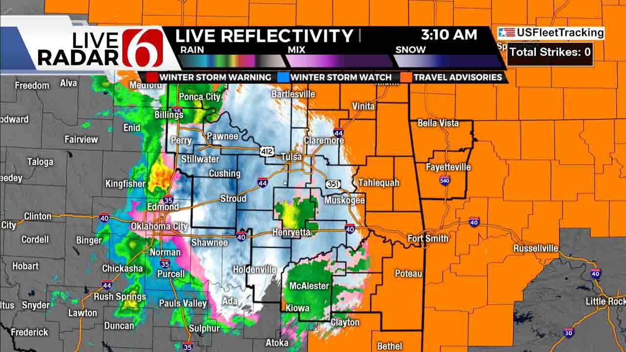
The rain to snow to rain event is underway this morning across eastern OK and southeastern Kansas. A winter weather advisory remains until 3pm for much of eastern OK with some locations across extreme eastern OK and western Arkansas remaining in the advisory through early Thursday morning. Periods of wet slushy snow and rain will be likely across eastern OK with spotty snow accumulations between 0.50 to 1.5 inches. Others will remain just rain. Some travel issues are likely to occur.

Locations slightly east may be a few degrees colder where the snow and rain may freeze on contact with elevated surfaces. Temperatures will be around 32 to 31 this morning from the west to east with afternoon readings mostly in the mid to upper 30s with snow quickly transitioning back to rain ending this morning and ending from the west to east.
WARN Radar
Another small wave will bring some additional rain showers across the area later tonight ending early Thursday morning. Most of Thursday should be dry for most of the area. Another strong upper level trough will dive down the central plains Thursday night into Friday morning bringing snow to the Missouri Valley. Locations on the backside of the low, mostly southeastern Kansas, northwestern Arkansas and southwestern Missouri will experience some light snow early Friday morning well to the northeast of the metro. Locations across extreme northeastern OK from Vinita to Grand Lake of the Cherokees may also get a minor dusting but this chance will remain near 20%. As this system quickly pulls away from the area, improving conditions will occur with above seasonal temperatures into the weekend. We’ll be nearing 60 Monday before our next storm system nears the region for the middle of next week.

The short wave is quickly advancing across the plains this morning with the main vort (disturbance) lifting northeast into Kansas. The precipitation is unfolding this morning as anticipated but we’re still just watching right now to see how the accumulation process completes. This system has been extremely difficult to pin down from a sensible weather standpoint regarding how much wintry impacts can be released. Some quick downbursts of wet snow earlier this morning accumulated quickly. But the expectation of the phase change back to rain also complicates matters even more with how much accumulation on the surface will survive. Additionally, the wet bulb process may lower temps a degree or two past our expectations across east-central OK which would change this process even more for the next hour or so.
Remain aware of your weather surroundings and slow down for the morning to midday commute.
Thanks for reading the Wednesday morning weather discussion and blog.
Have a super great day!
Alan Crone

Get The Daily Update!
Be among the first to get breaking news, weather, and general news updates from News on 6 delivered right to your inbox!
More Like This

January 22nd, 2020

April 23rd, 2024

February 2nd, 2024
January 24th, 2024
Top Headlines


April 25th, 2024

April 25th, 2024

