Windy And Warm Across Eastern Oklahoma
<p>Dew point depressions are not that low at this hour, but spotty drizzle-mist- and some small showers will still be possible for the next few hours as strong southerly flow continues across the area. </p>Friday, November 17th 2017, 3:46 am
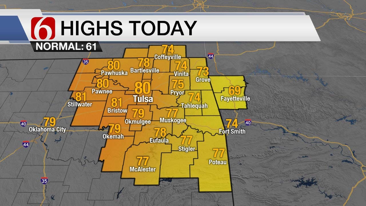
Dew point depressions are not that low at this hour, but spotty drizzle-mist- and some small showers will still be possible for the next few hours as strong southerly flow continues across the area. The stratus deck will more than likely remain through noon and should thin from the west to east by afternoon allowing temps to surge into the upper 70s and lower 80s. If this is the case, we’ll be flirting with some daily record highs in a few spots this afternoon near and west of the metro. South to southwest winds from 20 to 35 mph will be likely today and tonight in advance of a strong front that will blast across the area pre-dawn Saturday with northwest winds from 35 to 40 mph Saturday morning before slowly decreasing by early to late afternoon around 20 mph. Winds tomorrow morning will be near advisory levels for a few hours. Dry air will arrive this afternoon near and west of the I-35 corridor where the local fire danger issues will be increasing. Our fire danger issues across eastern Oklahoma will also increase due to the strong winds both today and even more so Saturday morning.
Temps will drop from the upper 50s and lower 60s pre-dawn into the upper 40s or lower 50s and will remain in the upper 50s late in the afternoon for Saturday afternoon highs. The chance for precipitation with this front is not zero but will be mostly confined to far northeastern Oklahoma-southwestern Missouri and northwestern Arkansas in the form a few showers.
A surface ridge of high pressure will be slightly west of the area Sunday morning with temps near freezing across northern Oklahoma due to the light winds, clear sky and dry air. Daytime highs will be near 60 by the afternoon with a return of a southwest surface wind around 10 to 15 mph. South winds will increase Monday with lows in the 50s and highs in the lower or mid-60s before another front quickly passes the area with a minor yet noticeable cool-down Tuesday into Wednesday with morning lows in the 40s and highs in the 50s. Operational data has converged with a slightly warmer profile for Thursday into the weekend with highs in the 60s for the Holiday before another front nears the area this weekend with a chance for a few showers followed by another cool-down. The ensemble data, however, continues to offer some chilly weather for most of the Thanksgiving holiday period. I’m inclined to keep our current trends of the forecast intact for this forecast cycle.
Thanks for reading the Friday morning weather discussion and blog.
More Like This
November 17th, 2017
September 29th, 2024
September 17th, 2024
Top Headlines
December 15th, 2024
December 15th, 2024
December 14th, 2024


