

Spring Temperatures Monday Before Winter Returns To Northeastern Oklahoma
After a record tying performance yesterday with highs in the mid to upper 70s, we’re still in great shape today with highs back into the lower to mid 70s before reality returns with a strong cold front plowing through the state Tuesday.Monday, February 3rd 2020, 8:34 am
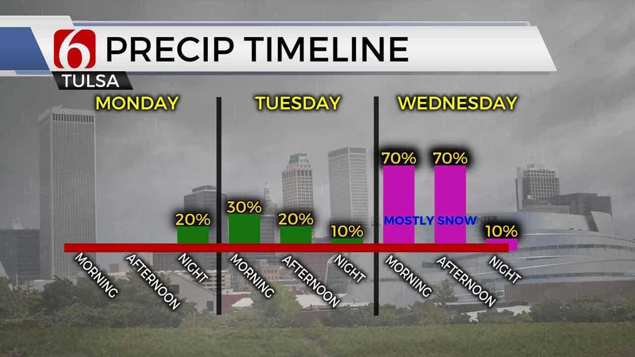
After a record tying performance yesterday with highs in the mid to upper 70s, we’re still in great shape today with highs back into the lower to mid 70s before reality returns with a strong cold front plowing through the state Tuesday morning with falling temperatures followed by a chance of snow and wintry mix across part of the state Wednesday. Some accumulations will be possible. The cold weather will remain in place for the remainder of the week with some modification and improvement in daytime highs Thursday and Friday. A weak front will cross the area Friday with slightly cooler weather into the Saturday before south winds should return Sunday. Additional colder air is likely for next week.

Gusty south winds are likely today in the range of 20 to 30 mph as the surface pressure gradient cranks in response to this developing storm. A strong upper level trough is located across the western U.S in the northern stream with a smaller yet strong disturbance located across the southern stream. Both features will have a role in the next 60 hours with windy weather today before the surface cold front rolls across the area Tuesday morning.

Early this morning low and mid-level moisture is rapidly returning across the plains evident in the observation network. It’s possible that a few small showers or sprinkles may develop this morning across north Texas and move into southeastern Oklahoma, yet the odds will remain low. We’ll have more clouds today compared to yesterday, but the overall temperature profile should remain warm, with highs near the 70s plus or minus a few.

As the cold front nears the state early late Monday night into Tuesday morning, temps across southeastern OK will be in the 50s to 60s where some surface instability will be likely, promoting the growth of a few scattered storms that may produce small hail and gusty winds. These storms are not expected to be severe but will eventually become severe across the regions slightly southeast of the state Tuesday, with daily severe weather chances across the southeastern U.S. into the week as the storm system advances into these regions.
Temperatures near the metro will be in the upper 30s or lower 40s Tuesday morning but will drop into the mid-30s by the afternoon with north winds and blustery conditions. While a few showers will be possible, Tuesday will mostly be uneventful from a big weather standpoint, other than falling temps.

Tuesday night into Wednesday, the northern stream system phases with the southern disturbance creating favorable lift for moisture to be lifted and over the colder air at the surface resulting in snow and wintry mix somewhere across the state. The first look at data suggests the column of air will be cold enough from the top to surface for all snow across the northern and central part of the state with some mix across southern OK. The actual location of the potential snow will continue to be defined but currently includes locations across the I-40 corridor into the I-44 region. A winter storm watch has already been posted for a large portion of southwestern OK into central sections of the state. There are no watches or advisories for our immediate area as of this morning.
Temperatures Wednesday should start in the mid to upper 20s and finish with highs in the lower to mid-30s. Once this system exits the area Wednesday afternoon and evening, we’ll be mostly quiet through the end of the week.
The timing of the system currently suggests that both the Wednesday morning commute and evening hours may be impacted by some wintry weather.
Thanks for reading the Monday morning weather discussion and blog.
Have a super great day!
Alan Crone

Get The Daily Update!
Be among the first to get breaking news, weather, and general news updates from News on 6 delivered right to your inbox!
More Like This
February 3rd, 2020

November 30th, 2022

November 1st, 2022

August 26th, 2022
Top Headlines

December 15th, 2024

December 15th, 2024

December 14th, 2024
