Chilly Morning With Pockets Of Drizzle
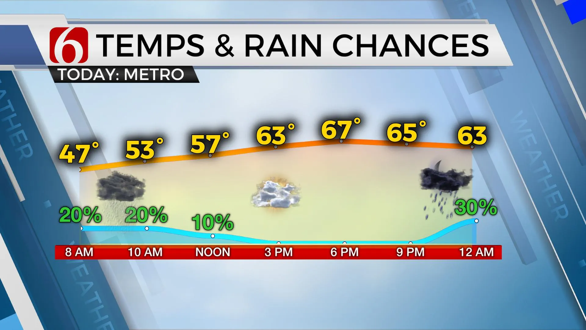
We’re looking for another chilly start along with more pockets of drizzle and even a few showers for the morning hours before relatively warmer and moist air begins lifting northward as our next storm system nears the area.Tuesday, October 20th 2020, 5:40 am
We’re looking for another chilly start along with more pockets of drizzle and even a few showers for the morning hours before relatively warmer and moist air begins lifting northward as our next storm system nears the area. Highs today will be tricky but most locations near and south of the metro will reach the lower 70s with locations near and north of the metro in the 60s. We’re tracking two cold fronts, including a strong front arriving by the end of the weekend.

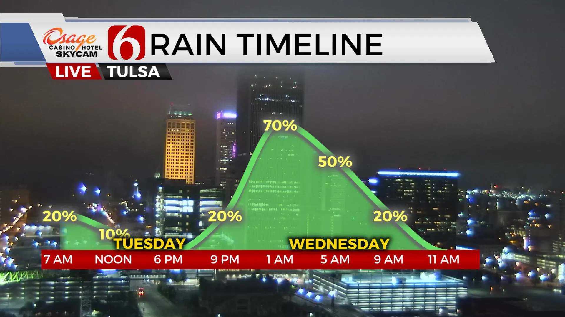
We have some controversy this morning. The front that rolled across the area Sunday is scheduled to retreat northward today as a warm front bringing another chance for mist and showers for the morning hours. The warm front should lift northward and arrive near the OK-KS state line region later this afternoon and evening. Some data suggest this warm frontal intrusion may be slower than originally forecast and would keep the metro and northeastern OK in cool weather for one more afternoon while locations south of I-40 would reach the 70s. I’ve basically kept some forecast trends from yesterday and will bring the lower to mid-70s into southern OK, but keep the metro in the 60s. This means storm chances tonight would be more probable across and north of the I-40 corridor, including the metro region, as the pressure continues falling and eventually pulls the front north. This will eventually bring warmer weather, back into the 80s across northern OK Wednesday and Thursday. But the warm-up will be brief.
Later Thursday night into early Friday morning, the first of two strong cold fronts arrive. This first boundary brings a few storms early Friday morning with temps starting the upper 60s or lower 70s but falling into the lower 40s by afternoon with strong north winds. This cooler weather should remain Saturday with lows in the 40s and highs in the mid-50s as north winds remain for most of the day. But late Saturday night into Sunday morning south winds briefly return and temps move into the mid or upper 60s pre-dawn Sunday before a significant cold front plows across the state either Sunday morning to midday with falling temps and strong north winds. This system will bring dynamic energy to the plains with showers and storms near or behind the front. As if looks now, severe weather threats would be maximized east of the state early next week.

But this system also brings much colder weather down the intermountain region into the plains and could bring the first freeze of the season into the plains early next week. Some data has been hinting at wintry weather across northwestern OK Monday as the upper airflow will be positioned to bring moisture up and over the colder air near the surface. This is something that could produce some wintery weather across the plains if the air remains cold enough. Stay tuned.
Thanks for reading the Tuesday morning weather discussion and blog,
Have a super great day!
Alan Crone
Check our my podcast “ Weather Out The Door” on most podcast providers, or you can find the SoundCloud link here.
More Like This
October 20th, 2020
February 14th, 2022
January 26th, 2022
January 25th, 2022
Top Headlines
December 14th, 2024
December 14th, 2024
December 14th, 2024
December 14th, 2024


