Winter Storm Warning Issued For Osage, Kay Counties (8pm Update)
A rollercoaster pattern kicks off on Wednesday as the potential for storms and some winter weather moves into Green Country.Wednesday, February 16th 2022, 8:38 pm


TULSA, Oklahoma -
Update: Winter Storm Warning for Osage and Kay County in OK until 6:00 pm Thursday.
A rollercoaster pattern kicks off on Wednesday as the potential for storms and some winter weather moves into Green Country.
Related Story: ODOT Making Preparations For Possible Winter Weather
Related Story: Quapaw Public Schools Cancels Thursday Classes Ahead Of Forecasted Winter Weather
Details from News On 6 Meteorologist Stephen Nehrenz:
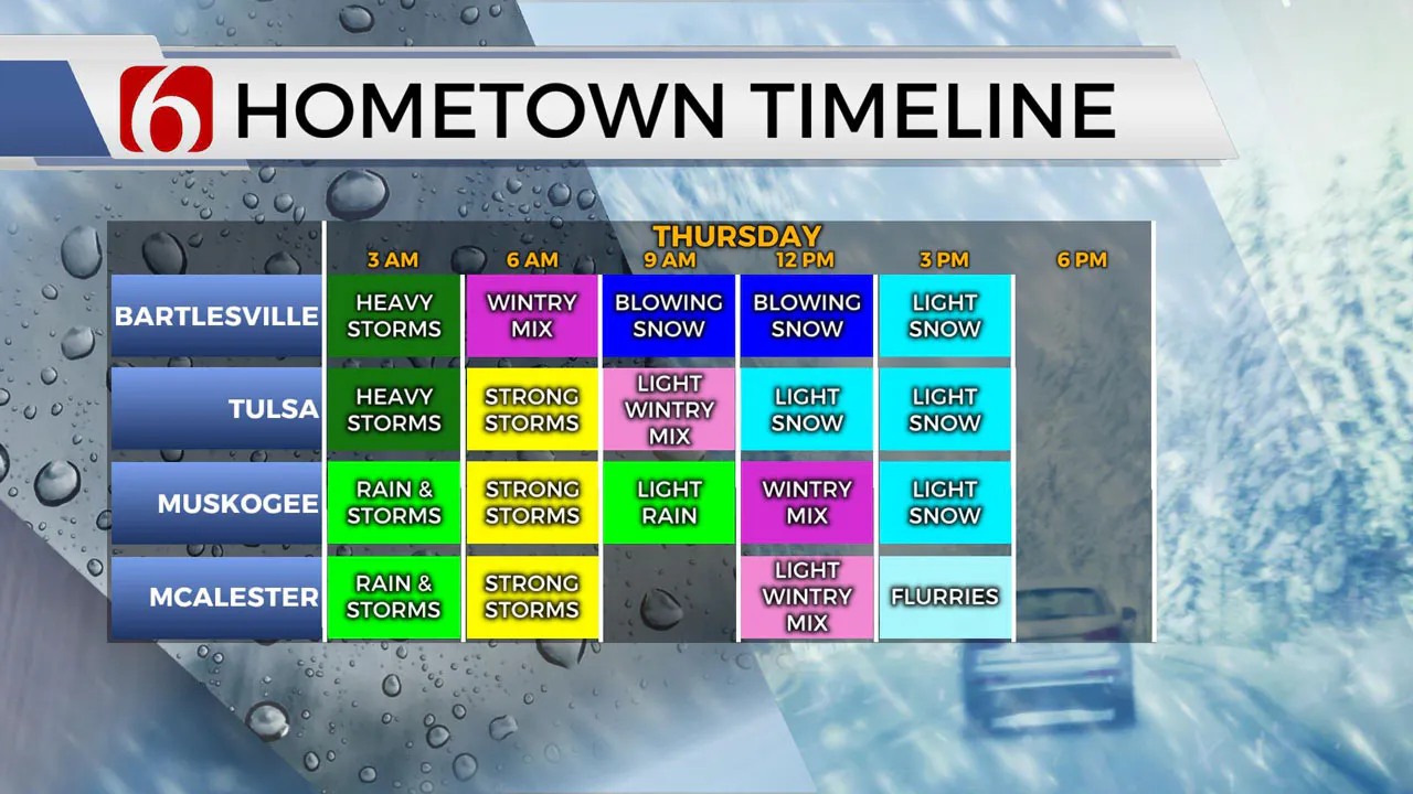
Rain and storms are expected Wednesday night into early Thursday morning. A few strong to severe storms could be possible south of Tulsa. At the same time, colder air will be surging in for the northern counties and rain will transition into freezing rain and snow. Snow will shift south and east during the afternoon. Snow accumulation will be more likely north of Tulsa where travel advisories and winter storm warnings are in effect. Temperatures will be plummeting through the day and wind chills will be in the low teens or single digits by Thursday late afternoon.
As strong storms shift east in the morning, the cold air surges in.
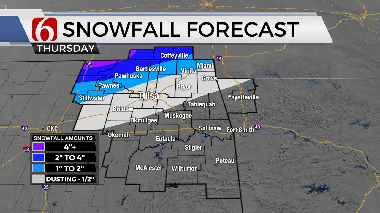
A "sleet to snow" changeover happens before sunrise along the OK/KS state line and the main wave of snow will then shift across our far northern counties from mid-morning through early afternoon. Some of the snow near the OK/KS line will be locally heavy, and with north winds gusting 30-40 mph visibility could be very poor and travel would be quite difficult for a few hours.
Some sleet and snow may reach Tulsa and the I-44 corridor from mid-morning into early afternoon, but the precipitation rate will be lighter than further north, and warmer ground temperatures will limit accumulation around Tulsa and I-44. It'll be a sharp gradient towards heavier accumulations from northern Osage County into SE KS.
You can follow Meteorologist Stephen Nehrenz on Facebook HERE.
Here are the details from News On 6 Meteorologist Alan Crone:

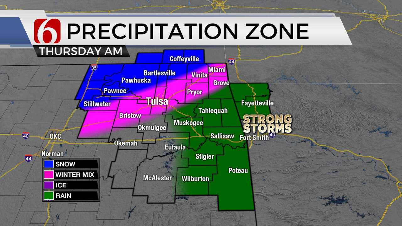
Strong southerly flow remains ahead of the developing cyclone that will bring thunderstorm chances into the area late Wednesday night and exiting early Thursday morning as another strong cold front moves into the state. A few of the storms overnight may be strong to severe. The primary concern will be hail and wind across the northern third of the area. Locations along and south of I-44 could experience all modes of severe storms, including the threat for tornado or two embedded within a segment of thunderstorms. As the system exits Thursday, colder air arrives from the north. The potential for snow will remain in a narrow zone from northwestern OK to southern Kansas, where some significant snowfall is possible. Locations along the state line have the best chance for some accumulating snowfall, but due to forecast uncertainty in some of the data, we'll also need to keep some mentions for snow near the Tulsa metro, along and northwest of I-44. Strong north winds are likely Thursday from 20 to 40 mph. Any snowfall along the OK-KS state line region could result in near white-out conditions due to the presence of strong north winds. A winter storm watch is posted for Osage County Thursday.

Most of the day will be capped to any thunderstorm activity, but some showers or small areas of drizzle will be possible. Highs on Wednesday afternoon will reach the mid to upper 60s, near 70 with south winds at 20 to 40 mph. Later on Wednesday night, the main upper-level system nears the state and stronger winds aloft move over the area. A surface area of low pressure will move across the Red River Valley before turning northeast and moving into NW Arkansas Thursday. Locations along the surface low, mostly along and southeast of I-44 Valley, will have the greater chance for strong to severe storms. The window for strong to severe storms will occur from midnight to 5 a.m. near northern OK and from midnight to 9 a.m. across southeastern OK. Pockets of moderate to heavy rainfall will also be possible across eastern OK with this event that may lead to some river and stream flooding issues Thursday and Friday.

As the surface low lifts northeast, a swath of precipitation is likely along the north and northwest side of the low. As colder air arrives, it will quickly transition to mix and eventually snow. The data continues to be inconsistent with the placement of some heavy snow potential, but our forecast continues to keep this area across far northern OK and southern Kansas. Any shift southward in the data could easily bring a heavy snow band across northeastern OK midday to early Thursday afternoon. Strong north winds from 25 to 45 will also produce blizzardlike conditions along the state line region into southern Kansas.

Another issue will be falling temps from the lower 40s Thursday morning into the mid-20s by afternoon. After a cold Friday, however, the air mass quickly modifies and brings pleasant weather this weekend with highs in the 60s. Another strong-looking system will be near the state early next week with another chance of storms followed by wintry weather threats.

Thanks for reading the Wednesday morning weather discussion and blog.
Have a super great day!
Alan Crone
KOTV
If you’re into podcasts, check out my daily weather update below. Search for NewsOn6 and ‘Weather Out The Door’ on most podcast providers, including Spotify Stitcher, Tune-In and down below on Apple.


Get The Daily Update!
Be among the first to get breaking news, weather, and general news updates from News on 6 delivered right to your inbox!
More Like This
February 16th, 2022

June 21st, 2023

June 19th, 2023

June 13th, 2023
Top Headlines

May 3rd, 2024


May 3rd, 2024
