A Weekend System Before Next Heat Wave
Oklahoma Weather Forecast: Bookmark this page and refresh it often for the latest forecast and daily updates.Friday, July 26th 2024, 6:43 pm
TULSA, Okla. -
The approach of a weather system nearing our area will result in a sunshine-cloud mix on Friday and more clouds on Saturday.

What is the weather like on Friday?
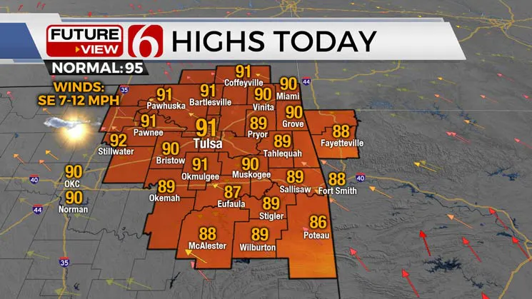
Hazy skies are likely due to the influence of some smoke from Canadian wildfires that arrived earlier this week and the presence of some upper tropospheric dust from the Sarhan dust layer. This is expected to keep temperatures slightly cooler than recent days, with afternoon highs reaching the lower 90s today and into the upper 80s Saturday.

A weak upper-level low will move from the ArkLaTex region into western Arkansas within the next 36 hours. This system will bring a few showers or storms into southern and far eastern Oklahoma on Saturday. Most data indicate this precipitation will remain east of the Tulsa Metro, but we’ll continue to mention the possibility for the metro in case the system slides slightly more west than anticipated.
By early Sunday morning, this wave will move eastward, and a mid-level ridge of high pressure will extend from the western United States into the Southern Plains. This marks the start of a prolonged period of excessive heat and humidity expected to last through most of the next week.

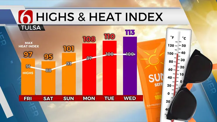
The core of this ridge may stay slightly away from our area, but its influence will result in very hot conditions. The combination of increasing low-level moisture along with local evapotranspiration rates will cause heat index values to range from 105 to 110 Monday and from 108 to 115 Tuesday through Thursday. The ridge may flatten and slide southeast next Friday allowing a northwest upper flow next weekend. This would be favorable for another heat reduction and some scattered storms.
EMSA HEAT SAFETY TIPS:
- PRE-HYDRATION is key in preventing heat-related illness. Drink plenty of water or electrolyte replacement drinks several hours before and during long exposure to the summer heat.
- Wear light-colored, loose-fitting clothing and a wide-brimmed hat if working outdoors, and take plenty of shade breaks.
- No alcohol or caffeine.
- If you do not have air conditioning, find a cooling station or public space (such as libraries or malls) during the day.
- Don’t limit your use of air conditioning.
- Use the buddy system if working outdoors and check on elderly neighbors.
- Keep a cell phone on you at all times when outdoors, including walking, running daily errands, yard work or sports and physical activity.
Outages Across Oklahoma:
Northeast Oklahoma has various power companies and electric co-operatives, many with overlapping areas of coverage. Below is a link to various outage maps.
Indian Electric Cooperative (IEC) Outage Map
Oklahoma Association of Electric Cooperatives Outage Map - (Note Several Smaller Co-ops Included)
The Alan Crone morning weather podcast link from Spotify:
https://open.spotify.com/episode/03KuCPYyb4hNFyC42Yo6Bt
The Alan Crone morning weather podcast link from Apple:
https://podcasts.apple.com/us/podcast/weather-out-the-door/id1499556141?i=1000656145416
Follow the News On 6 Meteorologists on Facebook!

More Like This
July 26th, 2024
July 26th, 2024
Top Headlines
July 26th, 2024
July 26th, 2024


