Storm Chances Stick Around
Grab an umbrella before you head out the door, shower chances stick around on Friday.Friday, July 7th 2023, 6:37 am
If you’re into podcasts or in a rush, check out my daily weather update. Search for NewsOn6 and ‘Weather Out The Door’ on most podcast providers, including Spotify, Stitcher and Tune-In, or Click Here to listen on Apple Podcasts.
TULSA, Okla. - Grab an umbrella before you head out the door, shower chances stick around on Friday.
Here are the details from News On 6 Meteorologist Alan Crone:
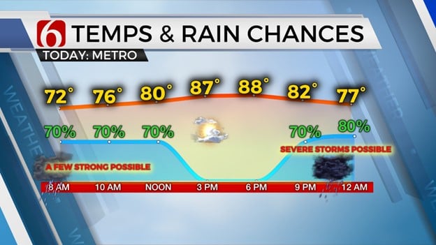
Another organized complex of storms is rolling across part of northwestern and central Oklahoma on Friday morning. The threat for strong and severe storms, mostly in the form of damaging wind and hail, will remain for the next few hours before the complex either exits the area or weakens simultaneously. The exact trajectory of the morning complex may change some, but the overall threat for severe storms currently appears higher to our west and southwest, near the OKC metro. Part of this complex could slide across both sides of the I-40 corridor this morning and near the Tulsa metro region southward this morning. Some additional showers and storms across southern Kansas will slide into northeastern OK but this activity should remain below severe levels. This pattern is tricky, and confidence is somewhat lower than normal regarding exact probabilities for the morning hours. The rest of the afternoon will remain dry but additional storms are likely to move back into the area later tonight and could impact part of northeastern and southeastern Oklahoma overnight with additional severe weather threats. The storm chances and possible severe threats will depend to a certain degree upon how long storms remain this morning across our immediate area. But the overall pattern continues to suggest these late-night and early-morning storm chances will remain this weekend and to some extent into part of next week despite the return of an expanding mid-level ridge nearby. Regardless, we encourage you to remain aware of your weather surroundings both this morning and later tonight.
Temps on Friday will be slightly warmer compared to Thursday with afternoon highs reaching the mid or even upper 80s. The moisture content in the atmosphere supports some minor yet noticeable heat index values in the lower 90s across the southern sections of the state. Another weak surface boundary is expected to move across the area Saturday evening bringing another notable cool-down with Saturday afternoon highs in the mid to upper 80s and Sunday back into the lower to mid-80s.
The mid-level ridge, currently centered to our west, will remain anchored away from the area but will begin expanding the northern periphery into early next week. This will bring exceptionally hot weather into the desert southwest where some locations will be pushing 115 to 120 degrees by the middle of next week. Afternoon highs across NE OK will return into the mid and possibly upper 90s Wednesday through Friday near the metro, but a small window of northwest will remain near northeastern OK despite the increasing ridge. This means we'll continue to be in the running for a few late-night and early-morning complexes rolling across the area. At this point, the signal is supporting decent mentions late Monday night into early Tuesday morning. The ridge may flatten again next weekend with additional storm chances returning.
Thanks for reading the Friday morning weather discussion and blog.
Have a super great day!
Alan Crone
KOTV

Get The Daily Update!
Be among the first to get breaking news, weather, and general news updates from News on 6 delivered right to your inbox!
More Like This
July 7th, 2023

July 12th, 2023

June 26th, 2023

June 15th, 2023
Top Headlines
April 27th, 2024
April 27th, 2024