Heat Stress Arrives Before Additional Storm Chances
Heat Advisories are in effect on Wednesday as the hot summer temperatures continue.Wednesday, July 12th 2023, 5:40 am


If you’re into podcasts or in a rush, check out my daily weather update. Search for NewsOn6 and ‘Weather Out The Door’ on most podcast providers, including Spotify, Stitcher and Tune-In, or Click Here to listen on Apple Podcasts.
TULSA, Okla. - Heat Advisories are in effect on Wednesday as the hot summer temperatures continue.
Here are the details from News On 6 Meteorologist Alan Crone:
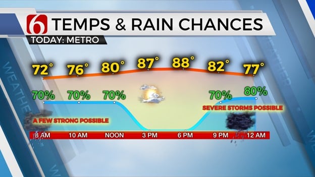
Significant heat stress issues are likely to encompass most of the state on Wednesday and Thursday, with excessive heat warnings across a large portion of the state with heat index values nearing 110 to 116 today and Thursday. Heat advisories will be in effect for counties with indices from 105 to 109. The top-end index will ease some Friday, but still require a heat advisory for most of northeastern Oklahoma. Despite the midlevel ridge expanding across part of northeastern Oklahoma, a narrow northwest flow window will remain parked across the far northern part of the state extending into southeastern Kansas and southwestern Missouri allowing a few storms to impact part of the area over the next few days.
A strong disturbance will drop across the Midwest later tonight bringing another storm complex into the Missouri Valley. The southern edge of this complex will brush far northeastern OK late tonight into pre-dawn Thursday. This system should remain mostly away from the area, but we’ll need to keep some probabilities due to the expansion of possible outflow boundaries Thursday, including the possibility of strong and severe storm activity. The center of the midlevel ridge is expected to move even more westward this weekend with a more pronounced northwest flow developing from southeastern Colorado across the northern third of the state. This should bring another complex nearby late Friday night into Saturday morning across most of the region with some severe weather threats. Another surface boundary is expected to sharpen up some across the central plains and move southward into northern OK by early Saturday and should slowly progress into the southern sections of the state late Saturday night into Sunday. A few additional storms will be likely with this boundary across the southern section Saturday evening into early Sunday morning. This boundary may knock the highs down a few degrees this weekend with a more noticeable reduction in heat index values Sunday. The ridge is expected to expand eastward next week bringing the potential for more heat and humidity with triple-digit readings likely.
Thanks for reading the Wednesday morning weather discussion and blog.
Have a super great day but please remain aware of the increasing heat stress both today and tomorrow.
Alan Crone
KOTV

Get The Daily Update!
Be among the first to get breaking news, weather, and general news updates from News on 6 delivered right to your inbox!
More Like This

July 12th, 2023
July 7th, 2023

June 26th, 2023

June 15th, 2023
Top Headlines

April 27th, 2024

April 26th, 2024

April 26th, 2024

April 26th, 2024
