Halloween Storm Bringing Rain and a November Nose-Dive
Premium fall weather, like our fall foliage seems to be peaking right now. Those that complain we jump straight from summer to winter in Oklahoma need to take note of the recent string of days. At least in 2018, fall has leveled out in a very pleasant range. Of course, all good things must come to an end and there will soon be quite a chill in the air, and not just because Halloween is nearly here. [img] A storm system is arriving here on this Tuesday evening. First, a cold fr...Tuesday, October 30th 2018, 6:11 pm
Premium fall weather, like our fall foliage seems to be peaking right now. Those that complain we jump straight from summer to winter in Oklahoma need to take note of the recent string of days. At least in 2018, fall has leveled out in a very pleasant range. Of course, all good things must come to an end and there will soon be quite a chill in the air, and not just because Halloween is nearly here.
[img]
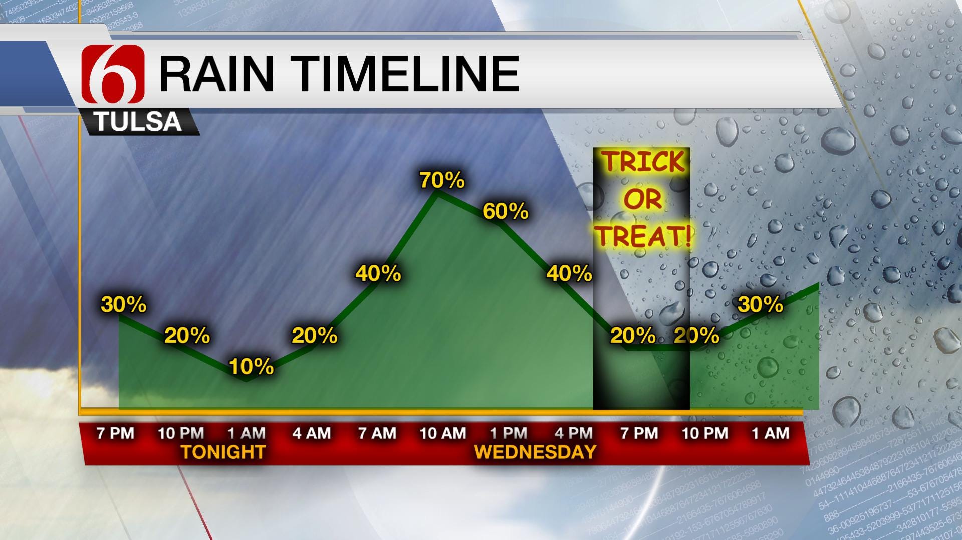
A storm system is arriving here on this Tuesday evening. First, a cold front pushing through the area with a limited opportunity for some rain. Then, the lagging upper-level energy will catch up and generate widespread showers on Wednesday. One more piece of upper-level energy may generate a final round of rain early Thursday before clearing out of Green Country. All in all, this rain won’t be a tremendous soaking. Most of will see a couple tenths of an inch of rain. The exception will be southeast Oklahoma where a steadier, heavier batch of rain is set to fall later tonight and Wednesday closer to the frontal boundary. Above is the rainfall timeline and below are potential rain totals through midweek.
[img]
Behind this front, temperatures will be quick to dip into the 50s. With a driving north wind, it’ll be a cold rain that falls Wednesday in the area. There are indications we’ll see a lull in the activity Halloween night, allowing for ghosts and goblins to roam neighborhoods without umbrellas. However, I’d be prepared for chilly and damp conditions.
[img]
November will start with a string of days featuring cooler than normal temperatures. Highs in the 50s to near 60° and lows in the 40s will be common. A deep trough in the jet stream (shown above) keeps us locked into the cool, somewhat unsettled pattern through the weekend into next week. We may briefly warm up Saturday to near 70° for a high between cold frontal passages. However, you won’t want to part far from your jacket as cooler air arrives early next week and reinforcement of that chilly air occurs a few days later.
So far, we are avoiding a full-on freeze around Tulsa. Our average first freeze date is November 2nd so it could certainly happen anytime based on climatology. It happened on October 29th last year but well into November in 2016. In about a week, a strong cold front could send those readings down far enough for at least a frost. If not then, the outlook for mid-November is cooler than average which could certainly favor a freeze. The obvious pro to having a freeze soon would be to kill some pests. However, the longer we go without a freeze (or a strong wind), the longer we can hang onto our beautiful fall colors.
[img]
For those wanting a forecast for winter, I’ll have to save that for a later blog. We are still compiling our data and predictions on the matter. On November 15th, we’ll have our official Winter Weather Outlook on air so you won’t have to wait much longer.
Until then, enjoy the variety of weather our fall is offering and have a Happy Halloween! Be sure to follow me on Twitter: @GroganontheGO and on my Facebook Page for more updates!
More Like This
October 30th, 2018
September 29th, 2024
September 17th, 2024
Top Headlines
December 11th, 2024
December 11th, 2024
December 11th, 2024


