A Record Setting January, 2017.
<p>A record setting January of 2017, but not the warmest January ever. Cooler air is on the way for the next few days.</p>Tuesday, January 31st 2017, 8:02 pm
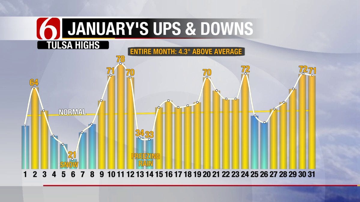
Now that January of 2017 is history, turns out we set a record during the month. No, it was not the warmest January on record, far from it as there are 14 other Januarys that were warmer. But, no other January had as many 70 degree days as we just experienced. January 2017 had a total of 7 days in which the maximum temperature reached 70 or more and that has never happened before. The warmest January on record was in 2006, but there were only 6 days with temperatures at or above 70 that year. Notice the graph which shows how unique January of 2017 was due to the magnitude of the extremes. By that I mean we had a daytime high of 21 followed by a high of 78 just 5 days later; talk about a roller coaster ride!
[img]
So, you are probably thinking with such a warm January, winter must be over….right? Not exactly. As just one example, January of 1989 was much warmer than what we have just experienced, but we had a record snowfall event on March 5, 1989 with nearly 10” on that date. Point is there is still a lot of winter ahead of us with all of February and much of March in which we often receive our heaviest snows.
Today was another example of how extreme this month has been with a morning low of 31 followed by a daytime high of 71; and that was despite a weak frontal boundary that has been draped over the area during the day. Notice on the statewide max/min map, courtesy of the OK Mesonet, how much cooler the more northern counties were as compared to locations along and south of Hwy 412. In fact, a record daytime high was set at McAlester this afternoon.
[img]
For tonight, cooler air to our north will start surging southward with brisk N/NE winds of 10-20 mph by morning and winds of 15-25 or more during the day Wednesday. The cooler air will be gradually filtering our way with morning lows in the low-mid 30s but afternoon highs only reaching the low-mid 50s northern counties and lower 60s for the more southern counties. That means another day with above normal temperatures despite the gusty northerly winds. Keep in mind, those winds will also result in an enhanced fire danger situation.
The much cooler air will really be noticeable for Thursday and Friday as you can see on our forecast page. Although we should still have plenty of sunshine on Wednesday with just some high level cirrus clouds, that will not be the case for much longer. Increasing cloud cover is expected for Thursday, possibly by that morning which makes it questionable whether or not the groundhog will be able to see his shadow and overcast skies are expected by that afternoon, through the day Friday, and also for Saturday.
Despite the cloud cover, any threat of rain should hold off till Saturday into the day Sunday when we will have at least a chance of scattered showers. There is still considerable uncertainty regarding the track and intensity of a system aloft that will be passing over the state by then and which is now out in the Pacific. For that reason, will not get too carried away with the rain chances till we see better continuity from the longer range guidance.
Notice that the 7 day QPF still keeps most of the moisture and heavier rainfall totals east of us with only relatively light amounts for Green Country.
[img]
That weekend system will not have any cold air to work with as temperatures will moderate considerably by Sunday, assuming we get at least some sunshine. Early next week looks to be very mild with potentially some more days with 70 degree readings before much colder air arrives for the middle of next week. However, that cool down looks to be rather short lived as the 8-14 day guidance suggests temperatures above normal once again along with little or no mention of rain.
[img]
[img]
So, stay tuned and check back for updates.
Dick Faurot
More Like This
January 31st, 2017
September 29th, 2024
September 17th, 2024
Top Headlines
December 11th, 2024
December 11th, 2024
December 11th, 2024
December 11th, 2024


