Green Country Braces For Coldest Air In Two Years
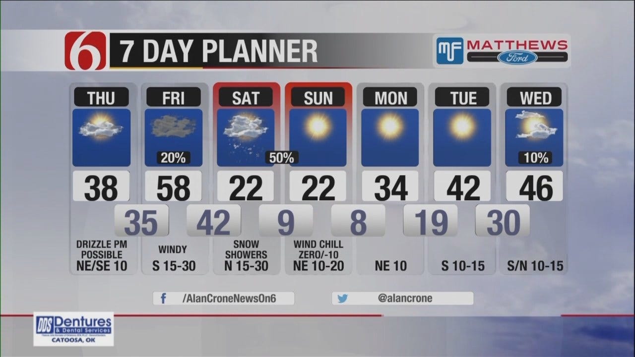
<p>We’re getting ready to experience the coldest air we’ve see in at least two years for the weekend as a powerful cold front will plow across the state Saturday bringing some snow showers, strong north winds, dropping temperatures and very low wind chill values Sunday morning.</p>Thursday, December 15th 2016, 4:22 am
We’re getting ready to experience the coldest air we’ve see in at least two years for the weekend as a powerful cold front will plow across the state Saturday bringing some snow showers, strong north winds, dropping temperatures and very low wind chill values Sunday morning.
Another system may be approaching part of the state by the end of next week but the data continue to offer differing solutions. Our focus of the forecast will be upon the weekend but we’ll have a few issues before we reach Saturday including the chance for some drizzle of mist later tonight into Friday and increasing south winds by Friday midday.
The clouds cleared overnight across part of northern OK and temps dropped into the upper teens and lower 20s along with north winds near 10 mph. This clearing will be quickly replaced with increasing low level clouds moving from southern OK northward by the noon hour.
Just like yesterday, I will include a slight mention for some drizzle or pockets of mist later today and tonight despite the relatively shallow nature of the moisture. As forcing from the western U.S. trough nears the state later today this layer of the atmosphere is expected to see increasing moisture profiles that should support some drizzle developing.
By late tonight into pre-dawn Friday, spotty drizzle and spotty showers will be likely across part of south central and central OK while advancing northeast into southern Kansas.
The main issue with this period will be the surface temperatures across far northern OK where a few spots may still be near freezing Friday morning but the warm air advection pattern will quickly bring these values above freezing and effectively ending any threat of freezing prcip.
As the surface area of low pressure develops and rapidly deepens to our northwest, our south winds will increase speeds from 20 to near 40 mph during the morning to afternoon and rapidly warming temperatures will move from the Mexican plateau into the state by midday and afternoon. Many locations across western and southwestern OK will be in the lower to mid-60s, with upper 50s likely across far northeastern OK by late afternoon and evening.
Some locations, including the metro, may stay in the upper 40s through the afternoon before seeing the 50s Friday night. Temps may continue to rise into the lower 60s after midnight across eastern OK ahead of the quickly southward moving arctic front.
This front will arrive across northwestern OK and southern Kansas around midnight and advance through almost all eastern OK by sunrise Saturday morning. Temperatures Saturday morning will start in the 40s and rapidly fall to the mid-20s by 3pm Saturday afternoon with north winds at 20 to 35 mph. A few storms may develop across far southeastern OK Saturday morning and quickly move into southern Arkansas and northeast Texas. A narrow band of snow will be likely Saturday behind the front and ahead of the main upper trough moving across the central plains.
This band of snow is likely to accumulate across northwestern OK with 1 to 2 inches possible. The band will slide southeast and weaken by Saturday afternoon and early evening but a light dusting of snow will be possible across northern OK with some blowing snow a possibility. This band is expected to weaken as dry air invades the state from the north by evening.
The snowfall forecast may still change but the probability of significant snowfall remains very low. We’re planning to forecast up to 1 inch in some locations across northern OK with slightly higher amounts across southern Kansas.
I continue to think the bigger impact will be the combination of strong north winds and frigid temperatures creating subzero wind chills late Saturday night and Sunday morning to midday.
Model data support temps dropping to near 9F by Sunday morning along with wind chill values from zero to -10 across northeastern OK. Sunday afternoon highs are expected to remain in the lower 20s with decreasing clouds and north winds at 10 to 15 mph.
Light winds and clear sky will result in Monday morning lows in the single digits across northern OK along with wind chill values near 1 to 3 degrees for a few hours. Monday afternoon highs are expected to remain in the lower 30s with Tuesday lows in the teens and highs in the lower to mid-30s.
Thanks for reading the Friday morning weather discussion and blog.
Have a super great day!
Alan Crone
KOTV
More Like This
December 15th, 2016
September 29th, 2024
September 17th, 2024
Top Headlines
December 13th, 2024
December 13th, 2024
December 13th, 2024
December 13th, 2024


