Tornado Watch Issued For Northeastern Oklahoma Counties
<p>A powerful upper level storm system located across the four corners region this morning will bring active weather to the state this afternoon and tonight including the threats for severe thunderstorms capable of producing all modes of severe weather. </p>Tuesday, April 26th 2016, 4:11 am
A "particularly dangerous situation" tornado watch is in effect for much of central Oklahoma and parts of Green Country including Tulsa until midnight.
A powerful upper level storm system located across the four corners region this morning will bring active weather to the state this afternoon and tonight including the threats for severe thunderstorms capable of producing all modes of severe weather. Another storm system will approach the area late Thursday night with another chance of increasing thunderstorm activity Friday into Saturday.
Highs today will be in the lower to mid-80s along with gusty south winds at 20 to 25 mph.
A surface area low pressure will soon develop across far of eastern Colorado and begin moving eastward with a dry line arching southward across part of western or west-central OK into northern areas of Texas. Very strong winds aloft will round of the base of the upper level trough and move across the southern and central plains today. Colder air aloft with this system will gradually spread eastward. These parameters will act to destabilize our atmosphere by this afternoon. Locations along and east of the dry line this afternoon will see increasing thunderstorm chances this afternoon and evening.
Most severe weather parameters will continue to support very large hail, damaging winds, and possibly tornadoes with discrete supercell thunderstorms that form early this afternoon slightly ahead of the dry line.
Storms may form line segments of storms this evening increasing the damaging wind potential. Reports of very large hail will also be possible.
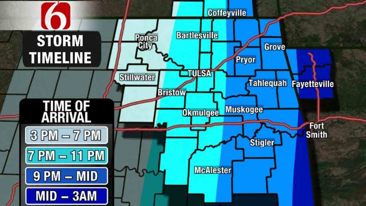
The main window of opportunity for eastern Oklahoma will be from 4 p.m. to midnight with some lingering storms still possible pre-dawn across far western Arkansas. A few storms may persist into the pre-dawn hours of Wednesday, but the latest model guidance suggest storms will exit most of eastern Oklahoma shortly after midnight to 2 a.m.
Stay Connected With Our Free News And Weather Apps
The dry line, however, will remain west of the area through Wednesday midday. Additional thunderstorms will be possible Wednesday afternoon and early evening across part of eastern Oklahoma.
The higher chance for this forecast cycle appears to be across far southeastern Oklahoma and extreme eastern Oklahoma into western Arkansas. If this is the case, the Tulsa metro will be dry Wednesday afternoon and evening.
Thursday appears to offer the best weather day of the week with morning lows in the lower 50s and highs in the mid to upper 70s along with north winds as the surface front associated with our current storm will be south of the state. But another upper level system will quickly influence the state by Thursday night and Friday with additional storm chances.
Thursday night, the front to our south will start lifting slowly northward as a warm front across southern Oklahoma. Locations along this boundary will have a chance of thunderstorm activity including the threat of severe thunderstorm activity.
Additional storms may develop more northward of the front Friday morning across northern Oklahoma and southern Kansas. This may produce some heavy rainfall or hail but would remain elevated in nature.
Check The Latest Watches And Warnings
Friday afternoon the warm front will continue lifting northward with additional thunderstorm chances along the boundary, some of which may be severe. Saturday morning some thunderstorm activity may remain if the boundary hasn’t cleared northern sections. The data remain inconclusive at this hour regarding the position of the warm front for Saturday morning.
We’ll keep the mention of storms in the forecast for Friday and Saturday for this update.
Cooler air will move across the state Sunday and may last for a few days early next week. The pattern may be active to our south and some rain may still be possible.
Please remain aware of your weather surroundings later this afternoon and evening as the threat for severe thunderstorm activity increases across the region.
Thanks for reading the Tuesday morning weather discussion and blog.
Alan Crone
More Like This
April 26th, 2016
September 29th, 2024
September 17th, 2024
Top Headlines
December 12th, 2024
December 12th, 2024
December 12th, 2024
December 12th, 2024


