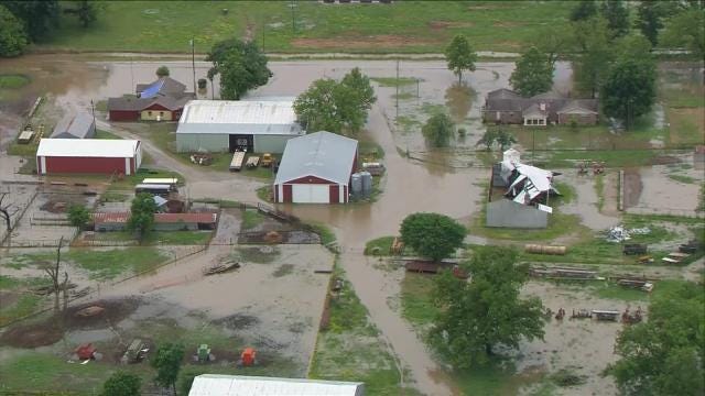
Latimer County Takes Hit From Storm; Flooding Continues In Eastern Oklahoma
Latimer County officials say the Cravens Fire Department was damaged in the storm and trees are down throughout the county. Widespread flooding also has closed roads between Panola and Red Oak.Sunday, May 10th 2015, 9:21 am
By:
Dee Duren
The National Weather Service has canceled a tornado warning that was in effect through 9 p.m. for several eastern Oklahoma counties including Haskell, Latimer and LeFlore counties in Southeastern Oklahoma.
News On 6 storm spotters say a tornado hit the ground for about 50 yards, crossing Highway 2 near Red Oak about 7:30 p.m. on Sunday. Darren Stephens says trees as large in diameter as 12 inches were snapped.
Latimer County officials say the Cravens Fire Department was damaged in the storm and trees are down throughout the county. Widespread flooding also has closed roads between Panola and Red Oak.
We also have had reports that one home in Latimer County incurred serious damage or was destroyed. Storm spotter Von Castor toured damage of downed power lines and outbuildings late Sunday near Red Oak.
The storm eventually moved closer to Arkansas and weakened into a severe thunderstorm threat.
See Weather Alerts
A flood warning continues for Adair, Atoka, Carter, Cherokee, Choctaw, Creek, Haskell, Latimer, LeFlore, Mayes, MCurtain, McIntosh, Murray, Muskogee, Okfuskee, Okmulgee, Pittsburg, Pushmataha, Seminole, Sequoyah, Tulsa and Wagoner counties.
A flash flood watch continues through Monday morning after several rounds of heavy rain moved through the state over the weekend. Additional showers are possible Sunday afternoon and evening as a cool front approaches.
The main concern remains flooding. Significant flash flooding is possible with widespread river flooding possible into early next week
"Our soil is already saturated from recent rains," meteorologist Stacia Knight said. "Flash flooding is THE leading cause of weather-related deaths in this country.
"We underestimate the power of water and a lot of us attempt to drive through moving water because we are in a hurry to get where we're going. It doesn't take much for moving water to sweep your vehicle away, only a little less than 2 feet will do it for most vehicles."
Track The Storm With WARN Interactive Radar
The flash flood watch continues through Monday morning for many counties including Tulsa, Rogers, Mayes, Delaware, Creek, Okfuskee, Okmulgee, Wagoner, Cherokee, Adair, Muskogee, McIntosh, Sequoyah, Pittsburg, Haskell, Latimer and LeFlore. Heavy rainfall and high winds moved through the state Sunday morning, add to the weekend rainfall totals.
5/10/2015 Related Story: Road Closures, Power Outages Reported In Eastern Oklahoma
A flash flood watch means rapidly rising water or flooding is possible within the watch area. Be ready for quick action if flash flooding is observed.
Remember: Turn around, don't drown!
Connect With News On 6 Apps
More Like This
September 29th, 2024
September 17th, 2024
Top Headlines
December 14th, 2024
December 14th, 2024
December 14th, 2024


