More Hot, Humid Weather This Week.
This recent stretch of hot, humid weather will continue right on through the weekend.Tuesday, August 27th 2013, 3:20 pm
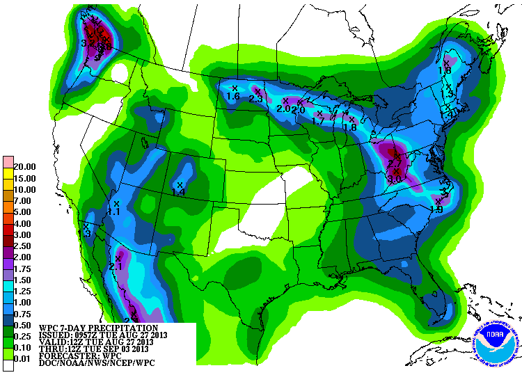
As the 7 day QPF map on the right shows, our chances of picking up anything more than a heavy dew are pretty much in the slim to none category through that time frame. That is not to say there is absolutely no chance of rain; just that the chances of any one location receiving measurable rainfall are too small to put on the forecast maps. The data continues to suggest that a very few, very isolated showers/storms could develop with the daytime heating over the course of the weekend or early next week. The most likely location would be in the more terrain favored areas of extreme E OK or NW ARK, but even there the chances are quite small.
Also, since we will keep a rather light southerly wind, that also means we will stay hot and humid through that time frame as well. So far, we have managed to avoid the extreme heat with daytime highs generally running only a degree or two above normal. That will be changing over the next few days as there are some indications that our surface winds will have a more SW component. That is always a warmer wind for us and should help push our daytime highs into the mid-upper 90s going into the weekend.
Some of the model guidance even suggests we may see some triple digits, but am not going to bite on that just yet. Thinking the green vegetation and still relatively moist soils are not being modeled accurately and that should help hold us below the triple digit mark. May be a moot point though as the combination of heat and humidity will certainly make it feel like 100+ over the next 5 or 6 days.
The upper level ridge of drier, warmer air that is centered over the state will be meandering around some over the course of the coming week. However, its influence will still be strong enough for just some daytime cloud cover and keeping a lid on most if not all of any showers/storms that try to form.
Eventually, this system will break down and there are some indications that a weak surface boundary may try to move this way early next week. However, it will likely be well after that time frame before a more significant cool front makes it this far south. So, the month of August will end on a hot, humid note and the month of September will start off on a hot, humid note. At least we are not enduring the extremes of the last couple of summers.
In the meantime, stay tuned and check back for updates.
Dick Faurot
More Like This
August 27th, 2013
April 15th, 2024
April 12th, 2024
March 14th, 2024
Top Headlines
April 26th, 2024
April 26th, 2024
April 25th, 2024


