Hot Thursday, Rain From Isaac Friday.
Mild night tonight, heating up again on Thursday before we have a chance at rain from Isaac on Friday.Wednesday, August 29th 2012, 3:11 pm


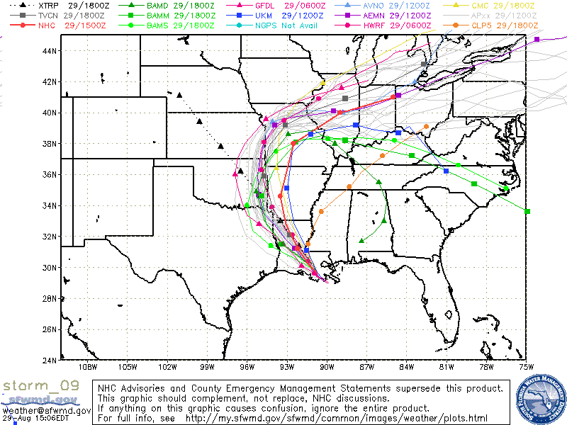
All eyes continue to be on Isaac as it churns along the Gulf coast and eventually turns northward. The spaghetti plot on the right shows a better consensus from the various computer models than has been the case over the last several days. Notice most of the projected tracks are now clustering along the OK/ARK state line. There are a few outliers which is often the case, but the better clustering does lead to greater confidence in the ultimate track of the remnants of Isaac.
Keep in mind that the heaviest rains typically occur near and to the east of the position of the low pressure system and that the rains generally taper off very quickly to the west of the low. The result will be a very tight E-W rainfall gradient with locations along and east of the center potentially receiving 1-4" and locations to the west seeing much lesser amounts. That also means any east/west changes in the movement of the low will see a corresponding shift in where the rains fall and the rainfall amounts. Notice the QPF map which is the second map on the right which clearly shows that sharp E-W rainfall gradient. As mentioned, that gradient could shift further to the east or further to the west depending on the exact track of the system.
Look for clouds to be moving in by late Thursday or Thursday night in advance of the system and some lingering rain and clouds into the day Saturday. Friday should see the bulk of the rainfall.
The sunny skies of today will again produce low-mid 90s for daytime highs and we should be in the low-mid 90s again on Thursday. Cloudy skies and a gusty E to NE wind should hold daytime temperatures into the lower 80s for Friday with some areas possibly staying in the 70s throughout the day. Once the remnants move out, ridging aloft will build back over the state resulting in lots of sunshine by Sunday and well into next week. That means daytime temperatures will be well into the 90s, depending on the extent and magnitude of the left over rainfall footprint.
Barring any surprises, this all adds up to a very warm Labor Day weekend. There may be some lingering showers first thing Saturday morning, but Sunday and Monday look to be mostly sunny and dry along with daytime temperatures in the 90s and morning lows in the lower 70s. In other words, very summer like.
So, stay tuned and check back for updates.
Dick Faurot

Get The Daily Update!
Be among the first to get breaking news, weather, and general news updates from News on 6 delivered right to your inbox!
More Like This
August 29th, 2012

April 15th, 2024

April 12th, 2024

March 14th, 2024
Top Headlines

April 25th, 2024

April 25th, 2024


April 25th, 2024
