

Storms, Severe Weather Risks Friday For Green Country
A lead short wave is generating some scattered showers and thunder this morning ahead of our main storm system that arrives this afternoon with additional thunderstorm chances.Friday, April 24th 2020, 3:25 am
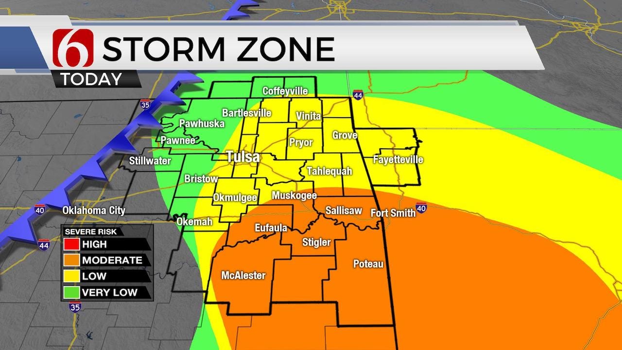

A lead short wave is generating some scattered showers and thunder this morning ahead of our main storm system that arrives this afternoon with additional thunderstorm chances. The activity this morning should remain sub-severe but could produce some small hail and gusty winds from 30 t0 45 mph in stronger cores.

Some storms later this afternoon will have the ability to produce severe weather, including hail and damaging winds and even a tornado or two. The tornado threat remains low across the metro but will be increasing slightly across east central to southeastern OK. The storm threats will end from the northwest to southeast later tonight with pleasant weather for the weekend. Our next system arrives Tuesday with a surface cold front and upper level system providing chances for strong and severe storms. Highs today will reach the mid-70s before the associated surface low and cold front pass the area this afternoon and evening. Temperatures this weekend will be pleasant with Saturday morning lows in the upper 40s to 50 followed by afternoon highs near 70. Sundays highs should reach the mid-70s with a return of south winds and warmer weather continuing into early next week. Daytime highs will be nearing the lower 80s Tuesday before the front “back-doors” across the state with a minor reduction in temperatures Wednesday.

South winds have returned overnight in advance of the upper level system located across the central Rockies this morning. A surface low developed last night and is now located across northwestern OK this morning and should move across central to eastern OK by the afternoon while dragging a pacific cold front across the state. Before these features arrives, south winds will attempt a fast fuel-up of moisture directly ahead of the developing system. This plume of moisture will be positioned along and east of highway 75 by midday as the upper level disturbance reaches central Kansas and stronger winds move across the state. This upper forcing combined with the surface front moving southeast will aid in scattered thunderstorm development between 2pm and 4pm today along and east of I-35 in central Kansas with storms moving east or even developing along the boundary as it approaches the highway 75 corridor early afternoon. Storms will quickly develop and move across east-central and far southeastern OK by early evening capable of producing some severe weather. The initial timing supports the threat of severe weather ending by early evening. The main threats continue to be very large hail, winds near 65 mph and pockets of heavy rainfall. The tornado threat has increased some compared to our data from yesterday, mostly across extreme eastern and southeastern OK into western Arkansas. This morning’s activity should remain mostly sub-severe.
Thanks for reading the Friday morning weather discussion and blog.
Have a super great weekend.
Alan Crone

Get The Daily Update!
Be among the first to get breaking news, weather, and general news updates from News on 6 delivered right to your inbox!
More Like This

April 24th, 2020

November 30th, 2022

November 1st, 2022

August 26th, 2022
Top Headlines

December 12th, 2024

December 12th, 2024

December 12th, 2024

December 12th, 2024