Wet, Chilly Wednesday East With Snow Across NW Oklahoma
A wet and chilly midday to afternoon is straight ahead for Eastern OK with heavy snow developing later today across far northwestern OK.Wednesday, December 2nd 2020, 6:16 am
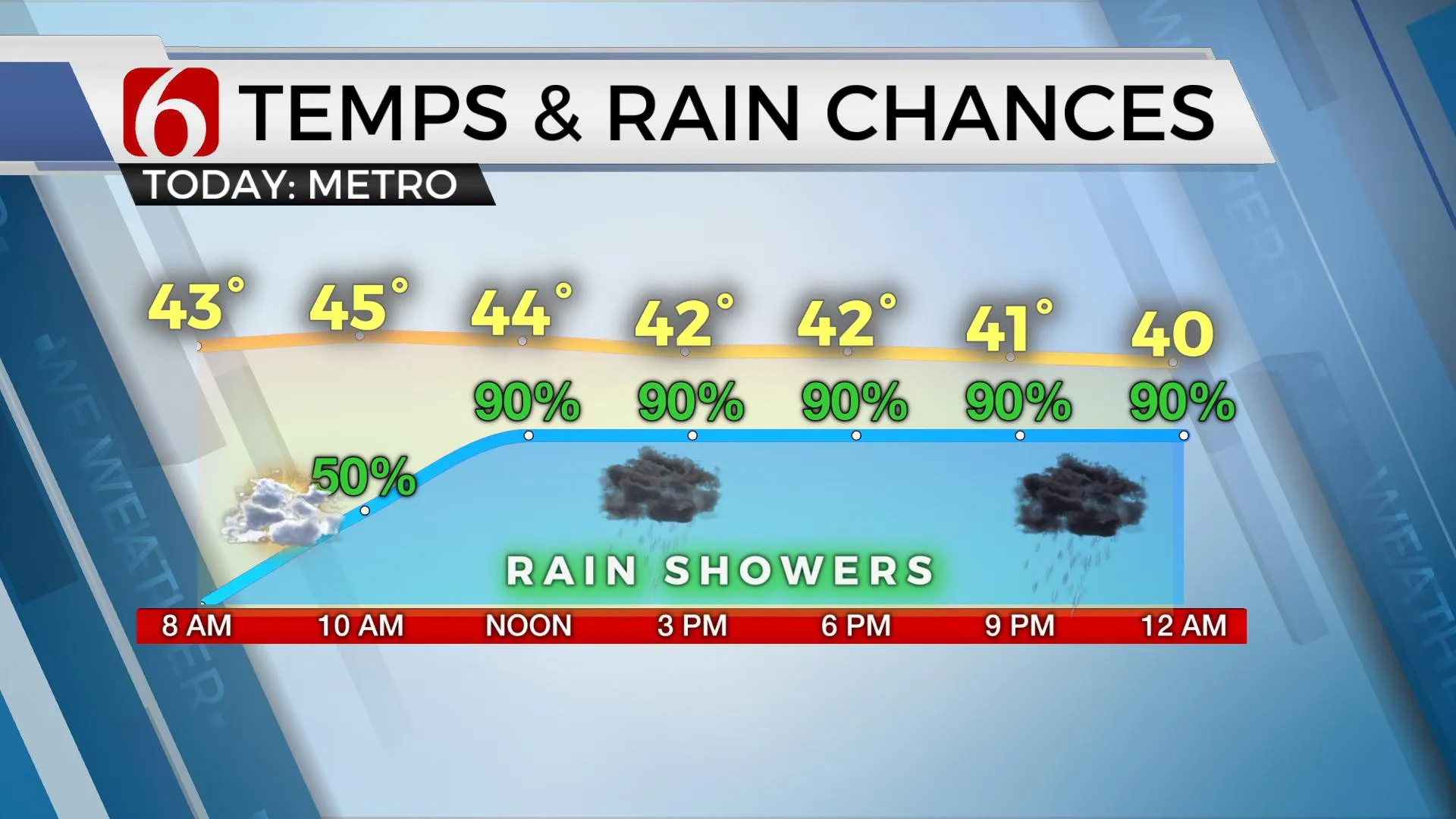
A wet and chilly midday to afternoon is straight ahead for Eastern OK with heavy snow developing later today across far northwestern OK. Late tonight into early Thursday morning, some locations north and northwest of the metro may experience a transition from rain to light snow with minor accumulations across part of southeastern Kansas, Washington, Osage and Pawnee counties. Most of the Tulsa metro should continue to see mostly light rain Thursday morning with a slight chance of mixing with some flurries or snowflakes. We do not anticipate any accumulation in the immediate Tulsa metro. If the storm system moves more south and east than anticipated, our forecast could change. Temperatures today will remain in the mid-40s through midday before falling tonight into the mid-30s. Thursday afternoon highs will only reach the upper 30s north and lower 40s across far southeastern OK. We will expand the probabilities for light rain showers with occasional snowflakes into at least midday Thursday as the main upper-level system pivots across far Eastern OK. This system will exit late Thursday night into early Friday allowing more sunshine and pleasant weather Friday afternoon into the weekend. Friday morning lows will start in the 20s and end with highs in the upper 40s and lower 50s. The weekend features lows in the upper 20s and lower 30s along with highs reaching the lower to mid-50s with mostly sunny and pleasant weather. A weak front moves across the area Sunday evening or early Monday morning with a minor cool-down Monday with highs near 50. Warmer weather is expected for the middle of next week with highs reaching the lower 60s.

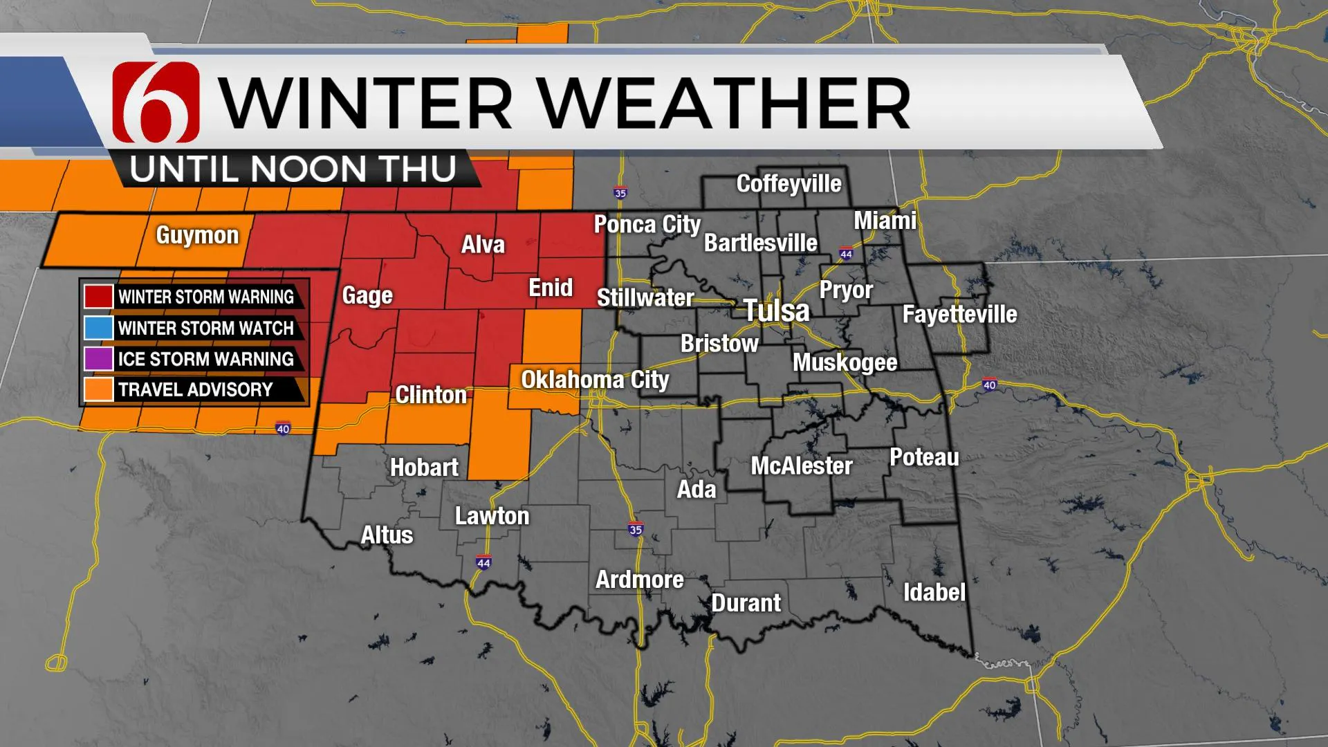
The positioning of the main upper level closed low will bring colder air aloft across central and northwestern OK later this afternoon and evening. A surface low-pressure area is expected to develop along the Red River in southwestern OK and transit eastward later tonight into Thursday morning. Locations near and northwest of the upper low will be in a favorable position for heavy snowfall from 6 to 12 inches across far northwestern OK and southwestern Kansas. These areas are now included in winter storm warnings. Other locations across west-central to central OK may receive 1 to 4 inches of snow. A winter weather advisory is posted for these locations. At this point, no counties in our immediate area of concern are included in winter storm warnings, watches or advisories.

As with most winter storms in Oklahoma, a change in trajectory by even 50 to 75 miles with the closed low or changes in the surface low track could bring significant changes to the forecast. Please check back often for any updates.
Thanks for reading the Wednesday morning weather discussion and blog.
Have a super great day!
Alan Crone
KOTV
Check out my ‘Weather Out The Door’ mini-podcast. Search for ‘NewsOn6’ on most providers, including Apple, Stitcher, Tune-In, SoundCloud and here on Spotify.
More Like This
December 2nd, 2020
February 14th, 2022
January 26th, 2022
January 25th, 2022
Top Headlines
December 11th, 2024
December 11th, 2024
December 11th, 2024
December 11th, 2024


