Cold Morning Temperatures, Clearing Skies
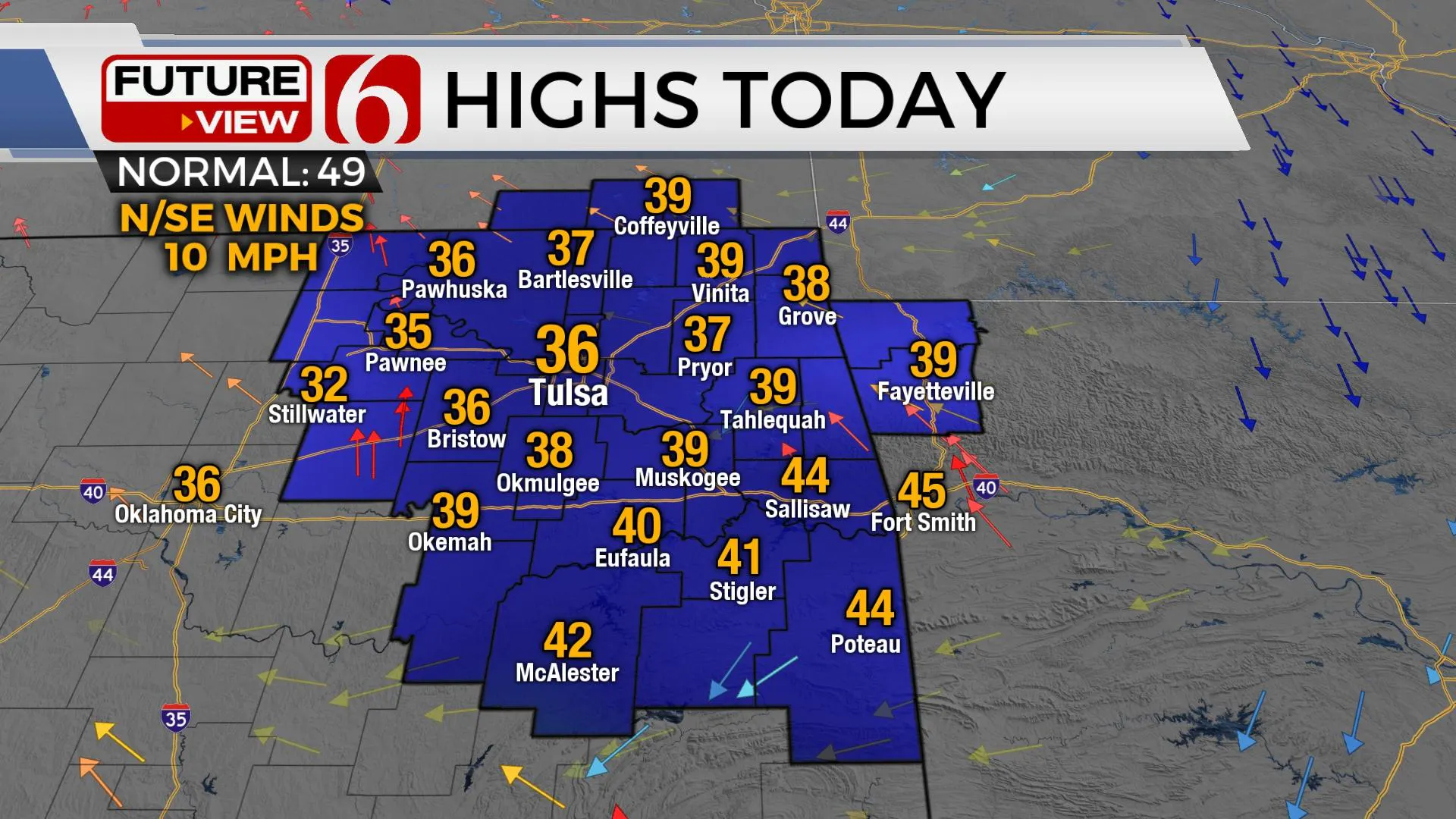
Clearing sky and light winds have promoted very cold temps this morning over the snowpack regions of eastern OK. Secondary roadways should be considered slick and hazardous, especially untreated elevated surfaces, bridges, and overpasses, but mainline highways should be in good shape. Highs will be in the mid to upper 30s today before our next system quickly approaches Tuesday with snow chances. The Tuesday system is not as strong as yesterday’s storm, but will produce some light snow for EasterMonday, December 14th 2020, 6:14 am
Clearing skies and light winds have promoted very cold temps this morning over the snowpack regions of eastern OK. Secondary roadways should be considered slick and hazardous, especially untreated elevated surfaces, bridges, and overpasses, but mainline highways should be in good shape. Highs will be in the mid to upper 30s today before our next system quickly approaches Tuesday with snow chances. The Tuesday system is not as strong as yesterday’s storm, but will produce some light snow for Eastern OK.

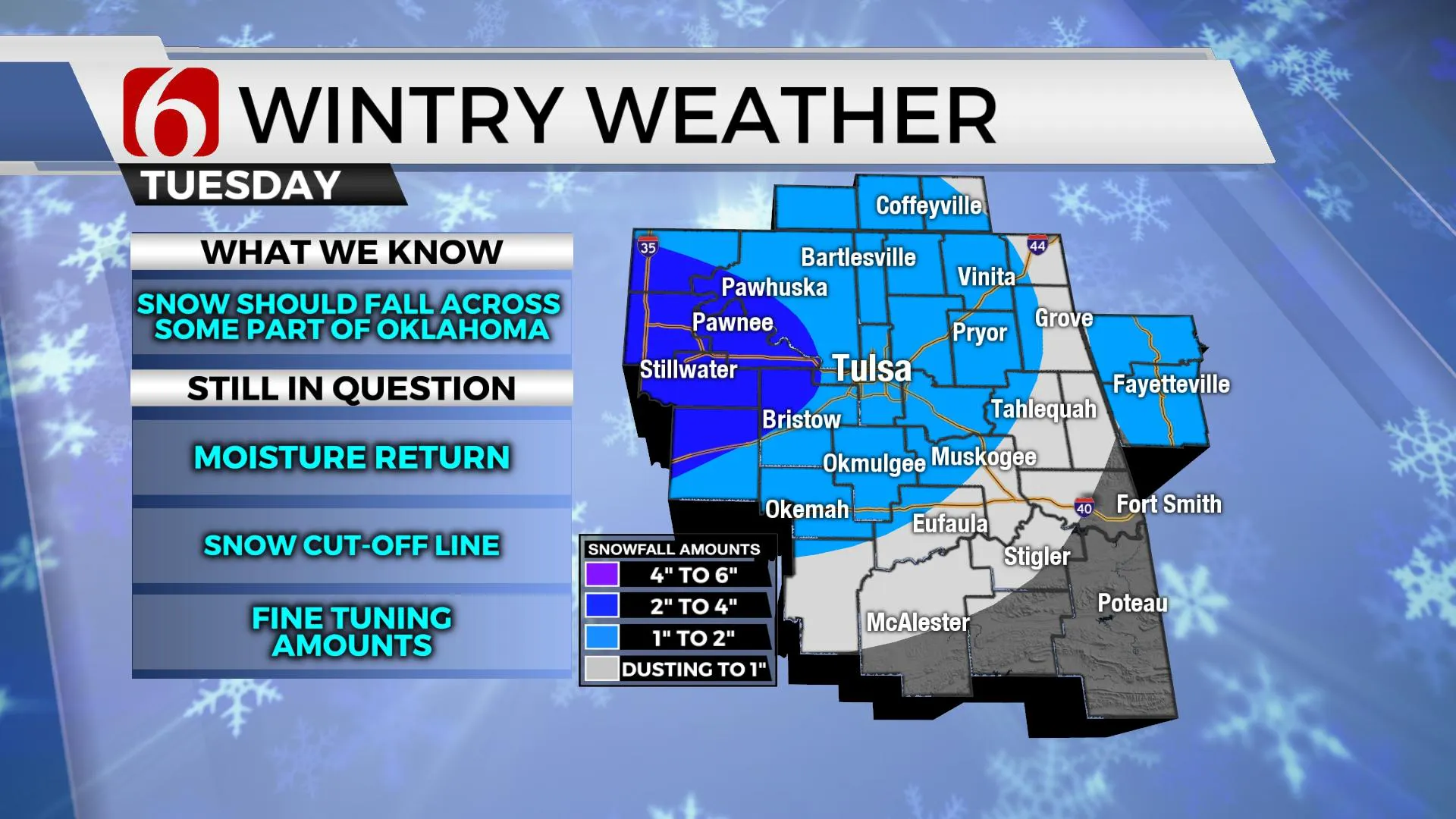
The next upper-level trough scheduled for the area will arrive Tuesday bringing another chance for wintry precipitation across part of the state. The Tuesday system is not quite as robust as the previous snow maker and may be positioned slightly north compared to the Sunday track. The surface low may track slightly more south compared to Sundays system. But this system should produce another swath of measurable and accumulating snow across part of northern OK. Locations along the highway 412 corridor will be in the running for 1 to 2 inches with some locally higher totals near 3 inches west of the metro. Locations south of I-40 will once again be on the far southern sections of the system and may experience more rain versus snow, but even some light wintry weather will be possible in these areas with little impact. A winter weather advisory is likely to be issued for part of northeastern OK for this system near and west of the Tulsa metro.

Temps Tuesday should reach the mid to upper 30s for the afternoon before the snow begins allowing readings to drop into the lower 30s. Snow will develop Tuesday morning across northwestern OK but the timeline for the metro is mostly Tuesday afternoon and exiting late Tuesday night. Another weak storm system approaches the state Friday evening, but thermal profiles support all liquid with temperatures remaining to warm for wintry weather. This system should have only low impacts and mostly across extreme eastern OK late Friday into early Saturday. The weekend looks good.
Thanks for reading the Monday morning weather discussion and blog.
Have a super great and safe day.
Alan Crone
KOTV
More Like This
December 14th, 2020
February 14th, 2022
January 26th, 2022
January 25th, 2022
Top Headlines
December 13th, 2024
December 13th, 2024
December 13th, 2024
December 13th, 2024


