

Brief Warm Up On Monday Before Cold Front Moves In
A brief warm-up is underway for the next two days before a cold front slices across the region on Wednesday with a slight chance for a few showers followed by the return of seasonal weather into the weekend. The pattern suggests colder weather may follow next week.Monday, November 15th 2021, 6:03 am

TULSA, Oklahoma -
A brief warm-up is underway for the next two days before a cold front slices across the region on Wednesday with a slight chance for a few showers followed by the return of seasonal weather into the weekend. The pattern suggests colder weather may follow next week.
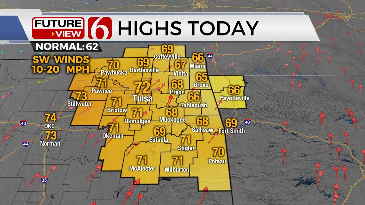
Northwest upper air flow currently underway slowly transitions to a near zonal flow as a powerful upper-level trough parallels the U.S.-Canadian border Tuesday through Wednesday as the base of this feature brushes the southern plains Wednesday. A pair of surface lows will deepen during this early week period, one located in southern Canada with snow, and the other ejecting from the Rockies into the central plains. Winds across the southern plains will return from the south today around 10 to 20 mph and increase speeds Tuesday in response to pressure falls along the Rockies and Plains. Temps will also be warm. Highs today will reach the lower 70s, and Tuesday reach the upper 70s to near 80.
As the surface front moves across the area Wednesday morning to midday, a few showers or some areas of drizzle will be possible, but low-level moisture is not expected to support any robust areas of rain or storms. Wednesday highs will be reached during the morning to midday into the mid or upper 60s before the cold front brings falling temps and gusty north winds midday to afternoon. The NAM characteristically is much colder with the drop, placing northeastern OK into the 40s by late Wednesday afternoon. This is possible and I’m leaning toward the lower end of guidance for the afternoon and evening. A surface ridge builds into the area Thursday and part of Friday before quickly exiting. This means Thursday morning starts in the lower to mid-30s with afternoon highs reaching the mid-50s with sunshine and north winds. Friday supports lows in the lower 30s with highs in the mid to upper 50s with a return of south winds Friday through the weekend as another system nears the state with a Sunday frontal passage. Moisture will remain limited with only a small mention for precipitation with the Sunday front.
The pattern suggests that a chunk of shallow, arctic air will break loose and invade part of the northern U.S. next week. Stay tuned.
Thanks for reading the Monday morning weather discussion and blog.
Have a super great day!
Alan Crone

Get The Daily Update!
Be among the first to get breaking news, weather, and general news updates from News on 6 delivered right to your inbox!
More Like This

November 15th, 2021

August 8th, 2023

July 4th, 2023

May 8th, 2023
Top Headlines

December 12th, 2024

December 12th, 2024

December 12th, 2024

December 12th, 2024