

Strong Cold Front Brings Big Changes Soon
Showers chances return to Green Country on Thursday. News On 6 Meteorologist Alan Crone has the latest in his daily weather blog.Thursday, November 10th 2022, 7:48 am
If you’re into podcasts or in a rush, check out my daily weather update. Search for NewsOn6 and ‘Weather Out The Door’ on most podcast providers, including Spotify, Stitcher and Tune-In, or Click Here to listen on Apple Podcasts.
TULSA, Okla. - Showers chances return to Green Country on Thursday.
Here are the details from News On 6 Meteorologist Alan Crone:

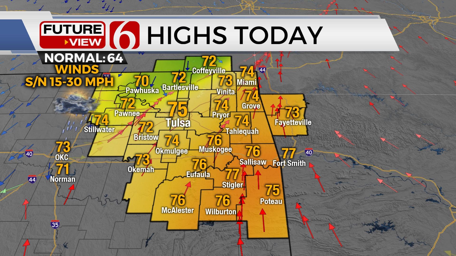
Gusty south winds and warm weather will remain Thursday morning before storms arrive in the afternoon, unleashing the return of colder weather. This pattern change will stick around for the foreseeable future. Another strong upper-level system is likely to impact the area early next week, including the possibilities of some wintry weather impacts.

The cold front is expected to arrive by Thursday afternoon and exit the area by the evening. A chance for scattered showers and storms will exist along the boundary, but additional showers and storms are also expected behind the front as the system sweeps southeast across the state. Stronger upper-level dynamics will be positioned slightly north but we may still have a few strong storms along the OK-KS state line region with small hail and gusty winds possible, but these types of storms are not likely.

Temperatures will remain mild on Thursday morning, mostly in the upper 60s, with southeast winds from 15 to 30 mph. Daytime highs will reach the mid-70s north and possibly upper 70s south before the strong front brings colder weather into the area this afternoon and evening. We anticipate a stout temperature drop as the front moves across your area later today and this evening. In the Tulsa metro, temps will drop from the mid-70s to the lower 50s or even upper 40s by the 5pm to 6pm hour with strong northwest winds developing behind the front. This cooler, colder weather will migrate southeast as the evening progresses. Most of the precip will be east of the area by midnight with clearing sky and chilly conditions Friday. A Canadian ridge of high pressure will build southward setting the stage for a cold weekend. Highs tomorrow will stay in the mid to upper 40s with sunshine and north winds from 15 to 30 mph. A few data runs hint at some flurries or snow showers that could develop Friday evening as the main upper level trough finally clears the region. This is only depicted in a few runs. I’ll insert a very low mention for this scenario late Friday across northeastern OK. As the trough exits and any clouds also scoot out, a hard freeze is likely Saturday morning with most locations dropping into the lower and mid-20s. After highs will remain in the 40s Saturday but rebound into the lower 50s Sunday.

Our next strong upper-level system arrives Monday night into Tuesday from the west-southwest and brings threats for some wintry precipitation across the state. It's too early to speculate exact specifics, but the pattern supports a mention for some rain changing to snow. Colder air will already be in place and colder air aloft is likely to impact the area with this system. This pattern can easily bring some wintry weather if the trajectory of the upper trough moves nearby. We may also track another similar wave for the latter half of next week. We'll have more on the different scenarios tomorrow.
Thanks for reading the Thursday morning weather discussion and blog.
Have a super great day!
Alan Crone
KOTV

Get The Daily Update!
Be among the first to get breaking news, weather, and general news updates from News on 6 delivered right to your inbox!
More Like This
November 10th, 2022

June 21st, 2023

June 19th, 2023

June 13th, 2023
Top Headlines

December 15th, 2024

December 15th, 2024

December 15th, 2024

December 15th, 2024