

Gusty Winds Return To Green Country
Expect gusty winds across Green Country on Tuesday before storms chances return on Wednesday.Tuesday, February 21st 2023, 6:03 am
If you’re into podcasts or in a rush, check out my daily weather update. Search for NewsOn6 and ‘Weather Out The Door’ on most podcast providers, including Spotify, Stitcher and Tune-In, or Click Here to listen on Apple Podcasts.
TULSA, Okla. - Expect gusty winds across Green Country on Tuesday before storms chances return on Wednesday.
Here are the details from News On 6 Meteorologist Alan Crone:
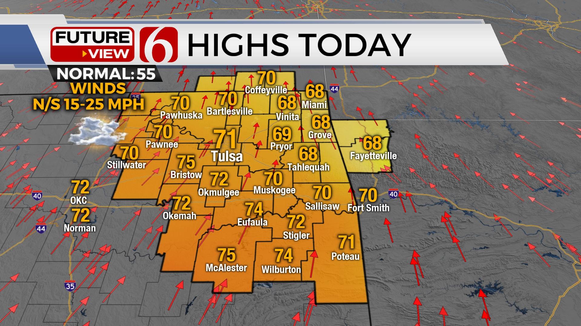
Gusty south winds return on Tuesday afternoon with highs in the lower 70s north and mid-70s south. Showers and storms arrive overnight into early Wednesday morning. Some could be strong to severe. Colder and blustery conditions are likely Thursday and Friday.

A cut-off low positioned across the Baja is beginning to move east and should arrive quickly later Tuesday night and exit our area Wednesday as a powerful storm system drops from the Pacific northwest across the western U.S. This system brings a major winter system across the Rockies and into the central plains to the Midwest as another shallow arctic boundary also moves across the northern half of the nation. The winter portion of this system, from the Rockies into the Midwest, will bring major snow, powerful winds, and extremely cold temperatures and blustery wind chill values. This shallow arctic front enters northern OK late Wednesday evening or early Thursday morning but the coldest air with this system will remain north of the state. We'll see a noticeable cool-down Thursday and Friday before the shallow air mixes and modifies as the next upper-level system approaches from the west this weekend.

We'll be mostly dry for most of Tuesday, but showers and storms will begin developing and moving into the region later Tuesday night into early Wednesday morning. A few hours before the main forcing arrives from the west, low level moisture will rapidly return from Texas into central and eastern Oklahoma with dew point temps reaching the upper 50s, possibly near 60. A surface low pressure area is likely to quickly develop across southeastern Colorado and lift northeast into central Kansas while a dry-line feature sharpens across western OK. Powerful mid to upper-level winds nearing 100 mph will race across the state early Wednesday morning with thunderstorms developing ahead of the dry line and the surface low. The strong winds aloft and increasing moisture will support the possibility of a few strong to severe storms despite the early arrival time resulting in limited surface instability. The main threat will be damaging winds, but a brief tornado cannot be ruled out.

As the dry line passes eastward Wednesday midday, the threat for showers and storms will end as dry and windy weather arrives from the west. The fire danger spread rates will still be problematic for a small window early Wednesday afternoon near and west of I-35 with greater fire danger across the high plains of Texas. As the surface low ejects north, the shallow arctic air mass will drop south bringing north winds and colder weather late Wednesday night into early Thursday morning. This boundary may become stationary along the Jack Fork Mountains in southeastern OK before either dissipating or lifting north as a quasi-warm front Friday into Saturday morning. A few showers will be possible this weekend with a lead wave approaching from the southwest, but higher chances for additional thunderstorms will return Saturday evening into Sunday morning, and again Sunday night into Monday. I’ll have more about the weekend probabilities on Wednesday.

Thanks for reading the Tuesday morning weather discussion and blog.
Have a super great day!
Alan Crone
KOTV

Get The Daily Update!
Be among the first to get breaking news, weather, and general news updates from News on 6 delivered right to your inbox!
More Like This
February 21st, 2023

June 21st, 2023

June 19th, 2023

June 13th, 2023
Top Headlines

December 15th, 2024

December 14th, 2024

December 14th, 2024

December 14th, 2024