

Chance For Severe Storms Return Thursday Night
The threat for severe weather returns on Thursday.Thursday, June 15th 2023, 2:49 pm


TULSA, Okla. -
TULSA, Okla. - The threat of severe weather returns on Thursday.
Here are the details from News On 6 Meteorologist Alan Crone:
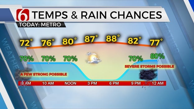
Unseasonably strong upper air flow will bring another storm complex near the area late Thursday night. Strong to severe thunderstorms will be likely near and southwest of the Tulsa Metro.
Primary threats for the Eastern third of the state include large hail and damaging winds. Storm threats to our west do include mentions for all modes, including very large hail and tornadoes and damaging winds. Initial thunderstorm development is expected near the Oklahoma and Texas Panhandle regions between 4 and 6 p.m. on Thursday afternoon.
Discrete supercells will be capable of producing extremely large hail, damaging winds, and tornadoes. A few additional supercells may develop across West central Oklahoma through the early evening.
Storms eventually should congeal into a large complex of activity while moving east and southeast through the evening hours. Most of the threats with this convective complex of storms will be damaging winds from 60 to near 80 mph along with large hail and extremely heavy rainfall. A moderate risk of severe weather is currently posted for portions of northwestern to near central Oklahoma and includes the Oklahoma City metro region. Surrounding the moderate risk, an enhanced area of severe weather threats extends from near Stillwater to McAlester southward into the North Texas region. The slight risk region includes locations from Ponca City to Tulsa to Muskogee.
If you’re into podcasts or in a rush, check out my daily weather update. Search for NewsOn6 and ‘Weather Out The Door’ on most podcast providers, including Spotify, Stitcher and Tune-In, or Click Here to listen on Apple Podcasts.
As this lobe of energy passes the area early Friday morning, a few additional storms will be possible across the Eastern third of the state. Additional storms are likely to develop Friday night across Southeastern Colorado and Southwestern Kansas with the current trajectory keeping these storms to our north Saturday morning. Another strong disturbance arrives across the state Saturday evening sparking additional thunderstorms. Individual supercell storms may develop early in the evening before a complex of storms will become likely late Saturday night moving from portions of Southern Kansas into Northern Oklahoma. This will bring yet another threat of large hail, damaging winds, and heavy rainfall to part of the area. We anticipate most of the showers and storms will be east of our area after early Sunday morning, but a few additional showers or storms may occur Sunday afternoon. A mid-level ridge of high pressure is anticipated to expand from Texas northward early next week bringing increasing heat and humidity to the state. There will continue to be a favorable upper airflow by the second half of next week that could bring a small complex of storms nearby.
Temperatures will start into the mid and upper 60s this morning before climbing into the upper 80s and lower 90s this afternoon. Southeast winds will return this afternoon at 10 to near 15 mph. Temperature trends tomorrow morning will start in the 60s with Friday afternoon highs into the upper 80s. Saturday high temperatures should reach the upper 80s and lower 90s with Sunday afternoon high temperatures in the lower 90s. Early next week mid 90s are likely with heat index values near 100.
Thanks for reading the Thursday morning weather discussion and blog.
Have a super great day!
Alan Crone

Get The Daily Update!
Be among the first to get breaking news, weather, and general news updates from News on 6 delivered right to your inbox!
More Like This

June 15th, 2023

July 12th, 2023
July 7th, 2023

June 26th, 2023
Top Headlines

December 14th, 2024

December 14th, 2024

December 14th, 2024

December 14th, 2024