

A Few Storm Chances Before Triple Digits Return
A Medical Heat Alert is in effect on Monday morning as summer temperatures continue across Green Country.Monday, June 26th 2023, 5:57 am


If you’re into podcasts or in a rush, check out my daily weather update. Search for NewsOn6 and ‘Weather Out The Door’ on most podcast providers, including Spotify, Stitcher and Tune-In, or Click Here to listen on Apple Podcasts.
TULSA, Okla. - A Medical Heat Alert is in effect on Monday morning as summer temperatures continue across Green Country.
Here are the details from News On 6 Meteorologist Alan Crone:
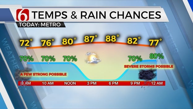
A few showers and storms will quickly fade-away across far southeastern Oklahoma early Monday morning near a weak surface boundary that moved across the area Sunday afternoon. This boundary will provide some minor relief from humidity across most of the area on Monday, but heat advisories will remain for extreme southeastern OK where dewpoint temps in the mid to upper 70s will remain. Afternoon highs in the northeastern quadrant of the state will range from the upper 80s across extreme northern sections to lower 90s near Tulsa. Locations along I-40 south will remain in the mid-90s.
The next few days will see a mid-level ridge centered across Texas expanding northward. This ridge has been responsible for a heat wave across Texas for the past three weeks. The northern periphery of the ridge will stay near the northern half of the state for the next two days. This means we'll still be in the running for a small complex of storms nearing the area later tonight into early Tuesday with another short-wave moving across at least southern Kansas Tuesday night into Wednesday. The weak boundary that moved across the area yesterday effectively attempts to return northward later tonight as a quasi-warm front. A few showers and storms will be possible in the zone near the metro overnight into early Tuesday morning. Until the ridge nudges slightly more north, the window remains for another small complex of storms to brush far northern OK and southern Kansas late Tuesday night into pre-dawn Wednesday. After Wednesday morning, the ridge should expand and shut down the storm chances for a few days.
Heat and humidity will remain the main story for the middle to end of the week as the ridge center will be across the Red River Valley before flattening and sliding southeast this weekend.
Highs will reach the mid-90s Tuesday, and near 100 to 103 Wednesday and Thursday. The green vegetation across the region may keep afternoon highs slightly below potential, but I’ll keep these readings into the triple digits from Wednesday through Friday. Heat index values will support another heat advisory with indices in the 105 to 108 range. As the ridge flattens and slides southeast late Friday into Saturday, this will allow another surface front nearing the state with additional shower and storm chances for some locations that will last into the early to middle part of next week. This will also bring temps down near normal highs this weekend into early next week.
Thanks for reading the Monday morning weather discussion and blog.
Have a super great day!
Alan Crone
KOTV

Get The Daily Update!
Be among the first to get breaking news, weather, and general news updates from News on 6 delivered right to your inbox!
More Like This

June 26th, 2023

July 12th, 2023
July 7th, 2023

June 15th, 2023
Top Headlines

December 12th, 2024

December 12th, 2024

December 12th, 2024
