Friday cold front brings gusty winds, weekend showers possible
A strong cold front will arrive in Oklahoma on Friday, bringing gusty winds, fire danger concerns, and a chance for rain and thunderstorms Saturday, with cooler temperatures before a warming trend returns next week.Thursday, March 6th 2025, 6:31 pm
TULSA, Okla. -
As the surface ridge moves east and the next storm system develops to the west, the pressure gradient will increase. This will result in southeast winds increasing to 15 to 25 mph later today. The gusty winds will continue this evening, overnight and into Friday.
Despite recent rainfall, fire spread rates will be moderate this afternoon near and west of the Tulsa metro area.
When Does the Next Cold Front Arrive?
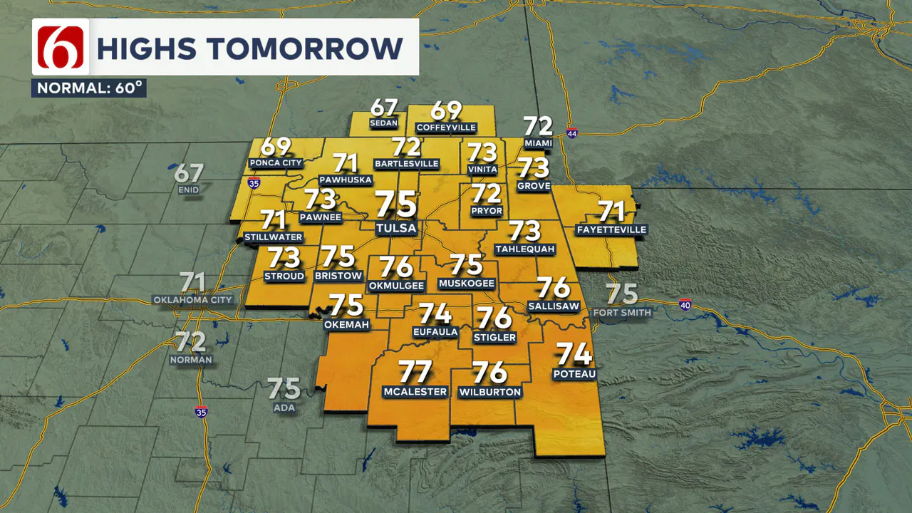
The next front arrives Friday. But a warming trend will continue before the front arrives, with Friday morning lows in the upper 40s and lower 50s and Friday highs in the upper 60s and lower 70s.
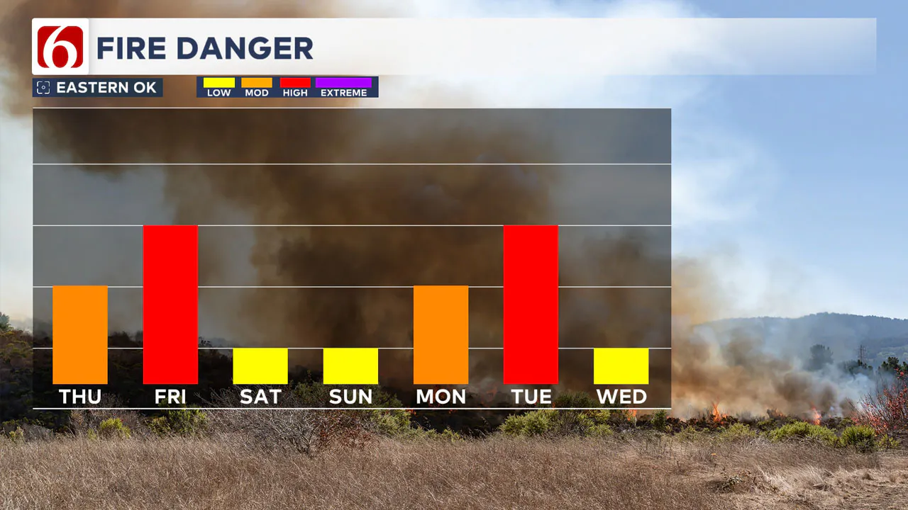
The fire danger issues will ramp up Friday due to the strong southwest winds and dry fuels across the area. A cold front will move across northern Oklahoma late Friday afternoon, bringing cooler weather on Saturday.
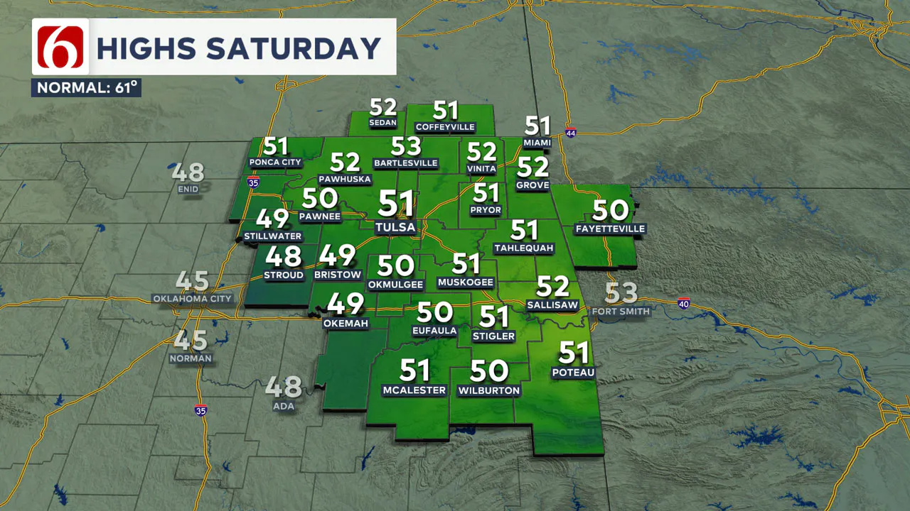
High temperatures on Saturday will remain in the lower 50s as another storm system approaches the Southern Plains.
Any Rain This Weekend?
Yes, there will be some rain, but the chances are higher south compared to the north. Most of us will have at least a chance for showers.
A strong upper-level storm system will move out of the desert southwest and across parts of Oklahoma Saturday. While the exact trajectory of this system may change slightly, it is expected to bring precipitation chances near and south of the Tulsa metro area by Saturday.
Colder air aloft associated with this dynamic system could result in some snow across southwestern Oklahoma and western North Texas. Instability will be limited, but some thunder is possible on Saturday near and south of the I-40 corridor.
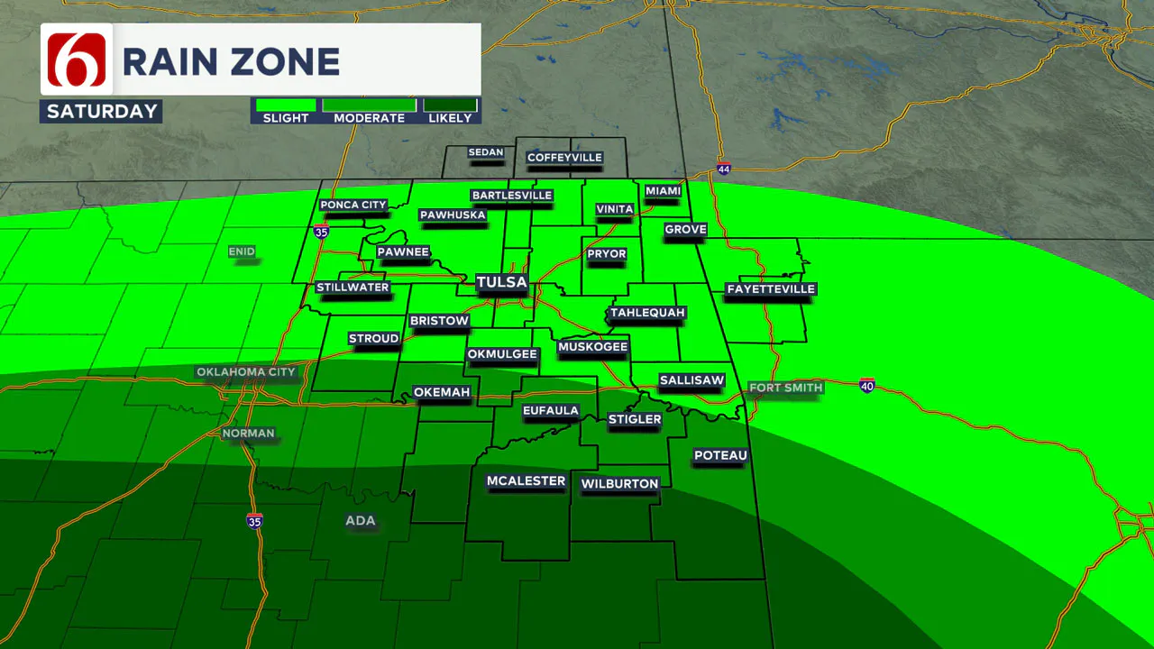
Severe weather is not expected in Oklahoma.
The probability of precipitation for the Tulsa metro area is 20 to 30%, with much higher chances south of the I-40 corridor.
What About Sunday?
Sunday will be much improved compared to Saturday. As this upper-level system exits the area Saturday night, temperatures will rebound on Sunday. Morning lows will be in the mid-30s, with daytime highs reaching the mid-60s under sunny skies.
A robust warming trend is likely for several days next week before another strong storm system moves across the central and southern Plains by Wednesday.
Early Next Week Forecast
On Monday, morning lows will be in the upper 30s and lower 40s, with daytime highs reaching the mid-70s.
Tuesday will start with morning temperatures near 50 and daytime highs in the mid to upper 70s.
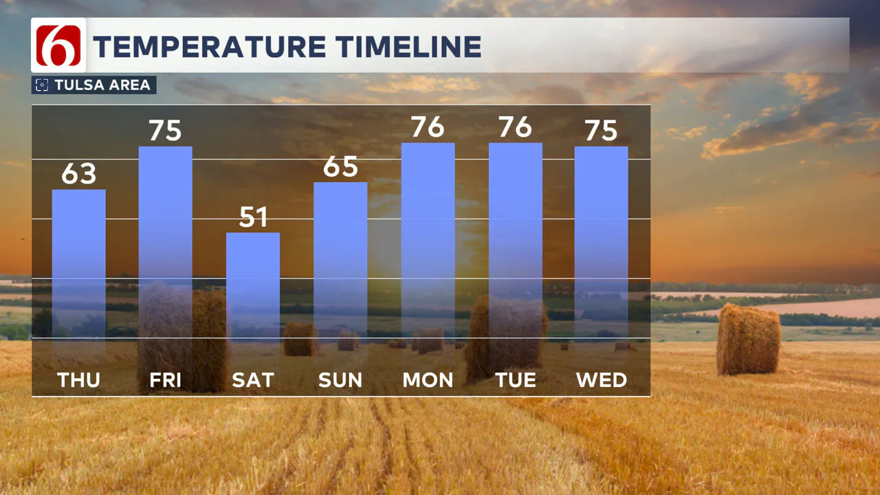
By Wednesday, strong south winds will bring morning lows in the 50s and highs in the mid-70s as another strong upper-level system moves across the area. Moisture will be limited but is expected to support a chance for a few showers or storms, mostly across the eastern third of the state into Western Arkansas.
A second system is likely to impact the region by Friday, with thunderstorm chances returning if low-level moisture increases. The probability of storms currently remains low.
Fire Danger Awareness
As mentioned in the blog yesterday, varying levels of fire danger threats will persist over the next several days. Some days may present higher spread rates than others, so please remain aware and avoid outdoor burning when stronger winds are present.
Tuesday Storm Damage
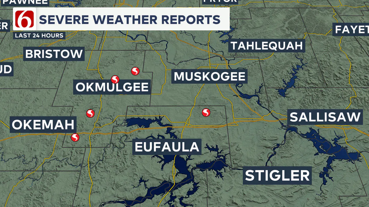
Severe storms that swept across eastern Oklahoma early Tuesday morning spawned at least five confirmed tornadoes in Okmulgee and McIntosh counties, resulting in damage to homes, trees, and power lines. The National Weather Service continues to survey affected areas, and additional tornadoes could still be identified.
👉 Read the full breakdown of Tuesday’s tornadoes and storm damage.
———
Emergency Info: Outages Across Oklahoma:
Northeast Oklahoma has various power companies and electric cooperatives, many of which have overlapping areas of coverage. Below is a link to various outage maps.
- PSO Outage Map
- OG&E Outage Map
- VVEC Outage Map
- Indian Electric Cooperative (IEC) Outage Map
- Oklahoma Association of Electric Cooperatives Outage Map — (Note Several Smaller Co-ops Included)
The Alan Crone morning weather podcast link from Spotify:
https://open.spotify.com/episode/50lJ3VaWzv1WweDUMqht7j
The Alan Crone morning weather podcast link from Apple:
Follow the News On 6 Meteorologists on Facebook!
- Meteorologist Travis Meyer
- Meteorologist Stacia Knight
- Meteorologist Alan Crone
- Meteorologist Stephen Nehrenz
- Meteorologist Aaron Reeves

More Like This
March 6th, 2025
March 6th, 2025
March 6th, 2025
Top Headlines
March 6th, 2025
March 6th, 2025
March 6th, 2025


