Rain Continues For Thursday Morning; Cold Front Arrives
The moderate rainfall continues to push southward early this morning as the cold front also continues to move southward across the state.Thursday, November 7th 2019, 6:07 am
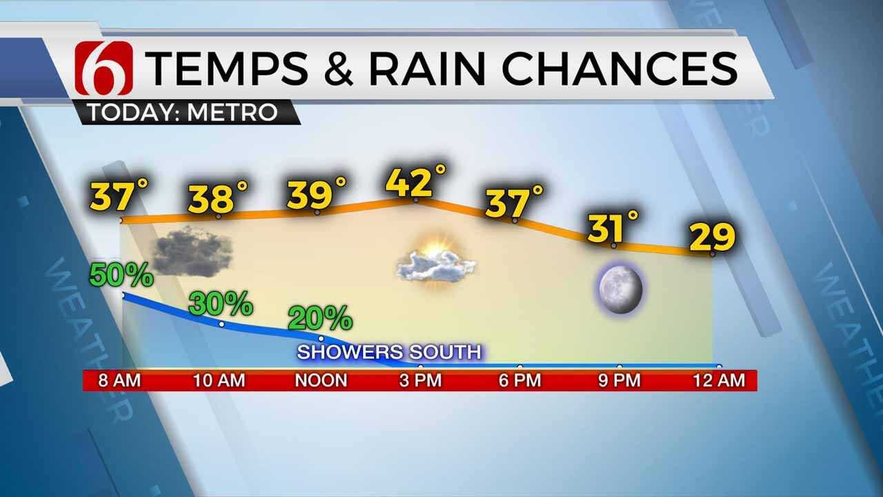
The moderate rainfall continues to push southward early this morning as the cold front also continues to move southward across the state. Blustery north winds from 20 to 30 mph will remain for several hours today bringing highs in the lower 40s north this afternoon and mid-40s south. Some wind chill values may drop into the upper teens or lower 20s briefly this morning with wind chills in the lower 30s later this afternoon.

Rain showers will continue for a while this morning across northern OK before ending but may linger through early afternoon across southern OK. Clouds will be slowly thinning by early afternoon from the north to south. A surface ridge of high pressure builds into the area Friday with sunny yet cold weather before moderating temperatures arrive Saturday into the mid-60s for afternoon highs.
Pleasant weather will remain for almost all of Sunday before a very strong, shallow arctic airmass plows across the nation influencing part of northeastern OK Sunday night into early next week with the coldest air to date for the fall season.

The data continue to waffle with the timing of the Sunday PM or Monday morning arctic air mass. Typically, these types of fronts will arrive faster and generally not slower than model data depictions, but with variance spread between several models, its hard to peg a specific frontal passage at this point. More than likely this boundary will arrive Sunday evening. The data is also trending toward slightly more precipitation chances with this system.
There will be a small window for a few showers across southern OK Sunday night and a chance for a few areas of freezing rain or snow across far northern OK Monday morning through midday. Both probabilities will remain very low for this update due to the inconsistencies in the data. Precip types with shallow airmasses tend to favor freezing or mix, but the actual magnitude of the front is such that precip types would more than likely be snow for southeastern Kansas, northeastern OK and northwestern Arkansas. Again, at this point, chances are low but may be increasing in subsequent updates.
The bitterly cold air should stick around for several days next week.
Thanks for reading the Thursday morning weather discussion and blog.
Have a super great day!
Alan Crone

Get The Daily Update!
Be among the first to get breaking news, weather, and general news updates from News on 6 delivered right to your inbox!
More Like This
November 7th, 2019

April 15th, 2024

April 12th, 2024

March 14th, 2024
Top Headlines

April 26th, 2024


April 26th, 2024
April 26th, 2024
