

Back To Fall Weather Wednesday Across Eastern Oklahoma
<p>Its back to fall weather for the next few days after a strong front has moved across northeastern Oklahoma yesterday evening and early this morning. </p>Wednesday, September 26th 2018, 3:57 am


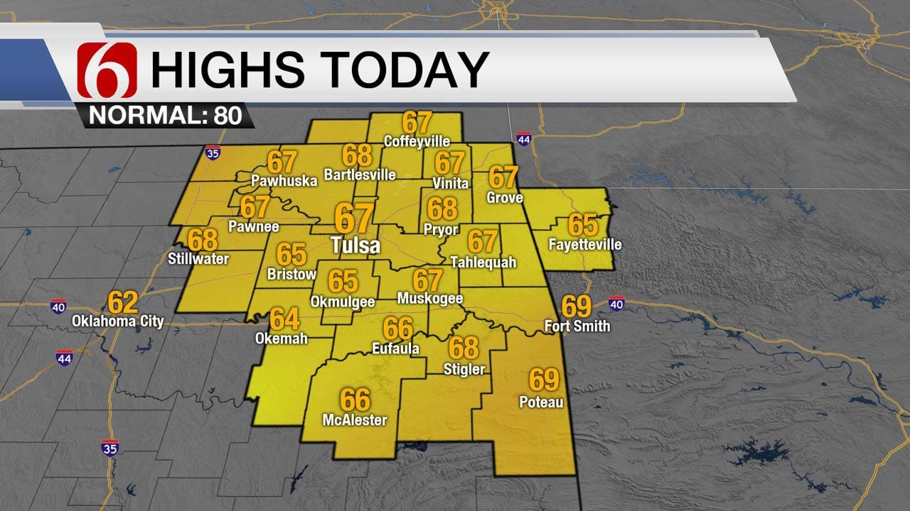
Its back to fall weather for the next few days after a strong front has moved across northeastern Oklahoma yesterday evening and early this morning. This boundary is currently located across the Red River Valley region with northeast winds and cooler temperatures overspreading our area. The main upper level trough is located across the Midwest, but the tail end of the long wave feature will not clear the state until sometime later tonight or even early Thursday morning. This means we'll keep a chance for showers near the area today with most of the activity spreading across the southern sections by afternoon and evening. Temperatures today will start in the 50s and stay only in the mid to upper 60s for afternoon highs with mostly cloudy sky. A few sun breaks or some clearing sky will be possible late today and early evening across southern Kansas and northern Oklahoma. This will allow temps to drop into the 40s across far northern Oklahoma and the mid-50s across southeastern sections. The Tulsa metro is expected to be near 50 Thursday morning and will be the first chilly morning for most locations this early fall.
The pattern will slowly bring warmer weather back into the state with Thursday afternoon temps in the mid-70s along with sunshine and dry air.
The upper air pattern will bring another disturbance across the northern plains Friday into Saturday helping to move a cold front southward near the state by late Friday night or Saturday morning. The data continue to be highly inconsistent with this feature. It may pass the metro late Friday night or could remain slightly northward before lifting into the central plains states this weekend. We continue to make some minor adjustments to the forecast regarding Saturdays temps (trending lower and not higher) with a slight chance for a few showers or storms.
Early next week this boundary is expected to remain across central Kansas with breezy, humid and warm weather returning to the state. Our highs are expected in the mid-80s before our next system arrives by the middle to end of next week with thunderstorm chances and another cool-down.
Thanks for reading the Wednesday morning weather discussion and blog.

Get The Daily Update!
Be among the first to get breaking news, weather, and general news updates from News on 6 delivered right to your inbox!
More Like This
September 26th, 2018

September 29th, 2024

September 17th, 2024

Top Headlines

December 14th, 2024

December 14th, 2024

December 14th, 2024

December 14th, 2024