A Warm October Soon to Turn More Inclement
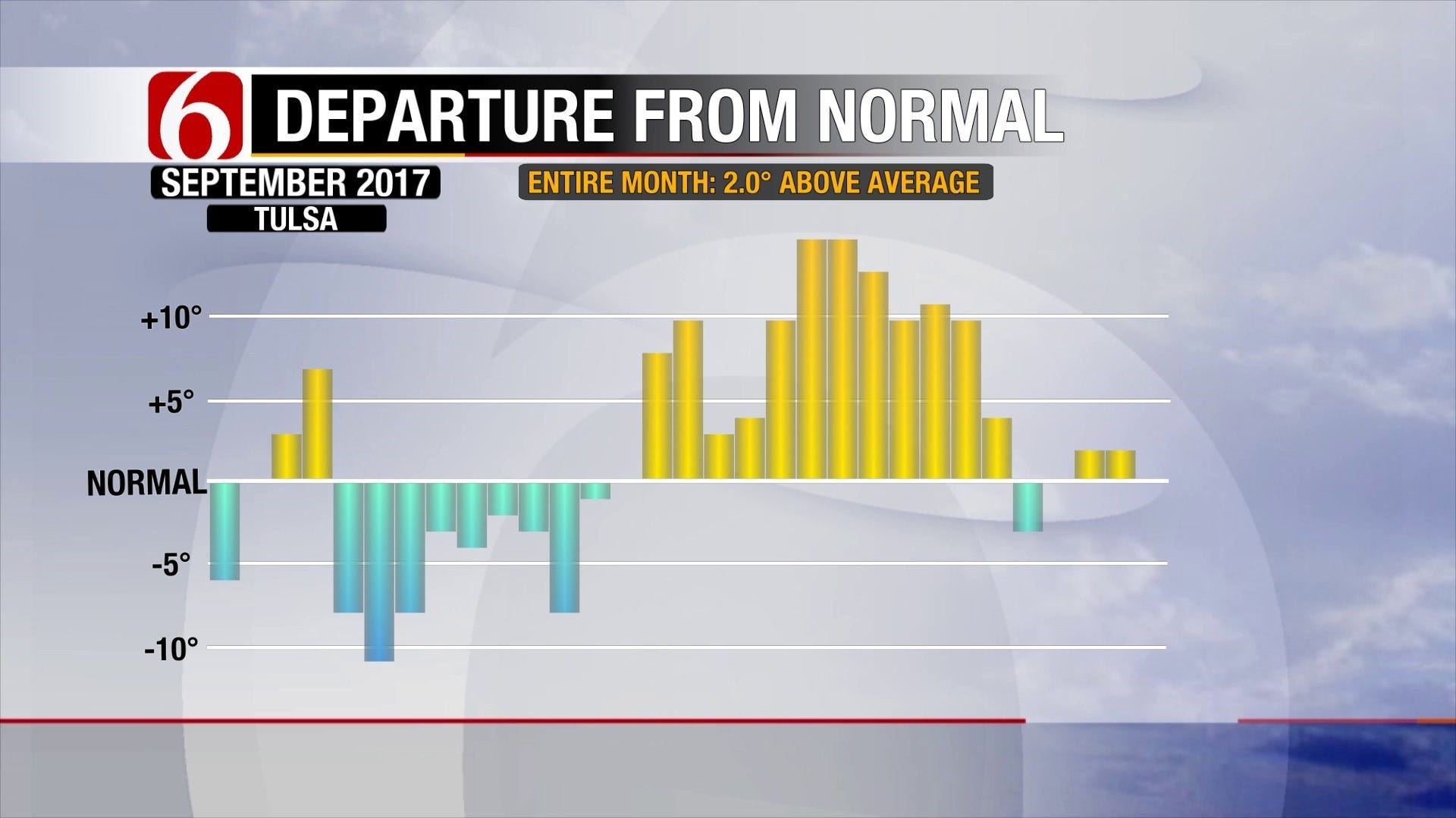
A transition in the months has yet to lead to a transition in the weather conditions for Oklahoma. September ended as October begins with warmer than normal weather. The graph below shows what seemed to be a fast transition to fall early in the month leading to a revival of summer temperatures in the latter half of September. Another big change in that trend awaits us in about a week. In the meantime, we’ve got a warm, dare I say muggy, week ahead with rain and storm chances. [...Sunday, October 1st 2017, 11:13 pm
A transition in the months has yet to lead to a transition in the weather conditions for Oklahoma. September ended as October begins with warmer than normal weather. The graph below shows what seemed to be a fast transition to fall early in the month leading to a revival of summer temperatures in the latter half of September. Another big change in that trend awaits us in about a week. In the meantime, we’ve got a warm, dare I say muggy, week ahead with rain and storm chances.
[img]
The warmth comes thanks to an unseasonably strong high pressure ridge in the jet stream. While not centered overhead, we’ll feel the effects of a summer-like pattern , fire danger and all by Monday. Gusty south winds develop as temperatures soar well into the 80s. The recent dry spell, especially southeast of Tulsa, paired with these conditions leads to that threat during the day. By Tuesday, the daytime warmth is tempered by returning moisture and cloud cover. Tuesday will be our transition to a more unsettled pattern as several waves of energy ride around the ridge, scraping by Oklahoma.
[img]
Showers may begin as early as Tuesday, but more widespread rain and storms are possible Wednesday as a frontal boundary sinks into the area and stalls out for a bit. While this won’t come with any surge of cooler air, our temperatures may not make it out of the 70s midweek with clouds and occasional rain. Wednesday appears to be the wettest day in the week ahead, but rain chances persist well beyond then. The trough out west reloads and sends another strong wave our way this weekend, bringing another round or two of rain and storms to Green Country. I don’t think we’ll see any day beyond Wednesday as a washout, but there could still be more weather interruptions to outdoor events at the Tulsa State Fair. In other words, the fair weather won’t be so “fair” later this week… so enjoy the midway while it’s guaranteed to be nice!
[img]
I am closely watching the weather this weekend, not only given the prevalence of outdoor activities, but because I am getting married on Saturday! Fortunately, I had the sense to have an indoor wedding. A meteorologist would never live down a water-logged wedding of his or her own! Whatever your weekend plans are, count on at least one nice day given the progressive pattern at that point. It’s not likely any rain-makers stick around very long.
The real-deal chill of fall arrives next week. Another big pivot in the jet stream sends southward a powerful cold front that likely keeps temperatures from rising above the 60s several days in the second week of the month. For those longing for the crisp, cool fall air, you will just have to wait a bit longer. The Outlook into mid-October shows we are bulls-eye for cooler-than-normal air. Fall will be rushing back into Green Country, but not before a little spring and a little summer show up again first.
[img]
For more weather updates be sure to follow me on Twitter: @GroganontheGO and on my Facebook Page!
More Like This
October 1st, 2017
September 29th, 2024
September 17th, 2024
Top Headlines
December 13th, 2024
December 13th, 2024
December 13th, 2024
December 13th, 2024


