

Incredibly Mild Start to August
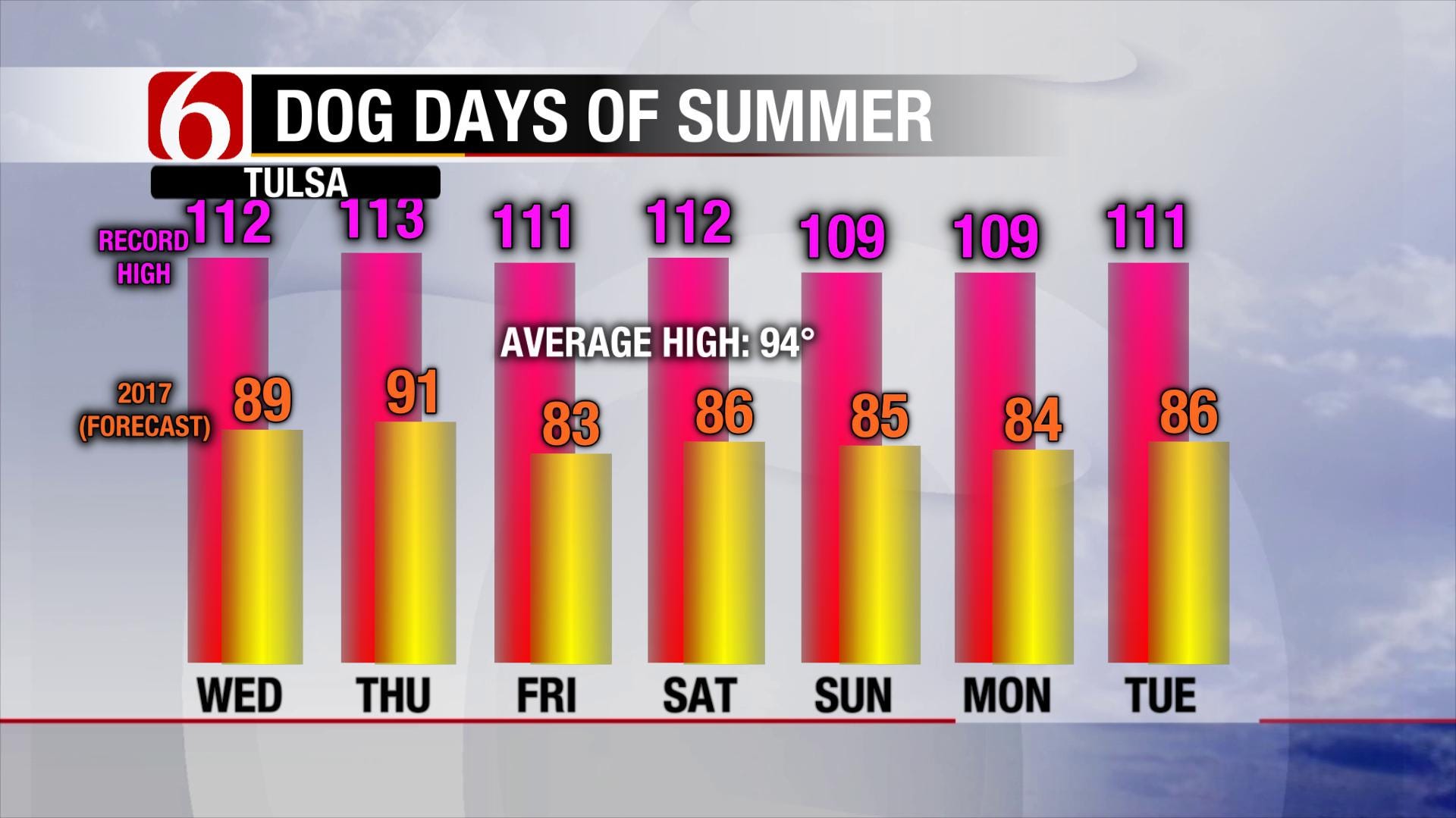
It feels more like the first day of October than the first day of August. Temperatures have hovered in the 70s all day for most of the area with overcast skies, mist and light rain. As of 6pm, Tulsa had tied its record coolest high for the date. The first week in August is usually the hottest in the year for Tulsa. That certainly won’t be the case for 2017 as shown below. This refreshing air is especially welcome after a hotter and drier than average July. But will it last? [im...Tuesday, August 1st 2017, 7:29 pm


It feels more like the first day of October than the first day of August. Temperatures have hovered in the 70s all day for most of the area with overcast skies, mist and light rain. As of 6pm, Tulsa had tied its record coolest high for the date. The first week in August is usually the hottest in the year for Tulsa. That certainly won’t be the case for 2017 as shown below. This refreshing air is especially welcome after a hotter and drier than average July. But will it last?
[img]
The reason for the cool-down is the heat ridge’s retreat to the West. This allowed a cold front to pass through late last week and several waves of energy riding down the jet stream our way continue to reinforce this cooler air, like today’s system. We do see a bump in those readings Wednesday and Thursday ahead of another cold front. Even then, our afternoon highs will barely creep above 90°. Keep in mind our average high this time of year is 94°. There is just not enough time for heat to build and overspread the area!
[img]
That next storm system arrives late Thursday, bringing another possible round of showers and possible thunderstorms. It shouldn’t be anything too dramatic, but the end result will be mild, rather dry air to for the end of the week. By Saturday morning, the air may be dry enough for morning lows in the 50s! Who knew you could give your air conditioning a break in Oklahoma this time of year?
It doesn’t look like the weather pattern brings back typical August heat anytime soon. Over the weekend, another wave of energy rides southeast in the jet stream, bringing more clouds, rain and possible storms as early as Saturday. We may see this type of unsettled weather into early next week with a couple rounds of heavy rainfall possible. We could end up with totals from 1” to more than 3” between now and midweek next week. That’ll really green up our surroundings again!
[img]
The outlook through mid-August in fact supports this continued trend. Much cooler and significantly wetter than normal weather may take us through our typical “Dog Days” rather unscorched. We’ll still have a few days reaching the 90s between now and mid-month, but triple-digit readings (or anything near it) appears very unlikely. That’s the kind of summer weather we can tolerate!
[img]
[img]
For more weather updates, be sure to follow me on Twitter: @GroganontheGO and like my Facebook Page.

Get The Daily Update!
Be among the first to get breaking news, weather, and general news updates from News on 6 delivered right to your inbox!
More Like This
August 1st, 2017

September 29th, 2024

September 17th, 2024

Top Headlines

December 14th, 2024

December 14th, 2024

December 14th, 2024

December 14th, 2024