

Windy, Windy Wednesday In NE Oklahoma Following Storms
<p>The first upper-level system is moving across the southern and central plains this morning and will quickly turn northeast by midday taking the showers and storms away from the immediate area. </p>Wednesday, May 17th 2017, 4:04 am


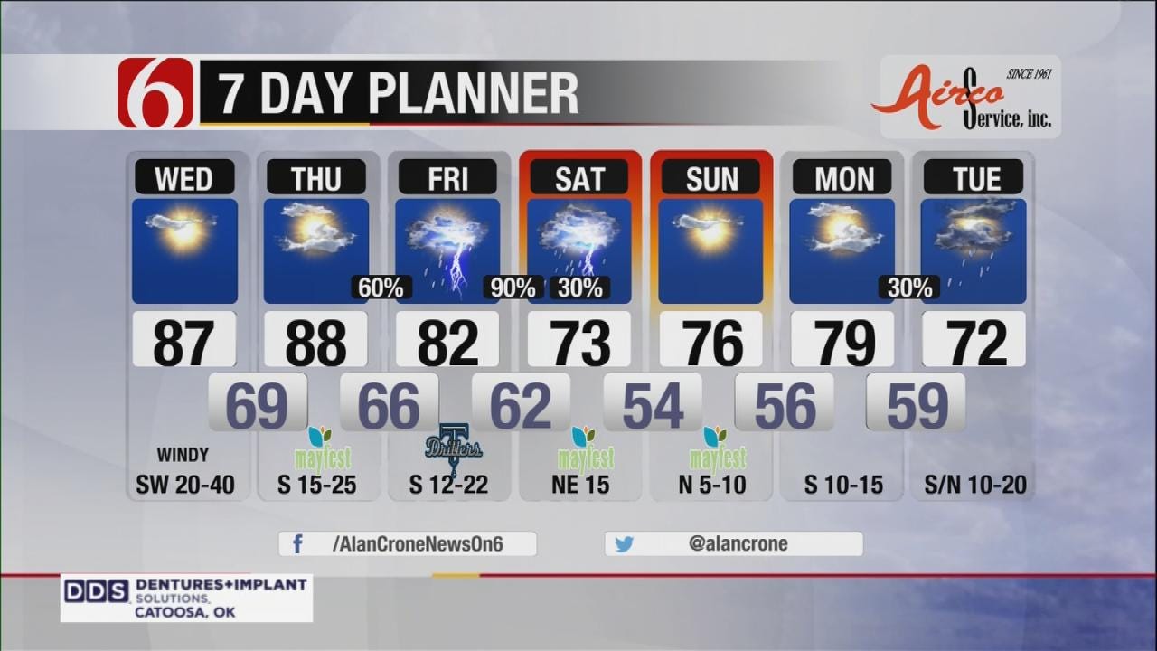
The first upper-level system is moving across the southern and central plains this morning and will quickly turn northeast by midday taking the showers and storms away from the immediate area.
As I post this morning, a line of thunderstorm activity (squall line) is moving eastward. As this line moves eastward it should weaken during the pre-dawn hours between 5 a.m. and 7 a.m. and exit eastern OK shortly thereafter. Strong southwest winds and highs in the mid to upper 80s will be likely. The morning clouds will quickly leave with the gusty winds and sunshine remaining for the area.
The next upper-level system will be nearing the state Thursday and not exit until sometime this weekend. The result will be several rounds of thunderstorm activity, beginning late Thursday night, and lasting through at least Saturday morning and possibly Sunday across southeastern OK.
Heavy rainfall and severe weather threats will remain Thursday late through Saturday morning. Rainfall amounts from 2 to 4 inches will be possible with this 2nd system and flood watches may be required for part of northeastern OK during latter half of the week into the weekend.
EURO and GFS data continue to have big differences in the outcome of the upper trough and more importantly when the trough will lose its influence on the state.But it appears the data is starting to converge on a solution and we have continued to keep Sunday only at a 10% pop and have placed more weight in the faster GFS data.
Basically, the system should be exiting sometime Saturday morning to midday with improving conditions Sunday. The next fast moving system will drop down into the state Monday night into Tuesday with a round of storms followed but a noticeable cool-down for a few days next week.
Thanks for reading the Wednesday morning weather discussion and blog.
Have a super great day!
Alan Crone
KOTV

Get The Daily Update!
Be among the first to get breaking news, weather, and general news updates from News on 6 delivered right to your inbox!
More Like This

May 17th, 2017

September 29th, 2024

September 17th, 2024

Top Headlines

December 11th, 2024

December 11th, 2024

December 11th, 2024

December 11th, 2024