A Warm Close to January, Unsettled Start to February
<p>This is what a meteorologist might call a “boring” weather pattern at the moment. There are no major storm systems in the country and temperatures aren’t straying too far from normal. But, keep reading! It’s about to get more interesting as we head into the new month. A surge of mild air will be replaced by wintertime chill this week, and the dry spell will likely be interrupted.</p>Sunday, January 29th 2017, 10:39 pm
This is what a meteorologist might call a “boring” weather pattern at the moment. There are no major storm systems in the country and temperatures aren’t straying too far from normal. But, keep reading! It’s about to get more interesting as we head into the new month. A surge of mild air will be replaced by wintertime chill this week, and the dry spell will likely be interrupted.
[img]
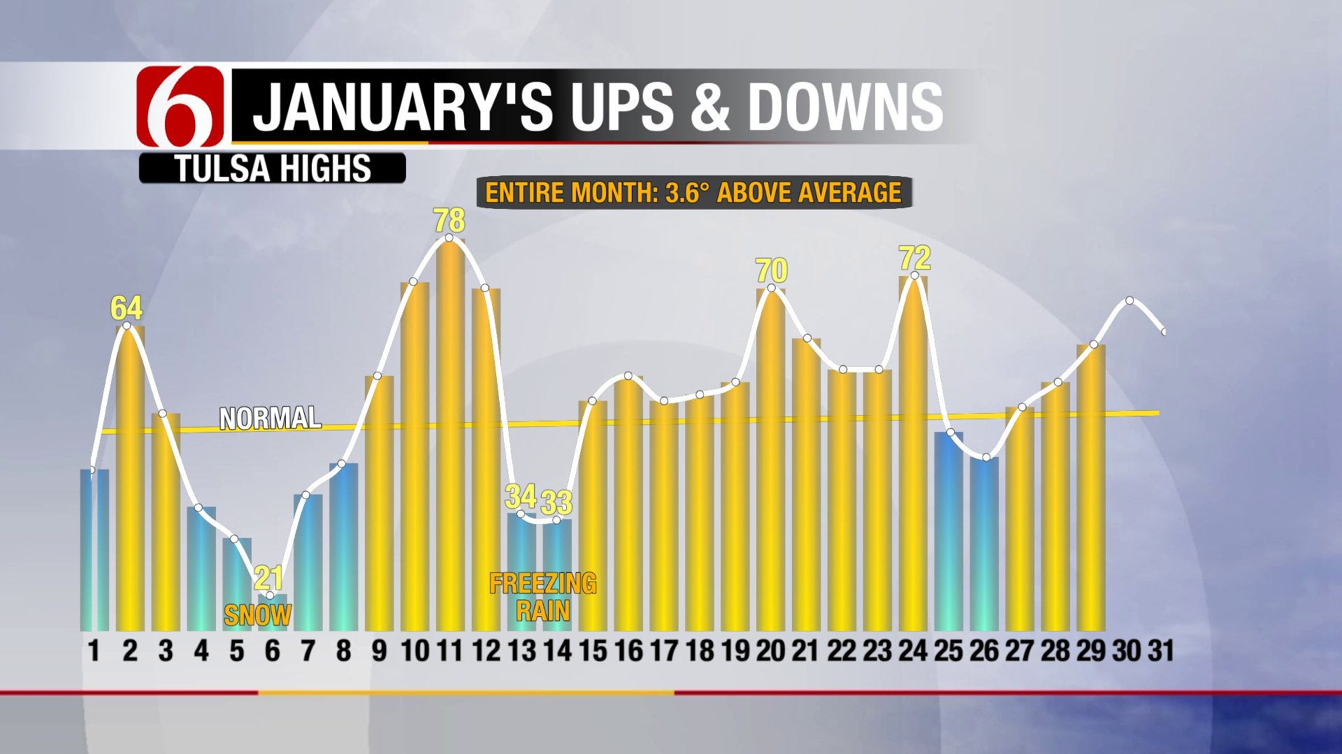
January has been quite the roller coaster ride. As the high temperature trend in Tulsa for the month shows above, we’ve been all over the place. Most recently, we’ve enjoyed a nice warming trend and it will continue on our Monday as temperatures peak near 70° by afternoon. Winds will be lighter than previous days, but the relatively humidity will be lower allowing for a continued fire danger. The dormant and increasingly dry vegetation will be prime fuel for any fires to spread with the highest risk for wildfires south and west of Tulsa. Aside from that concern, Monday will be an absolutely beautiful day as our streak of sunny weather continues.
[img]
A weak cold front arrives that night, starting a trend towards cooler days. Tuesday won’t be so bad. In fact, many areas may reach the 60s again for highs as the front stalls out in Green Country. However, cooler air will continue to spill southward midweek, though nothing too harsh, thanks to a jet stream with a rather gentle northwesterly slope.
As we roll into the new month, it gets more unsettled. We’ll see moisture start to overrun the colder air in eastern Oklahoma creating overcast skies and some showers Thursday and Friday. Regardless of what the groundhog sees on Thursday, it’ll feel like winter as head into the weekend. A stronger storm system will race eastward and provide more widespread rain. As of now, it looks like temperatures will stay mainly above freezing, precluding any major winter weather threat. However, we can’t rule out at least a brief period of light freezing rain in a few areas. The clouds and potential rain will keep those temperatures down into the 30s and 40s from Thursday into the weekend. Thus, it’ll be time for the heavier jackets and coats again.
The rain will be much-needed although not much is promised in our computer models. It might just be enough to settle the dust as the system moves rapidly through the area. While Tulsa has a surplus of rain compared to our year-to-date average, we have an overwhelming deficit when you factor in how dry 2016 was for much of the area. The most recent Drought Monitor below shows nearly all of our region is in some Drought Category at this point. It’s our driest time of the year so climatology is not on our side for seeing much improvement. Nor is the long-term outlook later into February. Beyond the weekend, we are likely back to another dry spell for another week. This will come with a return to mild temperatures overall as Arctic air is showing no signs of spilling southward into the Lower 48 through that time.
[img]
[img]
We still have lots of the winter to go and Tulsa’s measly 0.7” of snow for the season won’t likely stand as the grand total. After all, some of our biggest snowstorms tend to come in February and March as greater amounts of moisture start to return from the Gulf of Mexico. And if it did stand as the grand total, we’d be matched by 8 other winters with less than an inch of snow in recorded history. It can happen! In the meantime, snow will not be on our minds with spring-like warmth. Enjoy it while we have this respite from the cold. Be sure to follow me on Twitter: @GroganontheGO and on my Facebook Page for more weather updates!
More Like This
January 29th, 2017
September 29th, 2024
September 17th, 2024
Top Headlines
December 14th, 2024
December 14th, 2024
December 14th, 2024
December 14th, 2024


