Cold, Then Warmer, Then Really Cold
<p>Much colder than normal for the next few days with a brief warm-up on Friday before the really cold air arrives Saturday.</p>Tuesday, December 13th 2016, 7:26 pm
Here we are, almost half way through the month of December and it has been quite a change from what we experienced during the Oct/Nov time frame which was the second warmest period on record. So far, temperatures are running more than 2 degrees below normal and that will continue to drop in the days ahead as more cold air is coming our way.
In fact, colder air has been moving in during the day today as the maximum temperature actually occurred shortly after midnight when a 42 was recorded. The normal value for this time of year is 49 and we will stay well below that over the next several days.
For the overnight hours, mostly cloudy skies will be the general rule and those northerly winds will diminish somewhat, but morning lows in the low-mid 20s and a wind of 5-10 mph will still put the wind chill down into the teens for many locations. Northerly winds of 10-20 mph during the day along with only a few breaks in the clouds will keep afternoon temperatures in the mid-upper 30s and wind chill values in the 20s. There might even be some drizzle or a few sprinkles during the course of the day, but anything that might fall will be extremely light and temperatures will be above freezing by then.
Thursday will also be mostly cloudy with morning lows in the 20s and daytime highs in the 30s along with an E/NE wind around 10 mph. Those winds will become more SE that night which should keep temperatures from dropping much to start the day on Friday.
Then there is Friday into Saturday which will be very different. A stronger cold front will be moving through the state during the early morning hours of Saturday but strong southerly winds ahead of the boundary should result in warming temperatures up until frontal passage. That means we will start Friday morning in the 30s, will have cloudy skies and gusty S/SE winds all day warming us into the 40s or low 50s by late in the day; and then holding in the 50s to near 60 until the cold front arrives early Saturday morning.
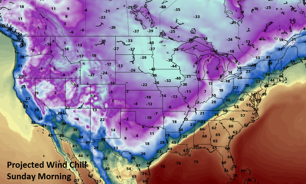
Once that front arrives there will be a rapid drop in temperatures which will continue to fall all day Saturday along with strong northerly winds making it feel even colder. Look for temperatures to be below freezing that afternoon and into the low teens or perhaps even single digits to start the day Sunday. Not only that, but brisk northerly winds will bring wind chill values into negative territory for Sunday morning. That is brutal.
[img]
As you can see on our forecast page, there will also be at least a chance of some light rain or showers on Friday as the warmer air surges northward. But, for Saturday there will be a chance of wintry precipitation as much colder air plunges back over the state and any precipitation should be ending by early Sunday morning. Amounts will be very light according to the 7 day QPF, but even a tenth of an inch of liquid equivalent correlates to about an inch of snow so we may have some snow cover to start the day Sunday. At any rate, temperatures will stay below the freezing mark all day Sunday and may not get above freezing on Monday either.
[img]
In fact, temperatures will remain below normal well into next week as you can see on the 6-10 day outlook which keeps us in the much cooler than normal category up to a few days before Christmas. Still not much of a precipitation signal though.
[img]
However, the 8-14 day outlook does suggest at least some moderation in temperatures. That time frame is also starting to show a wetter signal which does not necessarily mean the potential for a White Christmas. Lots of things can change between now and then.
[img]
[img]
So, stay tuned and check back for updates.
Dick Faurot
More Like This
December 13th, 2016
September 29th, 2024
September 17th, 2024
Top Headlines
December 15th, 2024
December 15th, 2024
December 15th, 2024
December 15th, 2024


