Very Windy Day Across Eastern Oklahoma
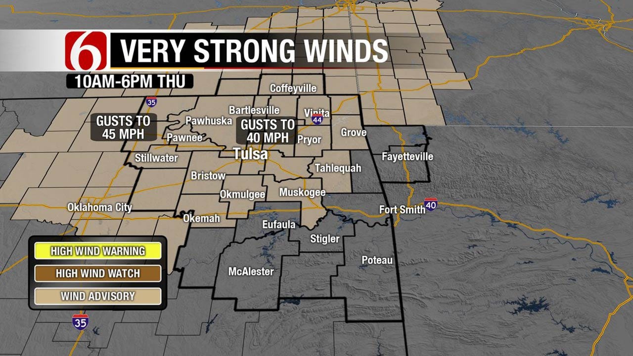
<p>After a record breaking day yesterday across the state with highs in the mid-80s, we’re looking at another very warm and very windy afternoon with highs again into the upper 70s or lower 80s before a strong cold front sweeps across the area tonight bringing colder air back to the state for a few days. </p>Thursday, November 17th 2016, 4:00 am
After a record breaking day yesterday across the state with highs in the mid-80s, we’re looking at another very warm and very windy afternoon with highs again into the upper 70s or lower 80s before a strong cold front sweeps across the area tonight bringing colder air back to the state for a few days.
A few showers or storms may occur along the boundary overnight but the odds will remain very low. Freezing temperatures are possible for the morning periods this weekend. Another system may near the area by Tuesday of next week but should exit the state before the Thanksgiving Holiday arrives.
A powerful upper level trough is lifting across the intermountain region this morning and will move into the northern plains later tonight and Friday morning. This will bring a big swath of snow to part of the intermountain region and into the northern plains today and tonight with near blizzard conditions possible across part of the Dakotas into western Minnesota. As the surface area low pressure deepens to our northwest today, our winds will increase quickly this morning and will remain quite strong for the day. Wind profiles at 2 to 3 thousand feet indicate speeds near 55 mph from the southwest to northeast and we’ll have the potential of some 30 to 45 mph winds across eastern OK today. A wind advisory will be issued for part of the area today.
Some high clouds should spread across the area today but will not have a major impact on the temperature forecast with daytime highs reaching the upper 70s or lower 80s again this afternoon. The strong cold front will arrive later tonight, around midnight to 2am in the metro, and exiting eastern OK before sunrise. We’ll have a very narrow window of opportunity for a few storms along the boundary as low level moisture is expected to remain of poor quality. No severe storms are expected.
Stay Connected With The News On 6
Friday morning strong northwest winds will develop at 30 mph for a few hours with temperatures starting around 56 to 60 and dropping into the lower to mid-50s for most of the day. Most of the clouds will clear out but a few wrap around clouds will be possible across far northeastern OK later in the afternoon. Friday night temps will be quite cold for the 2nd round of the playoffs with games starting at 47 and ending near 42.
A surface ridge of high pressure will settle across northwestern OK Saturday morning and this will allow for some locations across eastern OK to see freezing or near freezing temps. North winds will remain during the day Saturday with sunshine and highs in the lower 50s. South winds return Sunday afternoon with highs moving into the mid and upper 50s or even some lower 60s.
Another system is likely to impact the area late Monday night into Tuesday with some scattered showers and storms with another frontal passage Tuesday night and Wednesday morning. This will bring pleasant yet cool conditions back to the state Wednesday and Thursday. The data has flipped slightly regarding the end of next week but at this point, no major storm system seems likely at this point.
Thanks for reading the Thursday morning weather discussion and blog.
Have a super great day!
Alan Crone
More Like This
November 17th, 2016
September 29th, 2024
September 17th, 2024
Top Headlines
December 12th, 2024
December 12th, 2024
December 12th, 2024
December 12th, 2024


