

Hot and Humid Weather to Return.
Nice break in the heat this past week but remember, this is still August!Sunday, August 14th 2011, 8:39 pm

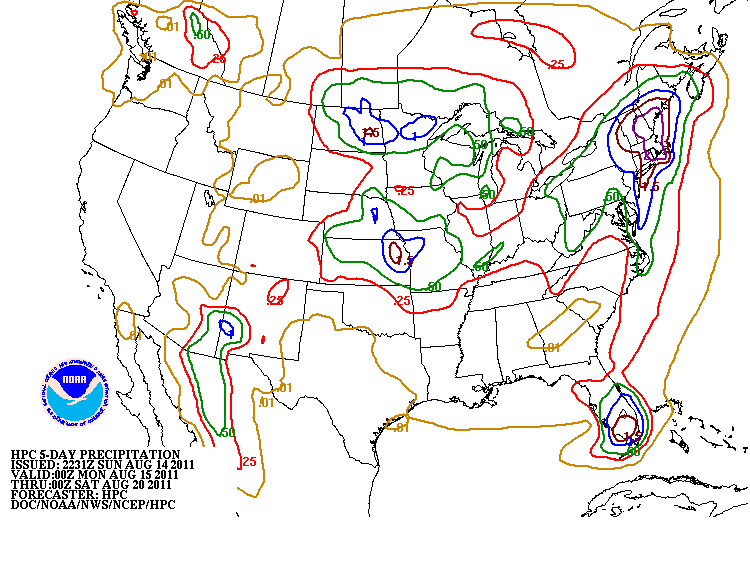
I don't claim to be any kind of expert on trees, but driving around the last few days I could not help but notice the many trees that have lost or are in the process of losing their leaves. I have been told that is a defense mechanism on their part, but I have to wonder if the recent rains will revive them or if perhaps they may pose an enhanced fire danger threat sometime in the future. Anyway, the rain and break in the heat over this past week has certainly brought some welcome relief. Any additional rainfall during the coming week is expected to be rather spotty. As you can see from the QPF(Quantitative Precipitation Forecast) on the right which is valid through Friday evening, any additional showers or storms are expected to be mostly just north of us.
The reason is the upper level ridge which has been so dominant will be meandering around over the southern Rockies as we go through the coming week and that will produce a weak W to NW flow aloft. The stronger jet stream and therefore the main storm track will be north of us which will place us on the southern fringe of most of the activity. Even so, there is at least a chance that some of those storms will drop into the state with the more northern counties having the best shot at some additional rains this week. Right now, it appears that late Monday night and into the morning hours of Tuesday will have a shot at some of those storms dropping down out of Kansas and perhaps another round each of the next few days after that.
The recent rainfall has also left an extensive rain footprint for our part of the state as mentioned in the morning blog. This will help mitigate how much we will heat up this week, but at the cost of higher humidity levels and a heat index that will likely be at or above 100. The actual air temperature should be back above normal for this time of year for Monday and the rest of the week for that matter. In fact, we could approach triple digits, particularly in the more western and southern counties by Wednesday. Am reluctant to go that high right now because of the expected effects of at least some afternoon cloudiness, the higher humidity levels mentioned earlier, and the possibility of at least a few shower or storms around. If those do not materialize, then we could see triple digits by mid week.
Also, our winds will be returning to a more southerly direction which will translate into warmer nights. Bottom line is last weeks cooler and wetter conditions will lead to this weeks hot and humid conditions. In fact, the latest guidance suggests that triple digits appear more likely by this coming weekend, particularly if the spotty showers and storms between now and then do not keep us from drying out too much.
In the meantime, stay tuned, stay cool, and check back for updates.
Dick Faurot

Get The Daily Update!
Be among the first to get breaking news, weather, and general news updates from News on 6 delivered right to your inbox!
More Like This
August 14th, 2011

September 29th, 2024

September 17th, 2024

Top Headlines

December 12th, 2024

December 12th, 2024

December 12th, 2024
