

Heat Wave Continues
Any cooling showers or storms will be even harder to come by this week as the heat continues to build.Sunday, July 31st 2011, 10:35 am

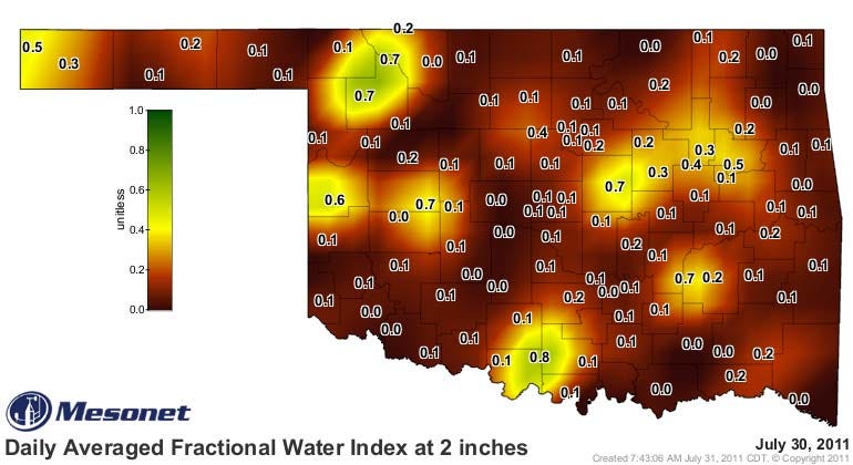
Brutal. That pretty well sums up my forecast for the coming week. This heat is just relentless and there is no end in sight, at least not for the coming week. Was hoping and praying that the clouds and what showers we have had over the last few days would be more widespread than they turned out to be. That would have left a more robust rain footprint which would mitigate the heat to a certain extent. Notice the soil moisture map on the right from the OK Mesonet. Pretty bleak picture and it will only get worse. Although there remains some moisture trapped under the upper level ridge and a few showers may form, the chances of any one location receiving measurable rainfall is only on the order of 10% today, and even less than that for the rest of the week.
Ridging aloft will be centered pretty much right over the state all this week which will result in mostly sunny skies during the day, generally fair skies at night, and light winds. Those winds will not provide much in the way of ventilation either since the winds will be generally less than 10 mph during the day and even less than that at night. Also, the wind direction will be an important factor in how hot it gets. A more westerly component is a hotter, drier wind for us because as the air descends in elevation then compressional warming will occur. That is exactly what is expected by the Tue/Wed time frame and daytime temperatures will likely be around the 110 mark, particularly for locations to the W of I-44. In case you are wondering, the last time we were that hot was a 111 in July of 1996 and we had a SW wind on that particular day.
Another factor will be the effect of the humidity. Dew point temperatures remain rather high this morning with values in the upper 60s to around 70. We expect those to be mixing out this afternoon but the heat index will still be another 2-6 degrees higher than the air temperature for today. Over the coming week, it looks like the moisture will mix out even more with dew point temperatures likely dropping into the lower 60s if not the 50s. That means the heat index will not be much different than the air temperature as relative humidity values will be in the low 20% range if not even into the teens.
Keep in mind also that when we are talking about the air temperature, it is measured in the shade. When in direct sunlight, you can add another 10-15 degrees to what your body is fighting against trying to stay cool.
As far as when this pattern may change, there are some subtle indications of minor changes later in the week, but nothing I would bet the farm on just yet. Also, the longer range guidance continues to suggest a pattern change beyond the 10 day time frame, but it has been doing that for weeks now and obviously that has not happened yet.
So, try to stay cool, stay tuned, and check back for updates.
Dick Faurot

Get The Daily Update!
Be among the first to get breaking news, weather, and general news updates from News on 6 delivered right to your inbox!
More Like This
July 31st, 2011

September 29th, 2024

September 17th, 2024

Top Headlines

December 14th, 2024

December 14th, 2024

December 14th, 2024

December 14th, 2024