

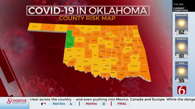
OSMA Says Color Coded COVID-19 Map Can Cause Confusion
The State Medical Association said there is some confusion on what Oklahoma's color coded COVID-19 map shows versus the federal one.Thursday, September 17th 2020, 8:31 am
The State Medical Association said there is some confusion on what Oklahoma's color coded COVID-19 map shows versus the federal one.
This week's map from the state health department shows no counties in red and most of the state in orange.
Doctor George Monks with the state medical association said the map can be hard to understand and could give people a false sense of security.
"I have compared the current COVID alert map to a tornado siren, but right now the tornado siren doesn't sound until the tornado has already hit. We have to change that and I am hopeful that the Oklahoma State Department of Health will address that," said Monks.
According to Monks, the data and map put out by the White House coronavirus task force is the data people should follow.

Get The Daily Update!
Be among the first to get breaking news, weather, and general news updates from News on 6 delivered right to your inbox!
More Like This
September 17th, 2020

October 25th, 2022

February 16th, 2022
February 14th, 2022
Top Headlines

December 11th, 2024

December 11th, 2024

December 11th, 2024

December 11th, 2024