Early Morning Patchy Frost, Highs In The Upper 50s, Lower 60s
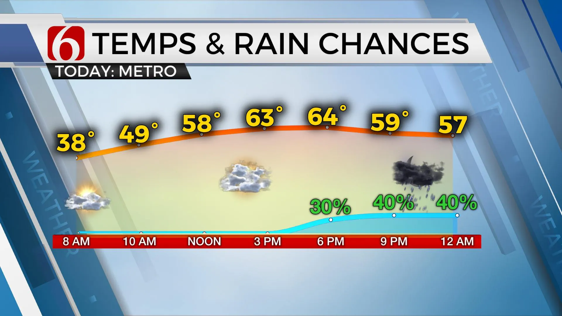
Some patchy frost is underway early this morning across far northeastern OK where clear sky and mostly light winds remain for a short period. Clouds will quickly arrive today from the south with highs reaching the upper 50s and lower 60s along with gusty south winds before our next storm system begins influencing the area with showers and storms. The main window for most of the area will be Friday, but a few showers will develop later tonight near and north of the metro as low-level moisture retThursday, April 22nd 2021, 7:01 am
TULSA, Oklahoma -
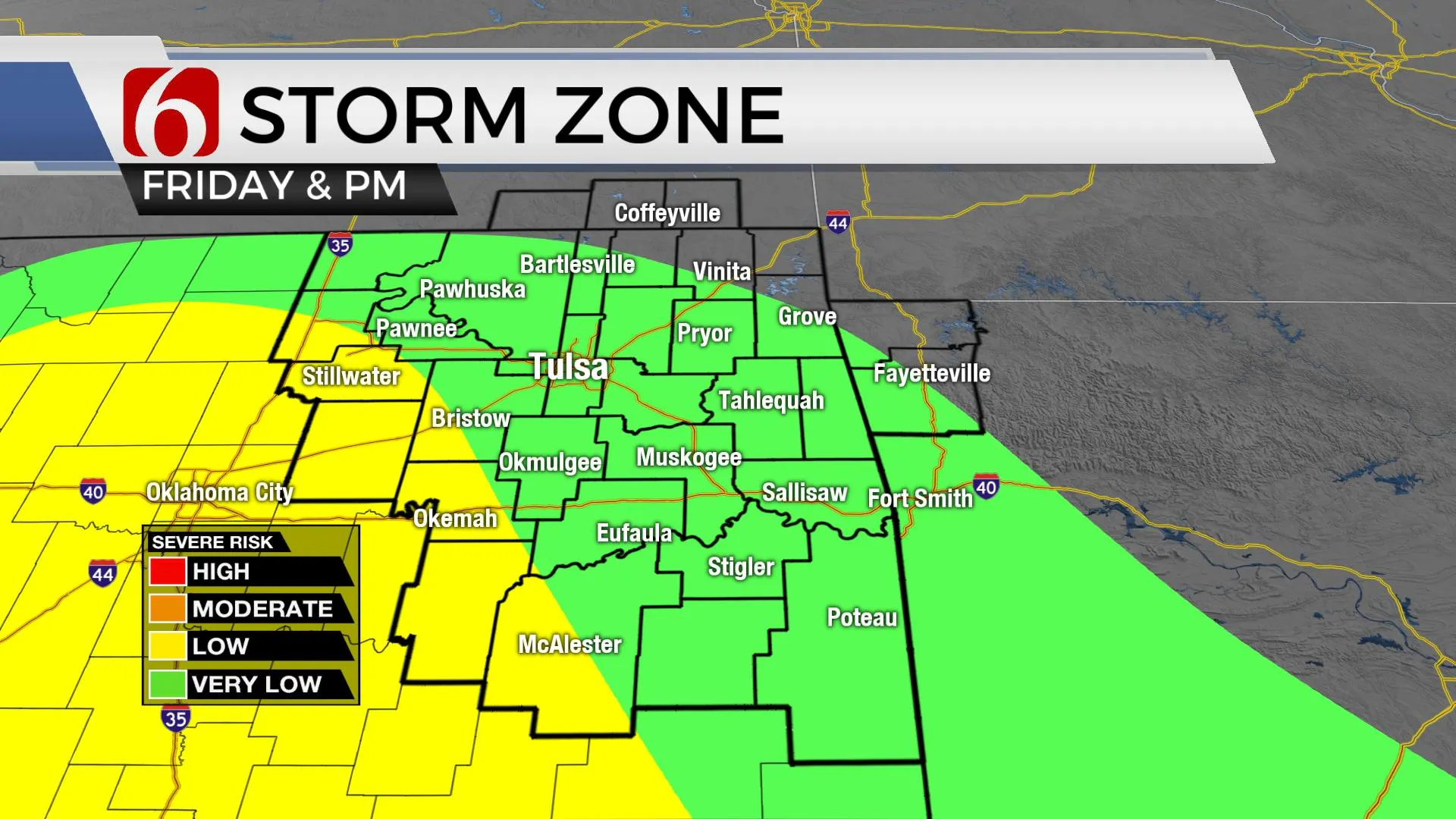
Some patchy frost is underway early this morning across far northeastern OK where clear sky and mostly light winds remain for a short period. Clouds will quickly arrive today from the south with highs reaching the upper 50s and lower 60s along with gusty south winds before our next storm system begins influencing the area with showers and storms. The main window for most of the area will be Friday, but a few showers will develop later tonight near and north of the metro as low-level moisture returns ahead of an upper-level impulse. A few rumbles of thunder with this activity tonight across northern OK or southern Kansas, but the odds of strong storms activity will remain very low. Friday morning gusty south winds bring dew points in the 50s nearing 60 back across the state with even better moisture located near the Arbuckles southward along the Red River Valley. A few storms will develop tomorrow morning through midday, but our main window will remain later Friday afternoon and evening when strong to severe storms will be possible. The main threat for eastern OK will be large hail and damaging winds, but a small window for a tornado warning will remain, mostly west of the Tulsa metro late Friday afternoon and early evening. Most of this system will be exiting our main area of concern pre-dawn Saturday. This means our weekend weather currently looks good, including lows in the 40s and 50s and highs Saturday near 70 and Sunday into the upper 70s. Gusty north winds are likely Saturday behind the departing cold front, but south winds quickly return Sunday as a powerful upper-level system develops across the western U.S. and moves eastward bringing severe weather threats across the plains Tuesday, possibly into early Wednesday. This system has the potential to produce some significant severe weather based on some early model parameters. While it is too early to know any specifics such as timing and exact threat levels, the pattern associated with the Tuesday system is conducive to severe weather. Before this system arrives, we’re focused on the Friday storm chances.

Several items of interest will support severe storms Friday across part of the state, including a deepening and robust low-level moisture return, a surface low positioned near the Red River Valley, a dry line southward from the low and a developing cold front moving southeast Friday afternoon and evening. A layer of warm air aloft may keep Friday morning to midday storms elevated, but by late afternoon and evening, parameters suggest storms will attempt to develop along the dry line near I-35, and also along the southeastward moving cold front by the late evening hours. As storms develop into southeastern or east-central Ok Friday evening, a linear model is more likely. But any discrete storms tomorrow afternoon or early evening could produce super cellular characteristics.

Thanks for reading the Thursday morning weather discussion and blog.
Have a super great day!
Alan Crone
KOTV
If you’re into podcasts, check out my daily weather update below. Search for NewsOn6 and ‘Weather Out The Door’ on most podcast providers, including Apple, Stitcher, Tune-In and down below on Spotify.

More Like This
April 22nd, 2021
February 14th, 2022
January 26th, 2022
January 25th, 2022
Top Headlines
December 13th, 2024
December 13th, 2024
December 13th, 2024
December 13th, 2024


